![](/images/other/stat-length.png)
![Tocht Te voet Werbach - Liebliches Taubertal – Rundwanderweg 7 – Muschelkalk und Orchideen - Photo](https://media.geolcdn.com/t/1900/400/1fdb2358-9b1a-47c1-99aa-4a329dd5204c.jpeg&format=pjpeg&maxdim=2)
Liebliches Taubertal – Rundwanderweg 7 – Muschelkalk und Orchideen
SityTrail - itinéraires balisés pédestres
Tous les sentiers balisés d’Europe GUIDE+
![Lengte](/images/other/stat-length.png)
![Max. hoogte](https://static1.geolcdn.com/siteimages/upload/files/1508320355ic_sort_altitude_max_24dp.png)
![Positief hoogteverschil](https://static1.geolcdn.com/siteimages/upload/files/1508320355ic_sort_den_pos_24dp.png)
![Km-Effort](/images/other/stat-length.png)
![Min. hoogte](https://static1.geolcdn.com/siteimages/upload/files/1508320355ic_sort_altitude_min_24dp.png)
![Negatief hoogteverschil](https://static1.geolcdn.com/siteimages/upload/files/1508320355ic_sort_den_neg_24dp.png)
![Boucle](https://static1.geolcdn.com/siteimages/upload/files/16400158638029165_repeat_loop_refresh_sync_direction_icon.png)
![Te voet](https://static1.geolcdn.com/sitytour/trail-icons/100.png)
3h55
Moeilijkheid : Gemakkelijk
![Scan deze QR-code om de tocht te openen in de SityTrail-applicatie](https://capi.geolives.com/qq0zvz2zws4bq2lad0pu/sitytour/trails/3099672/qr.png?size=200)
Gratisgps-wandelapplicatie
Over ons
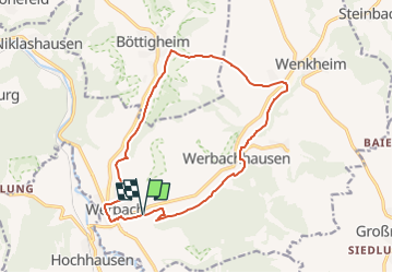
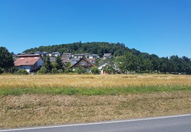
Tocht Te voet van 14,2 km beschikbaar op Baden-Württemberg, Main-Tauber-Kreis, Werbach. Deze tocht wordt voorgesteld door SityTrail - itinéraires balisés pédestres.
Beschrijving
Trail created by Tourismusverband „Liebliches Taubertal“.
Symbol: weißes LT 7 auf blauen Grund
Website: https://www.liebliches-taubertal.de/Aktiv/Wandern/Rundwanderungen/Wanderung-Nr-7-Muschelkalk-und-Orchideen.html
Plaatsbepaling
Opmerkingen
Wandeltochten in de omgeving
![Tocht Te voet Werbach - Rundwanderweg Gamburg 1 - Photo](https://media.geolcdn.com/t/375/260/bf6f2131-076c-419d-9b06-e72ce843a917.jpeg&format=jpg&maxdim=2)
![Te voet Te voet](https://static1.geolcdn.com/sitytour/trail-icons/100.png)
Te voet
![](/images/other/stat-length.png)
![](https://static1.geolcdn.com/siteimages/upload/files/16400158638029165_repeat_loop_refresh_sync_direction_icon.png)
![Tocht Te voet Werbach - Rundwanderweg Gamburg 6 - Photo](https://media.geolcdn.com/t/375/260/83afd43d-bbd6-4c00-a4de-95dd32ba431b.jpeg&format=jpg&maxdim=2)
![Te voet Te voet](https://static1.geolcdn.com/sitytour/trail-icons/100.png)
Te voet
![](/images/other/stat-length.png)
![](https://static1.geolcdn.com/siteimages/upload/files/16400158638029165_repeat_loop_refresh_sync_direction_icon.png)
![Tocht Te voet Werbach - Rundwanderweg Gamburg 4 - Photo](https://media.geolcdn.com/t/375/260/83afd43d-bbd6-4c00-a4de-95dd32ba431b.jpeg&format=jpg&maxdim=2)
![Te voet Te voet](https://static1.geolcdn.com/sitytour/trail-icons/100.png)
Te voet
![](/images/other/stat-length.png)
![](https://static1.geolcdn.com/siteimages/upload/files/16400158638029165_repeat_loop_refresh_sync_direction_icon.png)
![Tocht Te voet Werbach - Rundwanderweg Gamburg 3 - Photo](https://media.geolcdn.com/t/375/260/bf6f2131-076c-419d-9b06-e72ce843a917.jpeg&format=jpg&maxdim=2)
![Te voet Te voet](https://static1.geolcdn.com/sitytour/trail-icons/100.png)
Te voet
![](/images/other/stat-length.png)
![](https://static1.geolcdn.com/siteimages/upload/files/16400158638029165_repeat_loop_refresh_sync_direction_icon.png)
![Tocht Te voet Werbach - Rundwanderweg Gamburg 2 - Photo](https://media.geolcdn.com/t/375/260/da22b0cf-be0c-4c09-9908-d3b298519672.jpeg&format=jpg&maxdim=2)
![Te voet Te voet](https://static1.geolcdn.com/sitytour/trail-icons/100.png)
Te voet
![](/images/other/stat-length.png)
![](https://static1.geolcdn.com/siteimages/upload/files/16400158638029165_repeat_loop_refresh_sync_direction_icon.png)