![](/images/other/stat-length.png)
![Tocht Te voet Staudernheim - Staudernheimer Hang - Photo](https://media.geolcdn.com/t/1900/400/cb52bf2b-3125-4d54-8c0d-9cbc9e9d6891.jpeg&format=pjpeg&maxdim=2)
Staudernheimer Hang
SityTrail - itinéraires balisés pédestres
Tous les sentiers balisés d’Europe GUIDE+
![Lengte](/images/other/stat-length.png)
![Max. hoogte](https://static1.geolcdn.com/siteimages/upload/files/1508320355ic_sort_altitude_max_24dp.png)
![Positief hoogteverschil](https://static1.geolcdn.com/siteimages/upload/files/1508320355ic_sort_den_pos_24dp.png)
![Km-Effort](/images/other/stat-length.png)
![Min. hoogte](https://static1.geolcdn.com/siteimages/upload/files/1508320355ic_sort_altitude_min_24dp.png)
![Negatief hoogteverschil](https://static1.geolcdn.com/siteimages/upload/files/1508320355ic_sort_den_neg_24dp.png)
![Boucle](https://static1.geolcdn.com/siteimages/upload/files/16400158638029165_repeat_loop_refresh_sync_direction_icon.png)
![Te voet](https://static1.geolcdn.com/sitytour/trail-icons/100.png)
1h54
Moeilijkheid : Gemakkelijk
![Scan deze QR-code om de tocht te openen in de SityTrail-applicatie](https://capi.geolives.com/qq0zvz2zws4bq2lad0pu/sitytour/trails/3099060/qr.png?size=200)
Gratisgps-wandelapplicatie
Over ons
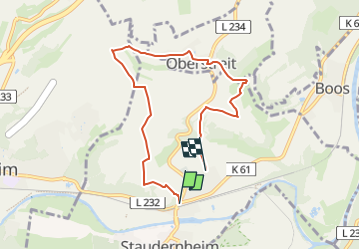
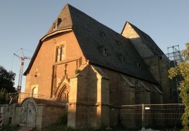
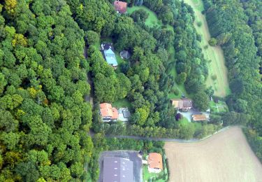
Tocht Te voet van 6,3 km beschikbaar op Rijnland-Palts, Landkreis Bad Kreuznach, Staudernheim. Deze tocht wordt voorgesteld door SityTrail - itinéraires balisés pédestres.
Beschrijving
Trail created by Ferienregion Bad Sobernheim.
Symbol: weißes Schild, mittig gelbe Raute mit kleinerem und größerem Wanderer in Weiß, überschrieben mit "Ferienregion" und "Bad Sobernheim", unterschrieben mit "Staudernheimer Hang"
Plaatsbepaling
Opmerkingen
Wandeltochten in de omgeving
![Tocht Te voet Waldböckelheim - Waldböckelheimer](https://media.geolcdn.com/t/375/260/43693554-d6fe-47e5-bb3d-b573d93b751d.jpeg&format=jpg&maxdim=2)
![Te voet Te voet](https://static1.geolcdn.com/sitytour/trail-icons/100.png)
Te voet
![](/images/other/stat-length.png)
![](https://static1.geolcdn.com/siteimages/upload/files/16400158638029165_repeat_loop_refresh_sync_direction_icon.png)
![Tocht Te voet Odernheim am Glan - Humbergtour - Photo](https://media.geolcdn.com/t/375/260/7e5cda45-3ad4-4bc2-8422-5cd9a3d419e8.jpeg&format=jpg&maxdim=2)
![Te voet Te voet](https://static1.geolcdn.com/sitytour/trail-icons/100.png)
Te voet
![](/images/other/stat-length.png)
![](https://static1.geolcdn.com/siteimages/upload/files/16400158638029165_repeat_loop_refresh_sync_direction_icon.png)
![Tocht Te voet Bad Sobernheim - Wanderweg Bad Sobernheim - Steinhardt - Photo](https://media.geolcdn.com/t/375/260/e0430d41-e145-4740-9f2e-88856eeb2e61.jpeg&format=jpg&maxdim=2)
![Te voet Te voet](https://static1.geolcdn.com/sitytour/trail-icons/100.png)
Te voet
![](/images/other/stat-length.png)
![](https://static1.geolcdn.com/siteimages/upload/files/16400158638029165_repeat_loop_refresh_sync_direction_icon.png)
![Tocht Te voet Odernheim am Glan - Rundwanderweg Odernheim 1 - Photo](https://media.geolcdn.com/t/375/260/7e5cda45-3ad4-4bc2-8422-5cd9a3d419e8.jpeg&format=jpg&maxdim=2)
![Te voet Te voet](https://static1.geolcdn.com/sitytour/trail-icons/100.png)
Te voet
![](/images/other/stat-length.png)
![](https://static1.geolcdn.com/siteimages/upload/files/16400158638029165_repeat_loop_refresh_sync_direction_icon.png)
![Tocht Te voet Bad Sobernheim - Neues Leben S1 - Photo](https://media.geolcdn.com/t/375/260/e1c5259c-b016-416b-8d56-c335068ca274.jpeg&format=jpg&maxdim=2)
![Te voet Te voet](https://static1.geolcdn.com/sitytour/trail-icons/100.png)
Te voet
![](/images/other/stat-length.png)
![](https://static1.geolcdn.com/siteimages/upload/files/16400158638029165_repeat_loop_refresh_sync_direction_icon.png)
![Tocht Te voet Bad Sobernheim - Hubertuslust S2 - Photo](https://media.geolcdn.com/t/375/260/e1c5259c-b016-416b-8d56-c335068ca274.jpeg&format=jpg&maxdim=2)
![Te voet Te voet](https://static1.geolcdn.com/sitytour/trail-icons/100.png)
Te voet
![](/images/other/stat-length.png)
![](https://static1.geolcdn.com/siteimages/upload/files/16400158638029165_repeat_loop_refresh_sync_direction_icon.png)
![Tocht Te voet Odernheim am Glan - Rundwanderweg Odernheim 3 - Photo](https://media.geolcdn.com/t/375/260/ext.jpg?maxdim=2&url=https%3A%2F%2Fstatic1.geolcdn.com%2Fsiteimages%2Fupload%2Ffiles%2F1545311037marcheuse_200dpi.jpg)
![Te voet Te voet](https://static1.geolcdn.com/sitytour/trail-icons/100.png)
Te voet
![](/images/other/stat-length.png)
![](https://static1.geolcdn.com/siteimages/upload/files/16400158638029165_repeat_loop_refresh_sync_direction_icon.png)
![Tocht Te voet Meddersheim - Natur-Erlebnis-Weg >Lebendige Nahe< - Photo](https://media.geolcdn.com/t/375/260/ext.jpg?maxdim=2&url=https%3A%2F%2Fstatic1.geolcdn.com%2Fsiteimages%2Fupload%2Ffiles%2F1545311037marcheuse_200dpi.jpg)
![Te voet Te voet](https://static1.geolcdn.com/sitytour/trail-icons/100.png)
Te voet
![](/images/other/stat-length.png)
![](https://static1.geolcdn.com/siteimages/upload/files/16400158638029165_repeat_loop_refresh_sync_direction_icon.png)