Tocht Te voet Salzatal - Braunkohlenpfad - Photo

Tous les sentiers balisés d’Europe PRO

© OpenStreetMap contributors
Lengte
Lengte
11,6 km
Max. hoogte
Max. hoogte
120 m
Positief hoogteverschil
128 m
Km-Effort
Km-Effort  
13,3 km
Min. hoogte
Min. hoogte
76 m
Negatief hoogteverschil
130 m
Boucle
Boucle
Neen
Markering
Markering
Datum van aanmaak :
2022-02-11 18:05:37.07
Laatste wijziging :
2022-02-11 18:05:37.07

(0 Bericht)

Te voet
Te voet
3h01
Moeilijkheid : Gemakkelijk

Scan deze QR-code om de tocht te openen in de SityTrail-applicatie

Gratisgps-wandelapplicatie

Logo SityTrail SityTrail

IGN / Geografische instituten

SityTrail uit de App Store downloaden SityTrail uit Google Play downloaden

Logo SityTrail SityTrail World

De wereld gaat voor u open

SityTrail uit de App Store downloaden SityTrail uit Google Play downloaden SityTrail op Huawei AppGallery downloaden

Over ons

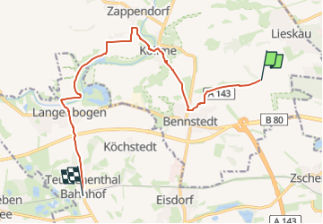
Tocht Te voet van 11,6 km beschikbaar op Saksen-Anhalt, Saalekreis, Salzatal. Deze tocht wordt voorgesteld door SityTrail - itinéraires balisés pédestres.

Beschrijving

Trail created by IG-Waldheit Lieskau.

Symbol: Schwarze gekreuzte Hämmer auf weissem Rechteck


Website: http://www.ig-waldheil.de/braunkohlenpfad/209-braunkohlenpfad

Foto's

Plaatsbepaling

Land:
Germany
Regio :
Saksen-Anhalt
Departement/Provincie :
Saalekreis
Gemeente :
Salzatal
Locatie:
Unknown
Vertrek:(UTM)
697967 ; 5708347 (32U) N.

Wandeltochten in de omgeving

Tocht Te voet Petersberg - Brachwitzer Alpen - Photo
Te voet
PRO

Te voet

Gemakkelijk
Petersberg, Saksen-Anhalt, Saalekreis, Germany
3,2 km | 3,8 km-effort
52min
Ja


Sluiten
Mijn abonnementen