![](/images/other/stat-length.png)
![Tocht Te voet Kaltennordheim - Feldatalrundweg - Photo](https://media.geolcdn.com/t/1900/400/dc5e57f6-a6d4-48b9-81d1-1d1a48c14d5d.jpeg&format=pjpeg&maxdim=2)
Feldatalrundweg
SityTrail - itinéraires balisés pédestres
Tous les sentiers balisés d’Europe GUIDE+
![Lengte](/images/other/stat-length.png)
![Max. hoogte](https://static1.geolcdn.com/siteimages/upload/files/1508320355ic_sort_altitude_max_24dp.png)
![Positief hoogteverschil](https://static1.geolcdn.com/siteimages/upload/files/1508320355ic_sort_den_pos_24dp.png)
![Km-Effort](/images/other/stat-length.png)
![Min. hoogte](https://static1.geolcdn.com/siteimages/upload/files/1508320355ic_sort_altitude_min_24dp.png)
![Negatief hoogteverschil](https://static1.geolcdn.com/siteimages/upload/files/1508320355ic_sort_den_neg_24dp.png)
![Boucle](https://static1.geolcdn.com/siteimages/upload/files/16400158638029165_repeat_loop_refresh_sync_direction_icon.png)
![Te voet](https://static1.geolcdn.com/sitytour/trail-icons/100.png)
4h47
Moeilijkheid : Medium
![Scan deze QR-code om de tocht te openen in de SityTrail-applicatie](https://capi.geolives.com/qq0zvz2zws4bq2lad0pu/sitytour/trails/3098765/qr.png?size=200)
Gratisgps-wandelapplicatie
Over ons
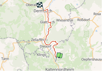
Tocht Te voet van 15,2 km beschikbaar op Thüringen, Landkreis Schmalkalden-Meiningen, Kaltennordheim. Deze tocht wordt voorgesteld door SityTrail - itinéraires balisés pédestres.
Beschrijving
Trail created by Rhönklub.
Symbol: schwarzes F auf weißem Grund
Website: http://rhoenklub.de/_d-upl/rhoenklub_rundwegflyer_12_seiter_240914K7_ansicht.pdf
Plaatsbepaling
Opmerkingen
Wandeltochten in de omgeving
![Tocht Te voet Hausen - Rhön-Rundweg Hausen 6 - Photo](https://media.geolcdn.com/t/375/260/ce58b82d-635b-4292-a930-77ddec40da9b.jpeg&format=jpg&maxdim=2)
![Te voet Te voet](https://static1.geolcdn.com/sitytour/trail-icons/100.png)
Te voet
![](/images/other/stat-length.png)
![](https://static1.geolcdn.com/siteimages/upload/files/16400158638029165_repeat_loop_refresh_sync_direction_icon.png)
![Tocht Te voet Nordheim v.d.Rhön - Rhön-Rundweg Ostheim 5 - Photo](https://media.geolcdn.com/t/375/260/69671785-8cb7-4f78-9c66-a72d6aa62a06.jpeg&format=jpg&maxdim=2)
![Te voet Te voet](https://static1.geolcdn.com/sitytour/trail-icons/100.png)
Te voet
![](/images/other/stat-length.png)
![](https://static1.geolcdn.com/siteimages/upload/files/16400158638029165_repeat_loop_refresh_sync_direction_icon.png)
![Tocht Te voet Sondheim v.d.Rhön - Rundweg Rother Kuppe - Photo](https://media.geolcdn.com/t/375/260/69671785-8cb7-4f78-9c66-a72d6aa62a06.jpeg&format=jpg&maxdim=2)
![Te voet Te voet](https://static1.geolcdn.com/sitytour/trail-icons/100.png)
Te voet
![](/images/other/stat-length.png)
![](https://static1.geolcdn.com/siteimages/upload/files/16400158638029165_repeat_loop_refresh_sync_direction_icon.png)
![Tocht Te voet Willmars - Fladungen-Mellrichstadt - Photo](https://media.geolcdn.com/t/375/260/9f12fb27-f252-4356-aec9-a4f912d4df26.jpeg&format=jpg&maxdim=2)
![Te voet Te voet](https://static1.geolcdn.com/sitytour/trail-icons/100.png)
Te voet
![](/images/other/stat-length.png)
![](https://static1.geolcdn.com/siteimages/upload/files/16400158638029165_repeat_loop_refresh_sync_direction_icon.png)
![Tocht Te voet Nordheim v.d.Rhön - Rhön-Rundweg](https://media.geolcdn.com/t/375/260/69671785-8cb7-4f78-9c66-a72d6aa62a06.jpeg&format=jpg&maxdim=2)
![Te voet Te voet](https://static1.geolcdn.com/sitytour/trail-icons/100.png)
Te voet
![](/images/other/stat-length.png)
![](https://static1.geolcdn.com/siteimages/upload/files/16400158638029165_repeat_loop_refresh_sync_direction_icon.png)
![Tocht Te voet Ehrenberg - Zubringer Wüstensachsen - Photo](https://media.geolcdn.com/t/375/260/01b4bef0-11d8-4d1d-bc2a-3d5c2459220c.jpeg&format=jpg&maxdim=2)
![Te voet Te voet](https://static1.geolcdn.com/sitytour/trail-icons/100.png)
Te voet
![](/images/other/stat-length.png)
![](https://static1.geolcdn.com/siteimages/upload/files/16400158638029165_repeat_loop_refresh_sync_direction_icon.png)
![Tocht Te voet Hofbieber - Extratour Milseburg - Photo](https://media.geolcdn.com/t/375/260/984d263a-bf6b-45a8-b583-6f3b5e1a01e5.jpeg&format=jpg&maxdim=2)
![Te voet Te voet](https://static1.geolcdn.com/sitytour/trail-icons/100.png)
Te voet
![](/images/other/stat-length.png)
![](https://static1.geolcdn.com/siteimages/upload/files/16400158638029165_repeat_loop_refresh_sync_direction_icon.png)
![Tocht Te voet Ehrenberg - Extratour Rotes Moor - Photo](https://media.geolcdn.com/t/375/260/0cdd8b87-9f6a-41b7-9dfb-41d03d8c4ae1.jpeg&format=jpg&maxdim=2)
![Te voet Te voet](https://static1.geolcdn.com/sitytour/trail-icons/100.png)
Te voet
![](/images/other/stat-length.png)
![](https://static1.geolcdn.com/siteimages/upload/files/16400158638029165_repeat_loop_refresh_sync_direction_icon.png)