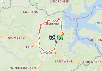
![](/images/other/stat-length.png)
![Tocht Te voet Odenthal - D8 - Über den Bömberg - Photo](https://media.geolcdn.com/t/1900/400/3b32deb4-e024-444d-9e76-b5a340d75832.jpeg&format=pjpeg&maxdim=2)
D8 - Über den Bömberg
SityTrail - itinéraires balisés pédestres
Tous les sentiers balisés d’Europe GUIDE+
![Lengte](/images/other/stat-length.png)
![Max. hoogte](https://static1.geolcdn.com/siteimages/upload/files/1508320355ic_sort_altitude_max_24dp.png)
![Positief hoogteverschil](https://static1.geolcdn.com/siteimages/upload/files/1508320355ic_sort_den_pos_24dp.png)
![Km-Effort](/images/other/stat-length.png)
![Min. hoogte](https://static1.geolcdn.com/siteimages/upload/files/1508320355ic_sort_altitude_min_24dp.png)
![Negatief hoogteverschil](https://static1.geolcdn.com/siteimages/upload/files/1508320355ic_sort_den_neg_24dp.png)
![Boucle](https://static1.geolcdn.com/siteimages/upload/files/16400158638029165_repeat_loop_refresh_sync_direction_icon.png)
![Te voet](https://static1.geolcdn.com/sitytour/trail-icons/100.png)
1h18
Moeilijkheid : Gemakkelijk
![Scan deze QR-code om de tocht te openen in de SityTrail-applicatie](https://capi.geolives.com/qq0zvz2zws4bq2lad0pu/sitytour/trails/3097955/qr.png?size=200)
Gratisgps-wandelapplicatie
Over ons
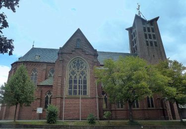
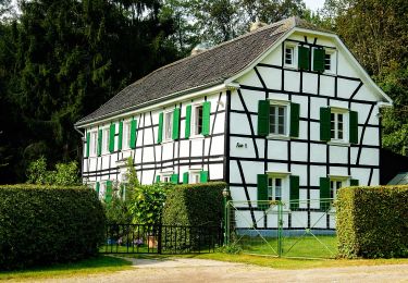
Tocht Te voet van 4,6 km beschikbaar op Noordrijn-Westfalen, Rheinisch-Bergischer Kreis, Odenthal. Deze tocht wordt voorgesteld door SityTrail - itinéraires balisés pédestres.
Beschrijving
Trail created by Sauerländischer Gebirgsverein.
Symbol: Weißes "D8" auf scharzem Grund
Website: https://www.wermelskirchen.de/fileadmin/user_upload/Dokumente/Tourismus/Dhuennhochflaeche_D8.pdf
Plaatsbepaling
Opmerkingen
Wandeltochten in de omgeving
![Tocht Te voet Odenthal - Odenthal Rundweg A3 - Photo](https://media.geolcdn.com/t/375/260/5c0c5eda-d0de-4bc8-b3c6-93c221a26070.jpeg&format=jpg&maxdim=2)
![Te voet Te voet](https://static1.geolcdn.com/sitytour/trail-icons/100.png)
Te voet
![](/images/other/stat-length.png)
![](https://static1.geolcdn.com/siteimages/upload/files/16400158638029165_repeat_loop_refresh_sync_direction_icon.png)
![Tocht Te voet Odenthal - Odenthal Rundweg A2 - Photo](https://media.geolcdn.com/t/375/260/5c0c5eda-d0de-4bc8-b3c6-93c221a26070.jpeg&format=jpg&maxdim=2)
![Te voet Te voet](https://static1.geolcdn.com/sitytour/trail-icons/100.png)
Te voet
![](/images/other/stat-length.png)
![](https://static1.geolcdn.com/siteimages/upload/files/16400158638029165_repeat_loop_refresh_sync_direction_icon.png)
![Tocht Te voet Odenthal - Hüttchen Rundweg A2 - Photo](https://media.geolcdn.com/t/375/260/3b32deb4-e024-444d-9e76-b5a340d75832.jpeg&format=jpg&maxdim=2)
![Te voet Te voet](https://static1.geolcdn.com/sitytour/trail-icons/100.png)
Te voet
![](/images/other/stat-length.png)
![](https://static1.geolcdn.com/siteimages/upload/files/16400158638029165_repeat_loop_refresh_sync_direction_icon.png)
![Tocht Te voet Burscheid - Rundweg Burscheid - Benninghausen - Burscheid - Photo](https://media.geolcdn.com/t/375/260/fae1b87f-ded6-4b8b-821d-395fcdf8bba1.jpeg&format=jpg&maxdim=2)
![Te voet Te voet](https://static1.geolcdn.com/sitytour/trail-icons/100.png)
Te voet
![](/images/other/stat-length.png)
![](https://static1.geolcdn.com/siteimages/upload/files/16400158638029165_repeat_loop_refresh_sync_direction_icon.png)
![Tocht Te voet Burscheid - Rundweg Burscheid - Grünscheid - Burscheid - Photo](https://media.geolcdn.com/t/375/260/ab53fe57-0b5d-44ae-b1ff-e67c9feb0d63.jpeg&format=jpg&maxdim=2)
![Te voet Te voet](https://static1.geolcdn.com/sitytour/trail-icons/100.png)
Te voet
![](/images/other/stat-length.png)
![](https://static1.geolcdn.com/siteimages/upload/files/16400158638029165_repeat_loop_refresh_sync_direction_icon.png)
![Tocht Te voet Odenthal - Eifgenbachtalweg - Photo](https://media.geolcdn.com/t/375/260/8fd76f57-39d8-47a1-aa22-55c2f9ae7f18.jpeg&format=jpg&maxdim=2)
![Te voet Te voet](https://static1.geolcdn.com/sitytour/trail-icons/100.png)
Te voet
![](/images/other/stat-length.png)
![](https://static1.geolcdn.com/siteimages/upload/files/16400158638029165_repeat_loop_refresh_sync_direction_icon.png)
![Tocht Te voet Wermelskirchen - D4 - Naturwelten - Photo](https://media.geolcdn.com/t/375/260/bc106ab4-d620-4949-9c9e-f02c29880e90.jpeg&format=jpg&maxdim=2)
![Te voet Te voet](https://static1.geolcdn.com/sitytour/trail-icons/100.png)
Te voet
![](/images/other/stat-length.png)
![](https://static1.geolcdn.com/siteimages/upload/files/16400158638029165_repeat_loop_refresh_sync_direction_icon.png)
![Tocht Te voet Wermelskirchen - D3 - Kirchweg - Photo](https://media.geolcdn.com/t/375/260/c61ce69e-f6ea-482e-a162-ed313189b52f.jpeg&format=jpg&maxdim=2)
![Te voet Te voet](https://static1.geolcdn.com/sitytour/trail-icons/100.png)
Te voet
![](/images/other/stat-length.png)
![](https://static1.geolcdn.com/siteimages/upload/files/16400158638029165_repeat_loop_refresh_sync_direction_icon.png)
![Tocht Te voet Burscheid - E3 - Täler und Höhen - Photo](https://media.geolcdn.com/t/375/260/061b268b-ec5f-4237-8ca1-c669372ea049.jpeg&format=jpg&maxdim=2)
![Te voet Te voet](https://static1.geolcdn.com/sitytour/trail-icons/100.png)
Te voet
![](/images/other/stat-length.png)
![](https://static1.geolcdn.com/siteimages/upload/files/16400158638029165_repeat_loop_refresh_sync_direction_icon.png)