![](/images/other/stat-length.png)
![Tocht Te voet Nothweiler - Grenzgängerweg / Le sentier à saute frontier - Photo](https://media.geolcdn.com/t/1900/400/0ec53861-ac09-45f6-98f4-4da71460fa1b.jpeg&format=pjpeg&maxdim=2)
Grenzgängerweg / Le sentier à saute frontier
SityTrail - itinéraires balisés pédestres
Tous les sentiers balisés d’Europe GUIDE+
![Lengte](/images/other/stat-length.png)
![Max. hoogte](https://static1.geolcdn.com/siteimages/upload/files/1508320355ic_sort_altitude_max_24dp.png)
![Positief hoogteverschil](https://static1.geolcdn.com/siteimages/upload/files/1508320355ic_sort_den_pos_24dp.png)
![Km-Effort](/images/other/stat-length.png)
![Min. hoogte](https://static1.geolcdn.com/siteimages/upload/files/1508320355ic_sort_altitude_min_24dp.png)
![Negatief hoogteverschil](https://static1.geolcdn.com/siteimages/upload/files/1508320355ic_sort_den_neg_24dp.png)
![Boucle](https://static1.geolcdn.com/siteimages/upload/files/16400158638029165_repeat_loop_refresh_sync_direction_icon.png)
![Te voet](https://static1.geolcdn.com/sitytour/trail-icons/100.png)
2h26
Moeilijkheid : Gemakkelijk
![Scan deze QR-code om de tocht te openen in de SityTrail-applicatie](https://capi.geolives.com/qq0zvz2zws4bq2lad0pu/sitytour/trails/3097725/qr.png?size=200)
Gratisgps-wandelapplicatie
Over ons
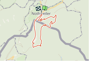
Tocht Te voet van 7,2 km beschikbaar op Rijnland-Palts, Südwestpfalz, Nothweiler. Deze tocht wordt voorgesteld door SityTrail - itinéraires balisés pédestres.
Beschrijving
Symbol: zwei stilisierte blaue Köpfe mit grünem Hut bzw. gelber Baskenmütze auf braunem Grund und in weißem Rahmen, unten links die Wappen von Frankreich und Deutschland und schwarzer Unterschrift "Grenzgängerweg"
Plaatsbepaling
Opmerkingen
Wandeltochten in de omgeving
![Tocht Paardrijden Wingen - 2018-04-07 CRTE Alsace Loewenstein Hohenbourg Fleckenstein - Photo](https://media.geolcdn.com/t/375/260/70102c74-cde7-4712-ad3f-8ece0b83e7cb.jpg&format=jpg&maxdim=2)
![Paardrijden Paardrijden](https://static1.geolcdn.com/sitytour/trail-icons/301.png)
Paardrijden
![](/images/other/stat-length.png)
![](https://static1.geolcdn.com/siteimages/upload/files/16400158638029165_repeat_loop_refresh_sync_direction_icon.png)
![Tocht Stappen Lembach - Fleckenstein, circuit des 5 châteaux. - Photo](https://media.geolcdn.com/t/375/260/ext.jpg?maxdim=2&url=https%3A%2F%2Fservices.sitytrail.com%2FGeolivesWS%2FDownloadMedia.ashx%3FTrailID%3D364388%26Media%3Dfix__20141120164801.jpg)
![Stappen Stappen](https://static1.geolcdn.com/sitytour/trail-icons/101.png)
Stappen
![](/images/other/stat-length.png)
![](https://static1.geolcdn.com/siteimages/upload/files/16400158638029165_repeat_loop_refresh_sync_direction_icon.png)
![Tocht Te voet Lembach - Anneau jaune - Photo](https://media.geolcdn.com/t/375/260/ca3811e6-33d3-4810-a71b-1526bcfc4047.jpeg&format=jpg&maxdim=2)
![Te voet Te voet](https://static1.geolcdn.com/sitytour/trail-icons/100.png)
Te voet
![](/images/other/stat-length.png)
![](https://static1.geolcdn.com/siteimages/upload/files/16400158638029165_repeat_loop_refresh_sync_direction_icon.png)
![Tocht Te voet Wingen - Croix rouge - Photo](https://media.geolcdn.com/t/375/260/59ca20a7-ed62-4c6a-9fd9-47494a5cdd7a.jpeg&format=jpg&maxdim=2)
![Te voet Te voet](https://static1.geolcdn.com/sitytour/trail-icons/100.png)
Te voet
![](/images/other/stat-length.png)
![](https://static1.geolcdn.com/siteimages/upload/files/16400158638029165_repeat_loop_refresh_sync_direction_icon.png)
![Tocht Te voet Wingen - Anneau rouge - Photo](https://media.geolcdn.com/t/375/260/06df198a-1199-44ec-a8d9-2d9a150b410c.jpeg&format=jpg&maxdim=2)
![Te voet Te voet](https://static1.geolcdn.com/sitytour/trail-icons/100.png)
Te voet
![](/images/other/stat-length.png)
![](https://static1.geolcdn.com/siteimages/upload/files/16400158638029165_repeat_loop_refresh_sync_direction_icon.png)
![Tocht Te voet Lembach - Croix rouge - Photo](https://media.geolcdn.com/t/375/260/8214d6ae-8b08-4cfc-b481-39fdcb8b7805.jpeg&format=jpg&maxdim=2)
![Te voet Te voet](https://static1.geolcdn.com/sitytour/trail-icons/100.png)
Te voet
![](/images/other/stat-length.png)
![](https://static1.geolcdn.com/siteimages/upload/files/16400158638029165_repeat_loop_refresh_sync_direction_icon.png)
![Tocht Te voet Wingen - Triangle rouge - Photo](https://media.geolcdn.com/t/375/260/8bd60bff-ac8d-4e94-928a-be498e7aa81d.jpeg&format=jpg&maxdim=2)
![Te voet Te voet](https://static1.geolcdn.com/sitytour/trail-icons/100.png)
Te voet
![](/images/other/stat-length.png)
![](https://static1.geolcdn.com/siteimages/upload/files/16400158638029165_repeat_loop_refresh_sync_direction_icon.png)
![Tocht Te voet Lembach - Anneau bleu - Photo](https://media.geolcdn.com/t/375/260/704edbc3-db60-4c8d-8509-777a0364a0c0.jpeg&format=jpg&maxdim=2)
![Te voet Te voet](https://static1.geolcdn.com/sitytour/trail-icons/100.png)
Te voet
![](/images/other/stat-length.png)
![](https://static1.geolcdn.com/siteimages/upload/files/16400158638029165_repeat_loop_refresh_sync_direction_icon.png)
![Tocht Te voet Nothweiler - Wegelnburg-Tour - Photo](https://media.geolcdn.com/t/375/260/2fad2d9c-a93b-41ab-b1a4-910cffe4363f.jpeg&format=jpg&maxdim=2)
![Te voet Te voet](https://static1.geolcdn.com/sitytour/trail-icons/100.png)
Te voet
![](/images/other/stat-length.png)
![](https://static1.geolcdn.com/siteimages/upload/files/16400158638029165_repeat_loop_refresh_sync_direction_icon.png)