


9,6 km | 12,3 km-effort
![Tocht Te voet Bergneustadt - [11] Feuer&Flamme-Weg - Photo](https://media.geolcdn.com/t/1900/400/237493a2-6cde-46b9-b021-eea46d9cd4bc.jpeg&format=pjpeg&maxdim=2)

Tous les sentiers balisés d’Europe GUIDE+


Gratisgps-wandelapplicatie
 SityTrail
IGN / Geografische instituten
SityTrail World
De wereld gaat voor u open
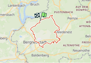
Tocht Te voet van 12,2 km beschikbaar op Noordrijn-Westfalen, Oberbergischer Kreis, Bergneustadt. Deze tocht wordt voorgesteld door SityTrail - itinéraires balisés pédestres.
Trail created by Das Bergische.
Symbol: Weiße 11 auf orangem Hintergrund
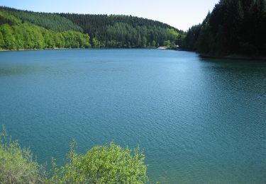
![Tocht Te voet Bergneustadt - [11] Feuer&Flamme-Weg - Photo 1](https://media.geolcdn.com/t/2048/auto/70e58566-5de2-444e-b023-0dc6430879f1.jpeg&format=jpg&maxdim=0 "Tocht Te voet Bergneustadt - [11] Feuer&Flamme-Weg - Photo 1")
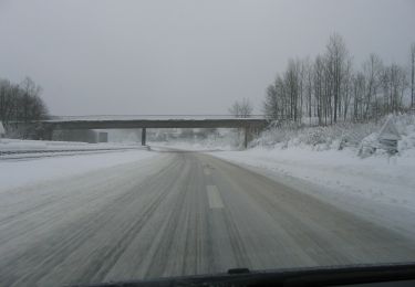
![Tocht Te voet Bergneustadt - [11] Feuer&Flamme-Weg - Photo 2](https://media.geolcdn.com/t/2048/auto/de4e7208-5a7d-4b1e-a393-a0579dba7521.jpeg&format=jpg&maxdim=0 "Tocht Te voet Bergneustadt - [11] Feuer&Flamme-Weg - Photo 2")
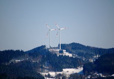
![Tocht Te voet Bergneustadt - [11] Feuer&Flamme-Weg - Photo 3](https://media.geolcdn.com/t/2048/auto/07daad85-a300-41e8-9b85-f08a92d76b9c.jpeg&format=jpg&maxdim=0 "Tocht Te voet Bergneustadt - [11] Feuer&Flamme-Weg - Photo 3")
![Tocht Te voet Bergneustadt - [11] Feuer&Flamme-Weg - Photo 4](https://media.geolcdn.com/t/2048/auto/01765e81-1f06-4332-900c-c8da43f477e0.jpeg&format=jpg&maxdim=0 "Tocht Te voet Bergneustadt - [11] Feuer&Flamme-Weg - Photo 4")
![Tocht Te voet Bergneustadt - [11] Feuer&Flamme-Weg - Photo 5](https://media.geolcdn.com/t/2048/auto/cac07cf4-a48d-4346-910f-993eeb8d80dc.jpeg&format=jpg&maxdim=0 "Tocht Te voet Bergneustadt - [11] Feuer&Flamme-Weg - Photo 5")
![Tocht Te voet Bergneustadt - [11] Feuer&Flamme-Weg - Photo 6](https://media.geolcdn.com/t/2048/auto/ebed02de-260a-461a-80e7-8ce3acdcc9ce.jpeg&format=jpg&maxdim=0 "Tocht Te voet Bergneustadt - [11] Feuer&Flamme-Weg - Photo 6")
![Tocht Te voet Bergneustadt - [11] Feuer&Flamme-Weg - Photo 7](https://media.geolcdn.com/t/2048/auto/75335d8b-b852-4475-bdf0-11ab8a9c66cd.jpeg&format=jpg&maxdim=0 "Tocht Te voet Bergneustadt - [11] Feuer&Flamme-Weg - Photo 7")
![Tocht Te voet Bergneustadt - [11] Feuer&Flamme-Weg - Photo 8](https://media.geolcdn.com/t/2048/auto/b5317e63-85e6-4499-a152-15949a691aab.jpeg&format=jpg&maxdim=0 "Tocht Te voet Bergneustadt - [11] Feuer&Flamme-Weg - Photo 8")
![Tocht Te voet Bergneustadt - [11] Feuer&Flamme-Weg - Photo 9](https://media.geolcdn.com/t/2048/auto/237493a2-6cde-46b9-b021-eea46d9cd4bc.jpeg&format=jpg&maxdim=0 "Tocht Te voet Bergneustadt - [11] Feuer&Flamme-Weg - Photo 9")
![Tocht Te voet Bergneustadt - [11] Feuer&Flamme-Weg - Photo 10](https://media.geolcdn.com/t/2048/auto/45668d8b-774f-41e9-88a9-4d66a7638587.jpeg&format=jpg&maxdim=0 "Tocht Te voet Bergneustadt - [11] Feuer&Flamme-Weg - Photo 10")
Te voet
Te voet
![Tocht Te voet Reichshof - [12] Wacholderweg Eckenhagen - Photo](https://media.geolcdn.com/t/375/260/9032ef15-8ba3-440e-8561-25cdda2b27c1.jpeg&format=jpg&maxdim=2)
Te voet
Te voet
Te voet
Te voet

Te voet