![](/images/other/stat-length.png)
![Tocht Te voet Altenbeken - Schwaneyer Panoramaweg - Photo](https://media.geolcdn.com/t/1900/400/6677e685-b94e-4aaf-ac5f-a6be76346ebc.jpeg&format=pjpeg&maxdim=2)
Schwaneyer Panoramaweg
SityTrail - itinéraires balisés pédestres
Tous les sentiers balisés d’Europe GUIDE+
![Lengte](/images/other/stat-length.png)
![Max. hoogte](https://static1.geolcdn.com/siteimages/upload/files/1508320355ic_sort_altitude_max_24dp.png)
![Positief hoogteverschil](https://static1.geolcdn.com/siteimages/upload/files/1508320355ic_sort_den_pos_24dp.png)
![Km-Effort](/images/other/stat-length.png)
![Min. hoogte](https://static1.geolcdn.com/siteimages/upload/files/1508320355ic_sort_altitude_min_24dp.png)
![Negatief hoogteverschil](https://static1.geolcdn.com/siteimages/upload/files/1508320355ic_sort_den_neg_24dp.png)
![Boucle](https://static1.geolcdn.com/siteimages/upload/files/16400158638029165_repeat_loop_refresh_sync_direction_icon.png)
![Te voet](https://static1.geolcdn.com/sitytour/trail-icons/100.png)
3h38
Moeilijkheid : Gemakkelijk
![Scan deze QR-code om de tocht te openen in de SityTrail-applicatie](https://capi.geolives.com/qq0zvz2zws4bq2lad0pu/sitytour/trails/3096574/qr.png?size=200)
Gratisgps-wandelapplicatie
Over ons
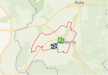
Tocht Te voet van 12,2 km beschikbaar op Noordrijn-Westfalen, Kreis Paderborn, Altenbeken. Deze tocht wordt voorgesteld door SityTrail - itinéraires balisés pédestres.
Beschrijving
Trail created by Eggegebirgsverein Schwaney.
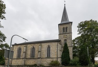
Symbol: grey silhouette of Schwaney church, surrounded by some green smbolized trees, on top of blue horizontal wavelines resembling a stream, surrounded by circular green text "Schwaneyer Panoramaweg"
Plaatsbepaling
Opmerkingen
Wandeltochten in de omgeving
![Tocht Te voet Paderborn - Walderlebnis-Pfad (Naturerbe Wanderwelt Altenbeken) - Photo](https://media.geolcdn.com/t/375/260/0d16f001-b35b-4172-b0d7-91dd2e576713.jpeg&format=jpg&maxdim=2)
![Te voet Te voet](https://static1.geolcdn.com/sitytour/trail-icons/100.png)
Te voet
![](/images/other/stat-length.png)
![](https://static1.geolcdn.com/siteimages/upload/files/16400158638029165_repeat_loop_refresh_sync_direction_icon.png)
![Tocht Te voet Paderborn - Dahl Rundweg A1 - Photo](https://media.geolcdn.com/t/375/260/37f14937-af38-4247-a5c2-932d8cd6427a.jpeg&format=jpg&maxdim=2)
![Te voet Te voet](https://static1.geolcdn.com/sitytour/trail-icons/100.png)
Te voet
![](/images/other/stat-length.png)
![](https://static1.geolcdn.com/siteimages/upload/files/16400158638029165_repeat_loop_refresh_sync_direction_icon.png)
![Tocht Te voet Paderborn - Dahler Aussichtstour - Photo](https://media.geolcdn.com/t/375/260/803a2156-810f-49e6-a52f-f1b8d804bcd3.jpeg&format=jpg&maxdim=2)
![Te voet Te voet](https://static1.geolcdn.com/sitytour/trail-icons/100.png)
Te voet
![](/images/other/stat-length.png)
![](https://static1.geolcdn.com/siteimages/upload/files/16400158638029165_repeat_loop_refresh_sync_direction_icon.png)
![Tocht Te voet Paderborn - Paderborner Karstrundweg - Photo](https://media.geolcdn.com/t/375/260/04b17e81-542a-4fe8-ba5c-31ce6461a159.jpeg&format=jpg&maxdim=2)
![Te voet Te voet](https://static1.geolcdn.com/sitytour/trail-icons/100.png)
Te voet
![](/images/other/stat-length.png)
![](https://static1.geolcdn.com/siteimages/upload/files/16400158638029165_repeat_loop_refresh_sync_direction_icon.png)
![Tocht Te voet Altenbeken - Zugangsweg Hermannshöhen - Schwaney - Photo](https://media.geolcdn.com/t/375/260/90b2059c-531a-4a47-9aba-7be4f4122425.jpeg&format=jpg&maxdim=2)
![Te voet Te voet](https://static1.geolcdn.com/sitytour/trail-icons/100.png)
Te voet
![](/images/other/stat-length.png)
![](https://static1.geolcdn.com/siteimages/upload/files/16400158638029165_repeat_loop_refresh_sync_direction_icon.png)
![Tocht Te voet Paderborn - Jühengrund - Photo](https://media.geolcdn.com/t/375/260/0d16f001-b35b-4172-b0d7-91dd2e576713.jpeg&format=jpg&maxdim=2)
![Te voet Te voet](https://static1.geolcdn.com/sitytour/trail-icons/100.png)
Te voet
![](/images/other/stat-length.png)
![](https://static1.geolcdn.com/siteimages/upload/files/16400158638029165_repeat_loop_refresh_sync_direction_icon.png)
![Tocht Te voet Paderborn - Paderborner Höhenweg - Photo](https://media.geolcdn.com/t/375/260/b5d0d3df-b18a-49ce-847b-09c83599e24d.jpeg&format=jpg&maxdim=2)
![Te voet Te voet](https://static1.geolcdn.com/sitytour/trail-icons/100.png)
Te voet
![](/images/other/stat-length.png)
![](https://static1.geolcdn.com/siteimages/upload/files/16400158638029165_repeat_loop_refresh_sync_direction_icon.png)
![Tocht Te voet Altenbeken - Dr. Hoffschulte-Weg - Photo](https://media.geolcdn.com/t/375/260/815ed2cc-9fdc-4ce9-9c65-679bf046a638.jpeg&format=jpg&maxdim=2)
![Te voet Te voet](https://static1.geolcdn.com/sitytour/trail-icons/100.png)
Te voet
![](/images/other/stat-length.png)
![](https://static1.geolcdn.com/siteimages/upload/files/16400158638029165_repeat_loop_refresh_sync_direction_icon.png)
![Tocht Te voet Paderborn - Josef-Schmitz-Weg - Photo](https://media.geolcdn.com/t/375/260/1391abc3-8b8a-42a2-8b57-344bcbcce2df.jpeg&format=jpg&maxdim=2)
![Te voet Te voet](https://static1.geolcdn.com/sitytour/trail-icons/100.png)
Te voet
![](/images/other/stat-length.png)
![](https://static1.geolcdn.com/siteimages/upload/files/16400158638029165_repeat_loop_refresh_sync_direction_icon.png)