![](/images/other/stat-length.png)
![Tocht Te voet Bad Laasphe - Ilsetalpfad - Photo](https://media.geolcdn.com/t/1900/400/ext.pjpeg?maxdim=2&url=https%3A%2F%2Fmedia.geolcdn.com%2Ff%2F59cf17ff-0b83-4dd2-b2e3-77128dff941b.jpeg)
Ilsetalpfad
SityTrail - itinéraires balisés pédestres
Tous les sentiers balisés d’Europe PRO
![Lengte](/images/other/stat-length.png)
Lengte
16,6 km
![Max. hoogte](https://static1.geolcdn.com/siteimages/upload/files/1508320355ic_sort_altitude_max_24dp.png)
Max. hoogte
613 m
![Positief hoogteverschil](https://static1.geolcdn.com/siteimages/upload/files/1508320355ic_sort_den_pos_24dp.png)
Positief hoogteverschil
485 m
![Km-Effort](/images/other/stat-length.png)
Km-Effort
23 km
![Min. hoogte](https://static1.geolcdn.com/siteimages/upload/files/1508320355ic_sort_altitude_min_24dp.png)
Min. hoogte
395 m
![Negatief hoogteverschil](https://static1.geolcdn.com/siteimages/upload/files/1508320355ic_sort_den_neg_24dp.png)
Negatief hoogteverschil
486 m
![Boucle](https://static1.geolcdn.com/siteimages/upload/files/16400158638029165_repeat_loop_refresh_sync_direction_icon.png)
Boucle
Ja
Markering
Datum van aanmaak :
2022-02-11 16:35:34.01
Laatste wijziging :
2022-02-11 16:35:34.01
![Te voet](https://static1.geolcdn.com/sitytour/trail-icons/100.png)
5h14
Moeilijkheid : Medium
![Scan deze QR-code om de tocht te openen in de SityTrail-applicatie](https://capi.geolives.com/qq0zvz2zws4bq2lad0pu/sitytour/trails/3096562/qr.png?size=200)
Gratisgps-wandelapplicatie
Over ons
Tocht Te voet van 16,6 km beschikbaar op Noordrijn-Westfalen, Kreis Siegen-Wittgenstein, Bad Laasphe. Deze tocht wordt voorgesteld door SityTrail - itinéraires balisés pédestres.
Beschrijving
Trail created by Rothaarsteigverein e.V..
Symbol: Auf der linken Seite liegendes weißes R auf schwarzem Grund
Plaatsbepaling
Land:
Germany
Regio :
Noordrijn-Westfalen
Departement/Provincie :
Kreis Siegen-Wittgenstein
Gemeente :
Bad Laasphe
Locatie:
Unknown
Vertrek:(Dec)
Vertrek:(UTM)
452248 ; 5643010 (32U) N.
Opmerkingen
Wandeltochten in de omgeving
![Tocht Te voet Bad Laasphe - Saßmannshausen Rundweg A3 - Photo](https://media.geolcdn.com/t/375/260/ext.jpg?maxdim=2&url=https%3A%2F%2Fmedia.geolcdn.com%2Ff%2Ff9a9f11f-3f3f-4bc3-a0df-be9241831f5c.jpeg)
![Te voet Te voet](https://static1.geolcdn.com/sitytour/trail-icons/100.png)
Saßmannshausen Rundweg A3
Te voet
Gemakkelijk
Bad Laasphe,
Noordrijn-Westfalen,
Kreis Siegen-Wittgenstein,
Germany
![](/images/other/stat-length.png)
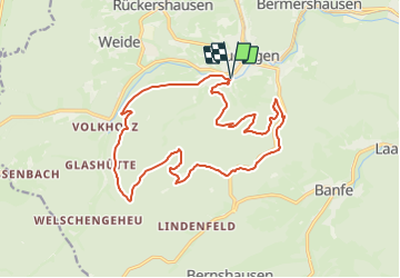
6,8 km | 10,2 km-effort
2h 18min
![](https://static1.geolcdn.com/siteimages/upload/files/16400158638029165_repeat_loop_refresh_sync_direction_icon.png)
Neen
![Tocht Te voet Bad Laasphe - östlicher Rothaarsteig-Zuweg Feudingen - Photo](https://media.geolcdn.com/t/375/260/ext.jpg?maxdim=2&url=https%3A%2F%2Fstatic1.geolcdn.com%2Fsiteimages%2Fupload%2Ffiles%2F1545311037marcheuse_200dpi.jpg)
![Te voet Te voet](https://static1.geolcdn.com/sitytour/trail-icons/100.png)
östlicher Rothaarsteig-Zuweg Feudingen
Te voet
Gemakkelijk
Bad Laasphe,
Noordrijn-Westfalen,
Kreis Siegen-Wittgenstein,
Germany
![](/images/other/stat-length.png)
6,6 km | 9,2 km-effort
2h 6min
![](https://static1.geolcdn.com/siteimages/upload/files/16400158638029165_repeat_loop_refresh_sync_direction_icon.png)
Neen