![](/images/other/stat-length.png)
![Tocht Te voet Klein-Winternheim - Panoramaweg Klein-Winternheim - Photo](https://media.geolcdn.com/t/1900/400/5d7fd195-a0ca-487d-b842-16e84861521c.jpeg&format=pjpeg&maxdim=2)
Panoramaweg Klein-Winternheim
SityTrail - itinéraires balisés pédestres
Tous les sentiers balisés d’Europe GUIDE+
![Lengte](/images/other/stat-length.png)
Lengte
3,8 km
![Max. hoogte](https://static1.geolcdn.com/siteimages/upload/files/1508320355ic_sort_altitude_max_24dp.png)
Max. hoogte
200 m
![Positief hoogteverschil](https://static1.geolcdn.com/siteimages/upload/files/1508320355ic_sort_den_pos_24dp.png)
Positief hoogteverschil
66 m
![Km-Effort](/images/other/stat-length.png)
Km-Effort
4,7 km
![Min. hoogte](https://static1.geolcdn.com/siteimages/upload/files/1508320355ic_sort_altitude_min_24dp.png)
Min. hoogte
137 m
![Negatief hoogteverschil](https://static1.geolcdn.com/siteimages/upload/files/1508320355ic_sort_den_neg_24dp.png)
Negatief hoogteverschil
66 m
![Boucle](https://static1.geolcdn.com/siteimages/upload/files/16400158638029165_repeat_loop_refresh_sync_direction_icon.png)
Boucle
Ja
Markering
Datum van aanmaak :
2022-02-11 16:23:02.759
Laatste wijziging :
2022-02-11 16:23:02.759
![Te voet](https://static1.geolcdn.com/sitytour/trail-icons/100.png)
1h03
Moeilijkheid : Gemakkelijk
![Scan deze QR-code om de tocht te openen in de SityTrail-applicatie](https://capi.geolives.com/qq0zvz2zws4bq2lad0pu/sitytour/trails/3096239/qr.png?size=200)
Gratisgps-wandelapplicatie
Over ons
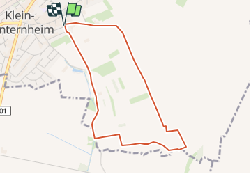
Tocht Te voet van 3,8 km beschikbaar op Rijnland-Palts, Landkreis Mainz-Bingen, Klein-Winternheim. Deze tocht wordt voorgesteld door SityTrail - itinéraires balisés pédestres.
Beschrijving
Symbol: weinrote Schilder mit einer weißen Traube
Plaatsbepaling
Land:
Germany
Regio :
Rijnland-Palts
Departement/Provincie :
Landkreis Mainz-Bingen
Gemeente :
Klein-Winternheim
Locatie:
Unknown
Vertrek:(Dec)
Vertrek:(UTM)
443800 ; 5532212 (32U) N.
Opmerkingen
Wandeltochten in de omgeving
![Tocht Te voet Nieder-Olm - Nordic Walking Nieder-Olm Nr. 6 - Photo](https://media.geolcdn.com/t/375/260/4f877ad0-4ef8-40ba-ad20-1c1b38adc4c7.jpeg&format=jpg&maxdim=2)
![Te voet Te voet](https://static1.geolcdn.com/sitytour/trail-icons/100.png)
Nordic Walking Nieder-Olm Nr. 6
Te voet
Gemakkelijk
Nieder-Olm,
Rijnland-Palts,
Landkreis Mainz-Bingen,
Germany
![](/images/other/stat-length.png)
8,5 km | 10,4 km-effort
2h 21min
![](https://static1.geolcdn.com/siteimages/upload/files/16400158638029165_repeat_loop_refresh_sync_direction_icon.png)
Ja
![Tocht Te voet Nieder-Olm - Nordic Walking Nieder-Olm Nr. 5 - Photo](https://media.geolcdn.com/t/375/260/63b79289-74ac-45f9-9b15-6214460ea3d0.jpeg&format=jpg&maxdim=2)
![Te voet Te voet](https://static1.geolcdn.com/sitytour/trail-icons/100.png)
Nordic Walking Nieder-Olm Nr. 5
Te voet
Gemakkelijk
Nieder-Olm,
Rijnland-Palts,
Landkreis Mainz-Bingen,
Germany
![](/images/other/stat-length.png)
5,7 km | 6,6 km-effort
1h 29min
![](https://static1.geolcdn.com/siteimages/upload/files/16400158638029165_repeat_loop_refresh_sync_direction_icon.png)
Ja
![Tocht Te voet Gau-Bischofsheim - Schwarzfelderweg - Photo](https://media.geolcdn.com/t/375/260/2adab82a-826f-447f-9fe1-fe346655d5ee.jpeg&format=jpg&maxdim=2)
![Te voet Te voet](https://static1.geolcdn.com/sitytour/trail-icons/100.png)
Schwarzfelderweg
Te voet
Gemakkelijk
Gau-Bischofsheim,
Rijnland-Palts,
Landkreis Mainz-Bingen,
Germany
![](/images/other/stat-length.png)
3,4 km | 3,9 km-effort
53min
![](https://static1.geolcdn.com/siteimages/upload/files/16400158638029165_repeat_loop_refresh_sync_direction_icon.png)
Ja
![Tocht Te voet Gau-Bischofsheim - Panoramaweg - Photo](https://media.geolcdn.com/t/375/260/c4763d1a-06fc-4814-a287-397c95119d27.jpeg&format=jpg&maxdim=2)
![Te voet Te voet](https://static1.geolcdn.com/sitytour/trail-icons/100.png)
Panoramaweg
Te voet
Gemakkelijk
Gau-Bischofsheim,
Rijnland-Palts,
Landkreis Mainz-Bingen,
Germany
![](/images/other/stat-length.png)
3,4 km | 4,6 km-effort
1h 2min
![](https://static1.geolcdn.com/siteimages/upload/files/16400158638029165_repeat_loop_refresh_sync_direction_icon.png)
Ja
![Tocht Te voet Klein-Winternheim - [Rotes Eichenblatt] Mainz (Hbf) - Marienborn - Zahlbach - Photo](https://media.geolcdn.com/t/375/260/29f95c8a-1e3d-4c7e-9ab0-7a1f3486a7e7.jpeg&format=jpg&maxdim=2)
![Te voet Te voet](https://static1.geolcdn.com/sitytour/trail-icons/100.png)
[Rotes Eichenblatt] Mainz (Hbf) - Marienborn - Zahlbach
Te voet
Gemakkelijk
Klein-Winternheim,
Rijnland-Palts,
Landkreis Mainz-Bingen,
Germany
![](/images/other/stat-length.png)
7,5 km | 8,2 km-effort
1h 51min
![](https://static1.geolcdn.com/siteimages/upload/files/16400158638029165_repeat_loop_refresh_sync_direction_icon.png)
Neen