![](/images/other/stat-length.png)
![Tocht Te voet Bacharach - RheinBurgenWeg Rundtour - Stahlberg-Schleife - Photo](https://media.geolcdn.com/t/1900/400/ext.pjpeg?maxdim=2&url=https%3A%2F%2Fmedia.geolcdn.com%2Ff%2F294831a9-8060-4f6d-8dd9-2f5ee93cab41.jpeg)
RheinBurgenWeg Rundtour - Stahlberg-Schleife
SityTrail - itinéraires balisés pédestres
Tous les sentiers balisés d’Europe PRO
![Lengte](/images/other/stat-length.png)
Lengte
12,8 km
![Max. hoogte](https://static1.geolcdn.com/siteimages/upload/files/1508320355ic_sort_altitude_max_24dp.png)
Max. hoogte
353 m
![Positief hoogteverschil](https://static1.geolcdn.com/siteimages/upload/files/1508320355ic_sort_den_pos_24dp.png)
Positief hoogteverschil
478 m
![Km-Effort](/images/other/stat-length.png)
Km-Effort
19,2 km
![Min. hoogte](https://static1.geolcdn.com/siteimages/upload/files/1508320355ic_sort_altitude_min_24dp.png)
Min. hoogte
94 m
![Negatief hoogteverschil](https://static1.geolcdn.com/siteimages/upload/files/1508320355ic_sort_den_neg_24dp.png)
Negatief hoogteverschil
477 m
![Boucle](https://static1.geolcdn.com/siteimages/upload/files/16400158638029165_repeat_loop_refresh_sync_direction_icon.png)
Boucle
Ja
Markering
Datum van aanmaak :
2022-02-11 16:19:34.421
Laatste wijziging :
2022-02-11 16:19:34.421
![Te voet](https://static1.geolcdn.com/sitytour/trail-icons/100.png)
4h21
Moeilijkheid : Gemakkelijk
![Scan deze QR-code om de tocht te openen in de SityTrail-applicatie](https://capi.geolives.com/qq0zvz2zws4bq2lad0pu/sitytour/trails/3096140/qr.png?size=200)
Gratisgps-wandelapplicatie
Over ons
Tocht Te voet van 12,8 km beschikbaar op Rijnland-Palts, Landkreis Mainz-Bingen, Bacharach. Deze tocht wordt voorgesteld door SityTrail - itinéraires balisés pédestres.
Beschrijving
Symbol: weiß auf rot: von den Zinnen eines Burgturmes gekröntes R
Plaatsbepaling
Land:
Germany
Regio :
Rijnland-Palts
Departement/Provincie :
Landkreis Mainz-Bingen
Gemeente :
Bacharach
Locatie:
Unknown
Vertrek:(Dec)
Vertrek:(UTM)
411570 ; 5546000 (32U) N.
Opmerkingen
Wandeltochten in de omgeving
![Tocht Te voet Lorch - In Vino Veritas - Photo](https://media.geolcdn.com/t/375/260/ext.jpg?maxdim=2&url=https%3A%2F%2Fmedia.geolcdn.com%2Ff%2F2ec29448-62c5-4cec-a4db-d5879cbe80de.jpeg)
![Te voet Te voet](https://static1.geolcdn.com/sitytour/trail-icons/100.png)
In Vino Veritas
Te voet
Gemakkelijk
Lorch,
Hessen,
Rheingau-Taunus-Kreis,
Germany
![](/images/other/stat-length.png)
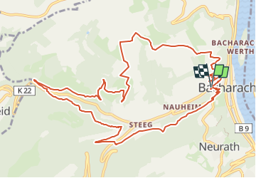
9,4 km | 13,9 km-effort
3h 9min
![](https://static1.geolcdn.com/siteimages/upload/files/16400158638029165_repeat_loop_refresh_sync_direction_icon.png)
Ja
![Tocht Te voet Lorch - Rhein-Wisper-Glück - Photo](https://media.geolcdn.com/t/375/260/ext.jpg?maxdim=2&url=https%3A%2F%2Fmedia.geolcdn.com%2Ff%2F2682c977-9daa-49b1-a7db-33c065b1c3c8.jpeg)
![Te voet Te voet](https://static1.geolcdn.com/sitytour/trail-icons/100.png)
Rhein-Wisper-Glück
Te voet
Gemakkelijk
Lorch,
Hessen,
Rheingau-Taunus-Kreis,
Germany
![](/images/other/stat-length.png)
9,3 km | 13,5 km-effort
3h 4min
![](https://static1.geolcdn.com/siteimages/upload/files/16400158638029165_repeat_loop_refresh_sync_direction_icon.png)
Ja
![Tocht Te voet Oberheimbach - Oberheimbach Panoramaweg - Photo](https://media.geolcdn.com/t/375/260/ext.jpg?maxdim=2&url=https%3A%2F%2Fmedia.geolcdn.com%2Ff%2F69ecfca3-9b8c-484e-a109-480d6d16b470.jpeg)
![Te voet Te voet](https://static1.geolcdn.com/sitytour/trail-icons/100.png)
Oberheimbach Panoramaweg
Te voet
Gemakkelijk
Oberheimbach,
Rijnland-Palts,
Landkreis Mainz-Bingen,
Germany
![](/images/other/stat-length.png)
5,5 km | 7,6 km-effort
1h 43min
![](https://static1.geolcdn.com/siteimages/upload/files/16400158638029165_repeat_loop_refresh_sync_direction_icon.png)
Neen
![Tocht Te voet Lorch - Rundwanderweg Lorch 2 - Photo](https://media.geolcdn.com/t/375/260/ext.jpg?maxdim=2&url=https%3A%2F%2Fmedia.geolcdn.com%2Ff%2F4360eda6-ffc8-4eb2-94dd-541acd72ae06.jpeg)
![Te voet Te voet](https://static1.geolcdn.com/sitytour/trail-icons/100.png)
Rundwanderweg Lorch 2
Te voet
Gemakkelijk
Lorch,
Hessen,
Rheingau-Taunus-Kreis,
Germany
![](/images/other/stat-length.png)
5,6 km | 8,3 km-effort
1h 52min
![](https://static1.geolcdn.com/siteimages/upload/files/16400158638029165_repeat_loop_refresh_sync_direction_icon.png)
Ja
![Tocht Te voet Lorch - Rundwanderweg Lorch 9 - Photo](https://media.geolcdn.com/t/375/260/ext.jpg?maxdim=2&url=https%3A%2F%2Fmedia.geolcdn.com%2Ff%2Fa7c316da-204b-44f4-b615-f5385c58b623.jpeg)
![Te voet Te voet](https://static1.geolcdn.com/sitytour/trail-icons/100.png)
Rundwanderweg Lorch 9
Te voet
Moeilijk
Lorch,
Hessen,
Rheingau-Taunus-Kreis,
Germany
![](/images/other/stat-length.png)
25 km | 34 km-effort
7h 45min
![](https://static1.geolcdn.com/siteimages/upload/files/16400158638029165_repeat_loop_refresh_sync_direction_icon.png)
Ja
![Tocht Te voet Oberdiebach - RheinBurgenWeg Rundtour - Schellengang - Photo](https://media.geolcdn.com/t/375/260/ext.jpg?maxdim=2&url=https%3A%2F%2Fmedia.geolcdn.com%2Ff%2Fab1c5980-3609-4345-84e0-20fc2d09d28e.jpeg)
![Te voet Te voet](https://static1.geolcdn.com/sitytour/trail-icons/100.png)
RheinBurgenWeg Rundtour - Schellengang
Te voet
Gemakkelijk
Oberdiebach,
Rijnland-Palts,
Landkreis Mainz-Bingen,
Germany
![](/images/other/stat-length.png)
6,4 km | 9,3 km-effort
2h 7min
![](https://static1.geolcdn.com/siteimages/upload/files/16400158638029165_repeat_loop_refresh_sync_direction_icon.png)
Neen
![Tocht Te voet Bacharach - Rundwanderweg Esel (gelber Pfeil) - Photo](https://media.geolcdn.com/t/375/260/ext.jpg?maxdim=2&url=https%3A%2F%2Fmedia.geolcdn.com%2Ff%2F2f5acfe3-b3f6-459d-979d-ff91803ae091.jpeg)
![Te voet Te voet](https://static1.geolcdn.com/sitytour/trail-icons/100.png)
Rundwanderweg Esel (gelber Pfeil)
Te voet
Gemakkelijk
Bacharach,
Rijnland-Palts,
Landkreis Mainz-Bingen,
Germany
![](/images/other/stat-length.png)
3,9 km | 5,5 km-effort
1h 14min
![](https://static1.geolcdn.com/siteimages/upload/files/16400158638029165_repeat_loop_refresh_sync_direction_icon.png)
Neen
![Tocht Te voet Lorch - Rundwanderweg Lorch 1 - Photo](https://media.geolcdn.com/t/375/260/ext.jpg?maxdim=2&url=https%3A%2F%2Fmedia.geolcdn.com%2Ff%2Fa7c316da-204b-44f4-b615-f5385c58b623.jpeg)
![Te voet Te voet](https://static1.geolcdn.com/sitytour/trail-icons/100.png)
Rundwanderweg Lorch 1
Te voet
Gemakkelijk
Lorch,
Hessen,
Rheingau-Taunus-Kreis,
Germany
![](/images/other/stat-length.png)
4,5 km | 6,4 km-effort
1h 26min
![](https://static1.geolcdn.com/siteimages/upload/files/16400158638029165_repeat_loop_refresh_sync_direction_icon.png)
Ja
![Tocht Te voet Kaub - Naturfreundeweg - Photo](https://media.geolcdn.com/t/375/260/ext.jpg?maxdim=2&url=https%3A%2F%2Fmedia.geolcdn.com%2Ff%2Fdfaf2ee2-4f34-4532-9732-e59b74662222.jpeg)
![Te voet Te voet](https://static1.geolcdn.com/sitytour/trail-icons/100.png)
Naturfreundeweg
Te voet
Gemakkelijk
Kaub,
Rijnland-Palts,
Rhein-Lahn-Kreis,
Germany
![](/images/other/stat-length.png)
8,3 km | 11,3 km-effort
2h 34min
![](https://static1.geolcdn.com/siteimages/upload/files/16400158638029165_repeat_loop_refresh_sync_direction_icon.png)
Neen