![](/images/other/stat-length.png)
![Tocht Te voet Greding - Greding 1 - Photo](https://media.geolcdn.com/t/1900/400/f07158d5-6c30-4550-a9f9-c0d68d73970a.jpeg&format=pjpeg&maxdim=2)
Greding 1
SityTrail - itinéraires balisés pédestres
Tous les sentiers balisés d’Europe GUIDE+
![Lengte](/images/other/stat-length.png)
Lengte
10,8 km
![Max. hoogte](https://static1.geolcdn.com/siteimages/upload/files/1508320355ic_sort_altitude_max_24dp.png)
Max. hoogte
539 m
![Positief hoogteverschil](https://static1.geolcdn.com/siteimages/upload/files/1508320355ic_sort_den_pos_24dp.png)
Positief hoogteverschil
230 m
![Km-Effort](/images/other/stat-length.png)
Km-Effort
13,9 km
![Min. hoogte](https://static1.geolcdn.com/siteimages/upload/files/1508320355ic_sort_altitude_min_24dp.png)
Min. hoogte
413 m
![Negatief hoogteverschil](https://static1.geolcdn.com/siteimages/upload/files/1508320355ic_sort_den_neg_24dp.png)
Negatief hoogteverschil
231 m
![Boucle](https://static1.geolcdn.com/siteimages/upload/files/16400158638029165_repeat_loop_refresh_sync_direction_icon.png)
Boucle
Ja
Markering
Datum van aanmaak :
2022-02-11 15:27:41.333
Laatste wijziging :
2022-02-11 15:27:41.333
![Te voet](https://static1.geolcdn.com/sitytour/trail-icons/100.png)
3h09
Moeilijkheid : Gemakkelijk
![Scan deze QR-code om de tocht te openen in de SityTrail-applicatie](https://capi.geolives.com/qq0zvz2zws4bq2lad0pu/sitytour/trails/3094529/qr.png?size=200)
Gratisgps-wandelapplicatie
Over ons
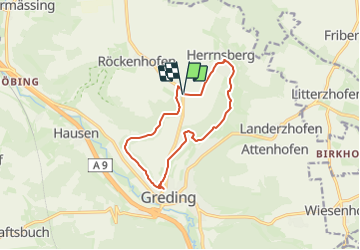
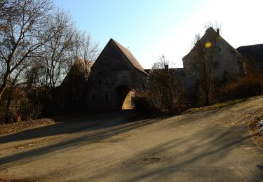
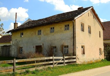
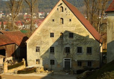
Tocht Te voet van 10,8 km beschikbaar op Beieren, Landkreis Roth, Greding. Deze tocht wordt voorgesteld door SityTrail - itinéraires balisés pédestres.
Beschrijving
Trail created by Stadt Greding.
abgeschlossen (Nov. 2013 by cycling_zno)
Symbol: Grüne 1 auf gelbem Grund
Website: https://www.greding.de/wege/premiumweg_greding-15/
Plaatsbepaling
Land:
Germany
Regio :
Beieren
Departement/Provincie :
Landkreis Roth
Gemeente :
Greding
Locatie:
Unknown
Vertrek:(Dec)
Vertrek:(UTM)
672203 ; 5437819 (32U) N.
Opmerkingen
Wandeltochten in de omgeving
![Tocht Te voet Greding - Quellenwanderweg - Photo](https://media.geolcdn.com/t/375/260/a8f46c73-b49e-4c3a-a414-5283f4fcc332.jpeg&format=jpg&maxdim=2)
![Te voet Te voet](https://static1.geolcdn.com/sitytour/trail-icons/100.png)
Quellenwanderweg
Te voet
Gemakkelijk
Greding,
Beieren,
Landkreis Roth,
Germany
![](/images/other/stat-length.png)
3,3 km | 4 km-effort
54min
![](https://static1.geolcdn.com/siteimages/upload/files/16400158638029165_repeat_loop_refresh_sync_direction_icon.png)
Neen
![Tocht Te voet Greding - Greding 10 - Photo](https://media.geolcdn.com/t/375/260/7d0199d0-165a-4e11-80c2-428d924ff058.jpeg&format=jpg&maxdim=2)
![Te voet Te voet](https://static1.geolcdn.com/sitytour/trail-icons/100.png)
Greding 10
Te voet
Gemakkelijk
Greding,
Beieren,
Landkreis Roth,
Germany
![](/images/other/stat-length.png)
11,9 km | 15,5 km-effort
3h 31min
![](https://static1.geolcdn.com/siteimages/upload/files/16400158638029165_repeat_loop_refresh_sync_direction_icon.png)
Ja
![Tocht Te voet Greding - Greding 8 - Photo](https://media.geolcdn.com/t/375/260/5a3c676f-c5c0-4229-bf92-a10cd27d57ee.jpeg&format=jpg&maxdim=2)
![Te voet Te voet](https://static1.geolcdn.com/sitytour/trail-icons/100.png)
Greding 8
Te voet
Gemakkelijk
Greding,
Beieren,
Landkreis Roth,
Germany
![](/images/other/stat-length.png)
8,1 km | 11,1 km-effort
2h 31min
![](https://static1.geolcdn.com/siteimages/upload/files/16400158638029165_repeat_loop_refresh_sync_direction_icon.png)
Ja
![Tocht Te voet Greding - Greding 6 - Photo](https://media.geolcdn.com/t/375/260/3d8e8d5f-796c-4315-bec7-7aec3e8ed1fd.jpeg&format=jpg&maxdim=2)
![Te voet Te voet](https://static1.geolcdn.com/sitytour/trail-icons/100.png)
Greding 6
Te voet
Gemakkelijk
Greding,
Beieren,
Landkreis Roth,
Germany
![](/images/other/stat-length.png)
6,9 km | 9,9 km-effort
2h 14min
![](https://static1.geolcdn.com/siteimages/upload/files/16400158638029165_repeat_loop_refresh_sync_direction_icon.png)
Ja
![Tocht Te voet Greding - Greding 5 - Photo](https://media.geolcdn.com/t/375/260/c416803e-b2fb-4be0-8c4c-d119118f5245.jpeg&format=jpg&maxdim=2)
![Te voet Te voet](https://static1.geolcdn.com/sitytour/trail-icons/100.png)
Greding 5
Te voet
Gemakkelijk
Greding,
Beieren,
Landkreis Roth,
Germany
![](/images/other/stat-length.png)
5 km | 6,1 km-effort
1h 22min
![](https://static1.geolcdn.com/siteimages/upload/files/16400158638029165_repeat_loop_refresh_sync_direction_icon.png)
Ja
![Tocht Te voet Greding - Greding 4 - Photo](https://media.geolcdn.com/t/375/260/f1936189-7d4d-4bf9-aba0-c775e147c7ad.jpeg&format=jpg&maxdim=2)
![Te voet Te voet](https://static1.geolcdn.com/sitytour/trail-icons/100.png)
Greding 4
Te voet
Gemakkelijk
Greding,
Beieren,
Landkreis Roth,
Germany
![](/images/other/stat-length.png)
7,2 km | 9,4 km-effort
2h 8min
![](https://static1.geolcdn.com/siteimages/upload/files/16400158638029165_repeat_loop_refresh_sync_direction_icon.png)
Ja
![Tocht Te voet Greding - Greding 2 - Photo](https://media.geolcdn.com/t/375/260/8a429c84-d287-454d-9696-85182cbaed09.jpeg&format=jpg&maxdim=2)
![Te voet Te voet](https://static1.geolcdn.com/sitytour/trail-icons/100.png)
Greding 2
Te voet
Gemakkelijk
Greding,
Beieren,
Landkreis Roth,
Germany
![](/images/other/stat-length.png)
4,7 km | 7,3 km-effort
1h 39min
![](https://static1.geolcdn.com/siteimages/upload/files/16400158638029165_repeat_loop_refresh_sync_direction_icon.png)
Ja
![Tocht Te voet Greding - Greding 3 - Photo](https://media.geolcdn.com/t/375/260/56b64e79-e5b2-4734-a482-9721b4bb9f96.jpeg&format=jpg&maxdim=2)
![Te voet Te voet](https://static1.geolcdn.com/sitytour/trail-icons/100.png)
Greding 3
Te voet
Gemakkelijk
Greding,
Beieren,
Landkreis Roth,
Germany
![](/images/other/stat-length.png)
3,4 km | 4,8 km-effort
1h 4min
![](https://static1.geolcdn.com/siteimages/upload/files/16400158638029165_repeat_loop_refresh_sync_direction_icon.png)
Neen