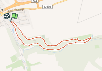
![](/images/other/stat-length.png)
![Tocht Te voet Auetal - AU1 Weg der Selbstzuwendung - Photo](https://media.geolcdn.com/t/1900/400/d843dc3f-5eda-461e-a231-23447a0c66eb.jpeg&format=pjpeg&maxdim=2)
AU1 Weg der Selbstzuwendung
SityTrail - itinéraires balisés pédestres
Tous les sentiers balisés d’Europe GUIDE+
![Lengte](/images/other/stat-length.png)
![Max. hoogte](https://static1.geolcdn.com/siteimages/upload/files/1508320355ic_sort_altitude_max_24dp.png)
![Positief hoogteverschil](https://static1.geolcdn.com/siteimages/upload/files/1508320355ic_sort_den_pos_24dp.png)
![Km-Effort](/images/other/stat-length.png)
![Min. hoogte](https://static1.geolcdn.com/siteimages/upload/files/1508320355ic_sort_altitude_min_24dp.png)
![Negatief hoogteverschil](https://static1.geolcdn.com/siteimages/upload/files/1508320355ic_sort_den_neg_24dp.png)
![Boucle](https://static1.geolcdn.com/siteimages/upload/files/16400158638029165_repeat_loop_refresh_sync_direction_icon.png)
![Te voet](https://static1.geolcdn.com/sitytour/trail-icons/100.png)
1h09
Moeilijkheid : Gemakkelijk
![Scan deze QR-code om de tocht te openen in de SityTrail-applicatie](https://capi.geolives.com/qq0zvz2zws4bq2lad0pu/sitytour/trails/3094464/qr.png?size=200)
Gratisgps-wandelapplicatie
Over ons
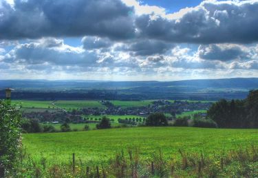
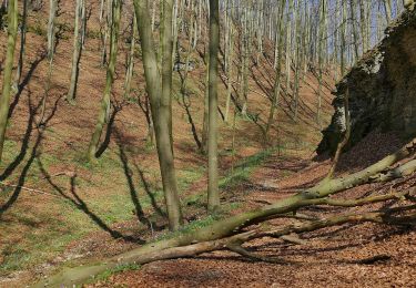
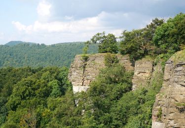
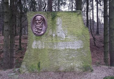
Tocht Te voet van 4,2 km beschikbaar op Nedersaksen, Landkreis Schaumburg, Auetal. Deze tocht wordt voorgesteld door SityTrail - itinéraires balisés pédestres.
Beschrijving
Symbol: blaue 1 auf gelbem Grund
Website: https://pages.et4.de/de/westliches-weserbergland_neu/default/detail/Tour/FAF22A5AB720A35974598935C48E3F51/au1-weg-der-selbstzuwendung
Plaatsbepaling
Opmerkingen
Wandeltochten in de omgeving
![Tocht Te voet Auetal - RI6 Springstein Route - Photo](https://media.geolcdn.com/t/375/260/5e0c6d99-c6ea-4662-96bc-c10b18506f59.jpeg&format=jpg&maxdim=2)
![Te voet Te voet](https://static1.geolcdn.com/sitytour/trail-icons/100.png)
Te voet
![](/images/other/stat-length.png)
![](https://static1.geolcdn.com/siteimages/upload/files/16400158638029165_repeat_loop_refresh_sync_direction_icon.png)
![Tocht Te voet Auetal - HO1 - Amelungsberg-Route - Photo](https://media.geolcdn.com/t/375/260/dea98733-fca4-4770-ba02-38d9e1c6e490.jpeg&format=jpg&maxdim=2)
![Te voet Te voet](https://static1.geolcdn.com/sitytour/trail-icons/100.png)
Te voet
![](/images/other/stat-length.png)
![](https://static1.geolcdn.com/siteimages/upload/files/16400158638029165_repeat_loop_refresh_sync_direction_icon.png)
![Tocht Te voet Auetal - RI7 Schloss-Schaumburg Route - Photo](https://media.geolcdn.com/t/375/260/75bfa630-e257-4b54-83f2-882e2b541f2d.jpeg&format=jpg&maxdim=2)
![Te voet Te voet](https://static1.geolcdn.com/sitytour/trail-icons/100.png)
Te voet
![](/images/other/stat-length.png)
![](https://static1.geolcdn.com/siteimages/upload/files/16400158638029165_repeat_loop_refresh_sync_direction_icon.png)
![Tocht Te voet Auetal - RI5 Drei Burgen Route - Photo](https://media.geolcdn.com/t/375/260/5e0c6d99-c6ea-4662-96bc-c10b18506f59.jpeg&format=jpg&maxdim=2)
![Te voet Te voet](https://static1.geolcdn.com/sitytour/trail-icons/100.png)
Te voet
![](/images/other/stat-length.png)
![](https://static1.geolcdn.com/siteimages/upload/files/16400158638029165_repeat_loop_refresh_sync_direction_icon.png)
![Tocht Te voet Auetal - HO6 - Blutbach-Route - Photo](https://media.geolcdn.com/t/375/260/e3201841-b8b9-475b-a2c8-5b835b6e5123.jpeg&format=jpg&maxdim=2)
![Te voet Te voet](https://static1.geolcdn.com/sitytour/trail-icons/100.png)
Te voet
![](/images/other/stat-length.png)
![](https://static1.geolcdn.com/siteimages/upload/files/16400158638029165_repeat_loop_refresh_sync_direction_icon.png)
![Tocht Te voet Auetal - HO2 - Schneegrund-Route - Photo](https://media.geolcdn.com/t/375/260/dea98733-fca4-4770-ba02-38d9e1c6e490.jpeg&format=jpg&maxdim=2)
![Te voet Te voet](https://static1.geolcdn.com/sitytour/trail-icons/100.png)
Te voet
![](/images/other/stat-length.png)
![](https://static1.geolcdn.com/siteimages/upload/files/16400158638029165_repeat_loop_refresh_sync_direction_icon.png)
![Tocht Te voet Auetal - HO8 - Kreuzstein-Route - Photo](https://media.geolcdn.com/t/375/260/1aeb67ea-79b2-489e-ad6a-b72fa034a647.jpeg&format=jpg&maxdim=2)
![Te voet Te voet](https://static1.geolcdn.com/sitytour/trail-icons/100.png)
Te voet
![](/images/other/stat-length.png)
![](https://static1.geolcdn.com/siteimages/upload/files/16400158638029165_repeat_loop_refresh_sync_direction_icon.png)
![Tocht Te voet Auetal - HO7 - Hohenstein Route - Photo](https://media.geolcdn.com/t/375/260/1aeb67ea-79b2-489e-ad6a-b72fa034a647.jpeg&format=jpg&maxdim=2)
![Te voet Te voet](https://static1.geolcdn.com/sitytour/trail-icons/100.png)
Te voet
![](/images/other/stat-length.png)
![](https://static1.geolcdn.com/siteimages/upload/files/16400158638029165_repeat_loop_refresh_sync_direction_icon.png)
![Tocht Te voet Auetal - Naturerlebnispfad Dinosaurierfährten Schaumburger Land - Photo](https://media.geolcdn.com/t/375/260/a231b853-3e47-4361-9062-d0dc4bcdf6e3.jpeg&format=jpg&maxdim=2)
![Te voet Te voet](https://static1.geolcdn.com/sitytour/trail-icons/100.png)
Te voet
![](/images/other/stat-length.png)
![](https://static1.geolcdn.com/siteimages/upload/files/16400158638029165_repeat_loop_refresh_sync_direction_icon.png)