![](/images/other/stat-length.png)
![Tocht Te voet Schluchsee - DE-Eselshütte - Muchenland Parkplatz - Photo](https://media.geolcdn.com/t/1900/400/ext.pjpeg?maxdim=2&url=https%3A%2F%2Fstatic1.geolcdn.com%2Fsiteimages%2Fupload%2Ffiles%2F1545311037marcheuse_200dpi.jpg)
DE-Eselshütte - Muchenland Parkplatz
SityTrail - itinéraires balisés pédestres
Tous les sentiers balisés d’Europe GUIDE+
![Lengte](/images/other/stat-length.png)
Lengte
3,1 km
![Max. hoogte](https://static1.geolcdn.com/siteimages/upload/files/1508320355ic_sort_altitude_max_24dp.png)
Max. hoogte
1090 m
![Positief hoogteverschil](https://static1.geolcdn.com/siteimages/upload/files/1508320355ic_sort_den_pos_24dp.png)
Positief hoogteverschil
21 m
![Km-Effort](/images/other/stat-length.png)
Km-Effort
3,7 km
![Min. hoogte](https://static1.geolcdn.com/siteimages/upload/files/1508320355ic_sort_altitude_min_24dp.png)
Min. hoogte
995 m
![Negatief hoogteverschil](https://static1.geolcdn.com/siteimages/upload/files/1508320355ic_sort_den_neg_24dp.png)
Negatief hoogteverschil
109 m
![Boucle](https://static1.geolcdn.com/siteimages/upload/files/16400158638029165_repeat_loop_refresh_sync_direction_icon.png)
Boucle
Neen
Markering
Datum van aanmaak :
2022-02-11 14:46:14.873
Laatste wijziging :
2022-02-11 14:46:14.873
![Te voet](https://static1.geolcdn.com/sitytour/trail-icons/100.png)
50m
Moeilijkheid : Gemakkelijk
![Scan deze QR-code om de tocht te openen in de SityTrail-applicatie](https://capi.geolives.com/qq0zvz2zws4bq2lad0pu/sitytour/trails/3093271/qr.png?size=200)
Gratisgps-wandelapplicatie
Over ons
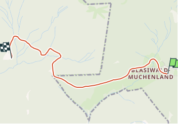
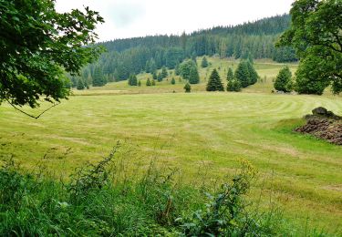
Tocht Te voet van 3,1 km beschikbaar op Baden-Württemberg, Landkreis Breisgau-Hochschwarzwald, Schluchsee. Deze tocht wordt voorgesteld door SityTrail - itinéraires balisés pédestres.
Beschrijving
Eselshütte - Muchenland Parkplatz
Symbol: gelber Diamant (waagrecht)
Plaatsbepaling
Land:
Germany
Regio :
Baden-Württemberg
Departement/Provincie :
Landkreis Breisgau-Hochschwarzwald
Gemeente :
Schluchsee
Locatie:
Blasiwald
Vertrek:(Dec)
Vertrek:(UTM)
435165 ; 5293731 (32T) N.
Opmerkingen
Wandeltochten in de omgeving
![Tocht Te voet Schluchsee - Seerundweg - Photo](https://media.geolcdn.com/t/375/260/3c949521-d45f-40b0-b8dc-66f1fcbfb52f.jpeg&format=jpg&maxdim=2)
![Te voet Te voet](https://static1.geolcdn.com/sitytour/trail-icons/100.png)
Seerundweg
Te voet
Medium
Schluchsee,
Baden-Württemberg,
Landkreis Breisgau-Hochschwarzwald,
Germany
![](/images/other/stat-length.png)
17,5 km | 21 km-effort
4h 47min
![](https://static1.geolcdn.com/siteimages/upload/files/16400158638029165_repeat_loop_refresh_sync_direction_icon.png)
Neen
![Tocht Te voet St. Blasien - St. Blasien - Höchenschwand - Photo](https://media.geolcdn.com/t/375/260/dd2bb506-95a7-4528-8a64-6b745a6d7beb.jpeg&format=jpg&maxdim=2)
![Te voet Te voet](https://static1.geolcdn.com/sitytour/trail-icons/100.png)
St. Blasien - Höchenschwand
Te voet
Gemakkelijk
St. Blasien,
Baden-Württemberg,
Landkreis Waldshut,
Germany
![](/images/other/stat-length.png)
6,3 km | 10,1 km-effort
2h 17min
![](https://static1.geolcdn.com/siteimages/upload/files/16400158638029165_repeat_loop_refresh_sync_direction_icon.png)
Neen
![Tocht Te voet Schluchsee - Aha - Altglashütten - Photo](https://media.geolcdn.com/t/375/260/fbef3630-0250-410c-a6a1-80448ac48f09.jpeg&format=jpg&maxdim=2)
![Te voet Te voet](https://static1.geolcdn.com/sitytour/trail-icons/100.png)
Aha - Altglashütten
Te voet
Gemakkelijk
Schluchsee,
Baden-Württemberg,
Landkreis Breisgau-Hochschwarzwald,
Germany
![](/images/other/stat-length.png)
4 km | 5,1 km-effort
1h 9min
![](https://static1.geolcdn.com/siteimages/upload/files/16400158638029165_repeat_loop_refresh_sync_direction_icon.png)
Neen
![Tocht Te voet Schluchsee - Jägersteig - Photo](https://media.geolcdn.com/t/375/260/e6618854-799a-4113-a147-f68601b347d5.jpeg&format=jpg&maxdim=2)
![Te voet Te voet](https://static1.geolcdn.com/sitytour/trail-icons/100.png)
Jägersteig
Te voet
Gemakkelijk
Schluchsee,
Baden-Württemberg,
Landkreis Breisgau-Hochschwarzwald,
Germany
![](/images/other/stat-length.png)
11,6 km | 15,8 km-effort
3h 35min
![](https://static1.geolcdn.com/siteimages/upload/files/16400158638029165_repeat_loop_refresh_sync_direction_icon.png)
Ja
![Tocht Te voet Schluchsee - DE-Ehemalige Krummensäge - Kohlhütte - fixme - Photo](https://media.geolcdn.com/t/375/260/00edd11d-5774-4c7d-84eb-be79de7d632d.jpeg&format=jpg&maxdim=2)
![Te voet Te voet](https://static1.geolcdn.com/sitytour/trail-icons/100.png)
DE-Ehemalige Krummensäge - Kohlhütte - fixme
Te voet
Gemakkelijk
Schluchsee,
Baden-Württemberg,
Landkreis Breisgau-Hochschwarzwald,
Germany
![](/images/other/stat-length.png)
3,1 km | 3,6 km-effort
49min
![](https://static1.geolcdn.com/siteimages/upload/files/16400158638029165_repeat_loop_refresh_sync_direction_icon.png)
Neen
![Tocht Te voet St. Blasien - St. Blasien - Farnwitte - Photo](https://media.geolcdn.com/t/375/260/09e36bd8-d689-4eac-b51e-56f2a9bb44ed.jpeg&format=jpg&maxdim=2)
![Te voet Te voet](https://static1.geolcdn.com/sitytour/trail-icons/100.png)
St. Blasien - Farnwitte
Te voet
Medium
St. Blasien,
Baden-Württemberg,
Landkreis Waldshut,
Germany
![](/images/other/stat-length.png)
15,9 km | 23 km-effort
5h 17min
![](https://static1.geolcdn.com/siteimages/upload/files/16400158638029165_repeat_loop_refresh_sync_direction_icon.png)
Neen
![Tocht Te voet Schluchsee - DE-Muchenländer Brücke - Schubenwald - Photo](https://media.geolcdn.com/t/375/260/3870eac4-99dd-48db-b536-97eebeedc4f9.jpeg&format=jpg&maxdim=2)
![Te voet Te voet](https://static1.geolcdn.com/sitytour/trail-icons/100.png)
DE-Muchenländer Brücke - Schubenwald
Te voet
Gemakkelijk
Schluchsee,
Baden-Württemberg,
Landkreis Breisgau-Hochschwarzwald,
Germany
![](/images/other/stat-length.png)
4 km | 6,9 km-effort
1h 33min
![](https://static1.geolcdn.com/siteimages/upload/files/16400158638029165_repeat_loop_refresh_sync_direction_icon.png)
Neen
![Tocht Stappen Schluchsee - Forêt Noire : tour du lac Schluchsee - Photo](https://media.geolcdn.com/t/375/260/4bd1242a-de17-40e1-bef7-3804b25aa960.jpg&format=jpg&maxdim=2)
![Stappen Stappen](https://static1.geolcdn.com/sitytour/trail-icons/101.png)
Forêt Noire : tour du lac Schluchsee
Stappen
Zeer moeilijk
Schluchsee,
Baden-Württemberg,
Landkreis Breisgau-Hochschwarzwald,
Germany
![](/images/other/stat-length.png)
17,7 km | 21 km-effort
4h 49min
![](https://static1.geolcdn.com/siteimages/upload/files/16400158638029165_repeat_loop_refresh_sync_direction_icon.png)
Ja
![Tocht Stappen Schluchsee - Schluchsee - Photo](https://media.geolcdn.com/t/375/260/fd30626f-f2de-4b12-82e2-d6596e2d9d5f.jpg&format=jpg&maxdim=2)
![Stappen Stappen](https://static1.geolcdn.com/sitytour/trail-icons/101.png)
Schluchsee
Stappen
Heel gemakkelijk
Schluchsee,
Baden-Württemberg,
Landkreis Breisgau-Hochschwarzwald,
Germany
![](/images/other/stat-length.png)
5,7 km | 6,5 km-effort
1h 45min
![](https://static1.geolcdn.com/siteimages/upload/files/16400158638029165_repeat_loop_refresh_sync_direction_icon.png)
Ja