![](/images/other/stat-length.png)
![Tocht Te voet Onbekend - Wanderweg A-H - Photo](https://media.geolcdn.com/t/1900/400/ext.pjpeg?maxdim=2&url=https%3A%2F%2Fmedia.geolcdn.com%2Ff%2Ff4a1f4e9-fd23-4f77-a0e3-1b351d02f82e.jpeg)
Wanderweg A-H
SityTrail - itinéraires balisés pédestres
Tous les sentiers balisés d’Europe PRO
![Lengte](/images/other/stat-length.png)
Lengte
6,3 km
![Max. hoogte](https://static1.geolcdn.com/siteimages/upload/files/1508320355ic_sort_altitude_max_24dp.png)
Max. hoogte
86 m
![Positief hoogteverschil](https://static1.geolcdn.com/siteimages/upload/files/1508320355ic_sort_den_pos_24dp.png)
Positief hoogteverschil
116 m
![Km-Effort](/images/other/stat-length.png)
Km-Effort
7,6 km
![Min. hoogte](https://static1.geolcdn.com/siteimages/upload/files/1508320355ic_sort_altitude_min_24dp.png)
Min. hoogte
10 m
![Negatief hoogteverschil](https://static1.geolcdn.com/siteimages/upload/files/1508320355ic_sort_den_neg_24dp.png)
Negatief hoogteverschil
46 m
![Boucle](https://static1.geolcdn.com/siteimages/upload/files/16400158638029165_repeat_loop_refresh_sync_direction_icon.png)
Boucle
Neen
Markering
Datum van aanmaak :
2022-02-11 14:42:21.9
Laatste wijziging :
2022-02-11 14:42:21.9
![Te voet](https://static1.geolcdn.com/sitytour/trail-icons/100.png)
1h44
Moeilijkheid : Gemakkelijk
![Scan deze QR-code om de tocht te openen in de SityTrail-applicatie](https://capi.geolives.com/qq0zvz2zws4bq2lad0pu/sitytour/trails/3093153/qr.png?size=200)
Gratisgps-wandelapplicatie
Over ons
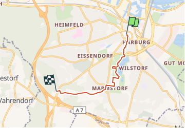
Tocht Te voet van 6,3 km beschikbaar op Hamburg, Onbekend, Onbekend. Deze tocht wordt voorgesteld door SityTrail - itinéraires balisés pédestres.
Beschrijving
Trail created by Wanderverband Norddeutschland e.V..
Symbol: gelber Pfeil auf weissem Grund
Website: http://www.wanderverband-norddeutschland.de
Plaatsbepaling
Land:
Germany
Regio :
Hamburg
Departement/Provincie :
Onbekend
Gemeente :
Onbekend
Locatie:
Harburg
Vertrek:(Dec)
Vertrek:(UTM)
565122 ; 5923867 (32U) N.
Opmerkingen
Wandeltochten in de omgeving
![Tocht Te voet Onbekend - Wanderweg Verbindungsweg HF-H - Photo](https://media.geolcdn.com/t/375/260/ext.jpg?maxdim=2&url=https%3A%2F%2Fmedia.geolcdn.com%2Ff%2F456ffa5a-8bbe-4077-905c-65704ac5cb42.jpeg)
![Te voet Te voet](https://static1.geolcdn.com/sitytour/trail-icons/100.png)
Wanderweg Verbindungsweg HF-H
Te voet
Gemakkelijk
Onbekend,
Hamburg,
Onbekend,
Germany
![](/images/other/stat-length.png)
4,4 km | 5,3 km-effort
1h 11min
![](https://static1.geolcdn.com/siteimages/upload/files/16400158638029165_repeat_loop_refresh_sync_direction_icon.png)
Neen
![Tocht Te voet Onbekend - Wander-Tour Harburger Berge - Photo](https://media.geolcdn.com/t/375/260/ext.jpg?maxdim=2&url=https%3A%2F%2Fmedia.geolcdn.com%2Ff%2F69152109-3ce8-403e-943f-dd0414299b48.jpeg)
![Te voet Te voet](https://static1.geolcdn.com/sitytour/trail-icons/100.png)
Wander-Tour Harburger Berge
Te voet
Gemakkelijk
Onbekend,
Hamburg,
Onbekend,
Germany
![](/images/other/stat-length.png)
4,4 km | 5,4 km-effort
1h 13min
![](https://static1.geolcdn.com/siteimages/upload/files/16400158638029165_repeat_loop_refresh_sync_direction_icon.png)
Neen
![Tocht Te voet Onbekend - Wanderweg KI-A - Photo](https://media.geolcdn.com/t/375/260/ext.jpg?maxdim=2&url=https%3A%2F%2Fmedia.geolcdn.com%2Ff%2Ff4a1f4e9-fd23-4f77-a0e3-1b351d02f82e.jpeg)
![Te voet Te voet](https://static1.geolcdn.com/sitytour/trail-icons/100.png)
Wanderweg KI-A
Te voet
Gemakkelijk
Onbekend,
Hamburg,
Onbekend,
Germany
![](/images/other/stat-length.png)
4,6 km | 5,6 km-effort
1h 15min
![](https://static1.geolcdn.com/siteimages/upload/files/16400158638029165_repeat_loop_refresh_sync_direction_icon.png)
Neen
![Tocht Te voet Onbekend - Wanderweg KA-A - Photo](https://media.geolcdn.com/t/375/260/ext.jpg?maxdim=2&url=https%3A%2F%2Fmedia.geolcdn.com%2Ff%2F6754b8db-6acb-4b11-b2da-87c0475c0759.jpeg)
![Te voet Te voet](https://static1.geolcdn.com/sitytour/trail-icons/100.png)
Wanderweg KA-A
Te voet
Gemakkelijk
Onbekend,
Hamburg,
Onbekend,
Germany
![](/images/other/stat-length.png)
9,5 km | 11,4 km-effort
2h 35min
![](https://static1.geolcdn.com/siteimages/upload/files/16400158638029165_repeat_loop_refresh_sync_direction_icon.png)
Neen
![Tocht Te voet Onbekend - Wanderweg 24 - Photo](https://media.geolcdn.com/t/375/260/ext.jpg?maxdim=2&url=https%3A%2F%2Fmedia.geolcdn.com%2Ff%2F03744dda-f212-4e90-978c-ba8799e67dad.jpeg)
![Te voet Te voet](https://static1.geolcdn.com/sitytour/trail-icons/100.png)
Wanderweg 24
Te voet
Gemakkelijk
Onbekend,
Hamburg,
Onbekend,
Germany
![](/images/other/stat-length.png)
15,3 km | 18,5 km-effort
4h 11min
![](https://static1.geolcdn.com/siteimages/upload/files/16400158638029165_repeat_loop_refresh_sync_direction_icon.png)
Neen
![Tocht Te voet Onbekend - Wanderweg 23 - Photo](https://media.geolcdn.com/t/375/260/ext.jpg?maxdim=2&url=https%3A%2F%2Fmedia.geolcdn.com%2Ff%2F03744dda-f212-4e90-978c-ba8799e67dad.jpeg)
![Te voet Te voet](https://static1.geolcdn.com/sitytour/trail-icons/100.png)
Wanderweg 23
Te voet
Gemakkelijk
Onbekend,
Hamburg,
Onbekend,
Germany
![](/images/other/stat-length.png)
6,7 km | 8,5 km-effort
1h 55min
![](https://static1.geolcdn.com/siteimages/upload/files/16400158638029165_repeat_loop_refresh_sync_direction_icon.png)
Neen
![Tocht Te voet Seevetal - Wanderweg RB - Photo](https://media.geolcdn.com/t/375/260/ext.jpg?maxdim=2&url=https%3A%2F%2Fmedia.geolcdn.com%2Ff%2Fe4c11625-58d8-4d36-a6b3-af711ad1adc0.jpeg)
![Te voet Te voet](https://static1.geolcdn.com/sitytour/trail-icons/100.png)
Wanderweg RB
Te voet
Gemakkelijk
Seevetal,
Nedersaksen,
Harburg,
Germany
![](/images/other/stat-length.png)
6,3 km | 6,7 km-effort
1h 31min
![](https://static1.geolcdn.com/siteimages/upload/files/16400158638029165_repeat_loop_refresh_sync_direction_icon.png)
Neen
![Tocht Te voet Onbekend - Stadtscheide - Photo](https://media.geolcdn.com/t/375/260/ext.jpg?maxdim=2&url=https%3A%2F%2Fmedia.geolcdn.com%2Ff%2Ff0e265c3-8db3-4fd9-aa11-4f9215289a1f.jpeg)
![Te voet Te voet](https://static1.geolcdn.com/sitytour/trail-icons/100.png)
Stadtscheide
Te voet
Gemakkelijk
Onbekend,
Hamburg,
Onbekend,
Germany
![](/images/other/stat-length.png)
3,2 km | 4 km-effort
55min
![](https://static1.geolcdn.com/siteimages/upload/files/16400158638029165_repeat_loop_refresh_sync_direction_icon.png)
Neen
![Tocht sport Seevetal - Wanderparkplatz - Photo](https://media.geolcdn.com/t/375/260/ext.jpg?maxdim=2&url=https%3A%2F%2Fsecurestorage.geolives.com%2Fsitytour%2Ftrail-bg%2Fdefault.jpg)
Wanderparkplatz
sport
Heel gemakkelijk
Seevetal,
Nedersaksen,
Harburg,
Germany
![](/images/other/stat-length.png)
12,9 km | 15,5 km-effort
Onbekend
![](https://static1.geolcdn.com/siteimages/upload/files/16400158638029165_repeat_loop_refresh_sync_direction_icon.png)
Neen