![](/images/other/stat-length.png)
![Tocht Te voet Brennberg - Goldsteigzubringer Höllbachtal - Photo](https://media.geolcdn.com/t/1900/400/b66b4f86-9a24-44fe-8dae-326bf882b2f0.jpeg&format=pjpeg&maxdim=2)
Goldsteigzubringer Höllbachtal
SityTrail - itinéraires balisés pédestres
Tous les sentiers balisés d’Europe GUIDE+
![Lengte](/images/other/stat-length.png)
![Max. hoogte](https://static1.geolcdn.com/siteimages/upload/files/1508320355ic_sort_altitude_max_24dp.png)
![Positief hoogteverschil](https://static1.geolcdn.com/siteimages/upload/files/1508320355ic_sort_den_pos_24dp.png)
![Km-Effort](/images/other/stat-length.png)
![Min. hoogte](https://static1.geolcdn.com/siteimages/upload/files/1508320355ic_sort_altitude_min_24dp.png)
![Negatief hoogteverschil](https://static1.geolcdn.com/siteimages/upload/files/1508320355ic_sort_den_neg_24dp.png)
![Boucle](https://static1.geolcdn.com/siteimages/upload/files/16400158638029165_repeat_loop_refresh_sync_direction_icon.png)
![Te voet](https://static1.geolcdn.com/sitytour/trail-icons/100.png)
1h17
Moeilijkheid : Gemakkelijk
![Scan deze QR-code om de tocht te openen in de SityTrail-applicatie](https://capi.geolives.com/qq0zvz2zws4bq2lad0pu/sitytour/trails/3092864/qr.png?size=200)
Gratisgps-wandelapplicatie
Over ons
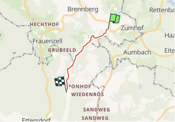
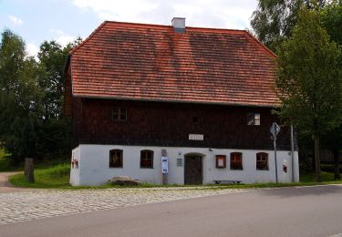
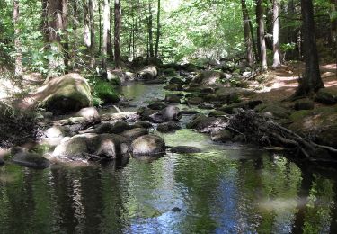
Tocht Te voet van 4,6 km beschikbaar op Beieren, Landkreis Regensburg, Brennberg. Deze tocht wordt voorgesteld door SityTrail - itinéraires balisés pédestres.
Beschrijving
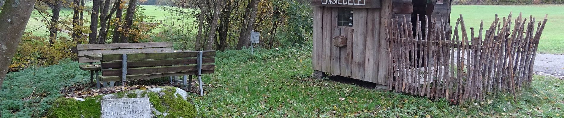
FIXME: Bitte hilf mit, alle Wegsegmente erfassen.
Symbol: Blauer, stilisierter s-förmiger Weg und schwarze Schrift "GOLDSTEIG" auf weißem, rechteckigen Grund
Plaatsbepaling
Opmerkingen
Wandeltochten in de omgeving
![Tocht Te voet Brennberg - T 8 Frauenzell - Breitenstein - Kruckenberg - Photo](https://media.geolcdn.com/t/375/260/76ab2507-fb3f-4eb5-aff2-71bc088be386.jpeg&format=jpg&maxdim=2)
![Te voet Te voet](https://static1.geolcdn.com/sitytour/trail-icons/100.png)
Te voet
![](/images/other/stat-length.png)
![](https://static1.geolcdn.com/siteimages/upload/files/16400158638029165_repeat_loop_refresh_sync_direction_icon.png)
![Tocht Te voet Brennberg - T 6 Frauenzell - Bach/Do. - Photo](https://media.geolcdn.com/t/375/260/76ab2507-fb3f-4eb5-aff2-71bc088be386.jpeg&format=jpg&maxdim=2)
![Te voet Te voet](https://static1.geolcdn.com/sitytour/trail-icons/100.png)
Te voet
![](/images/other/stat-length.png)
![](https://static1.geolcdn.com/siteimages/upload/files/16400158638029165_repeat_loop_refresh_sync_direction_icon.png)
![Tocht Te voet Brennberg - T 1 Frauenzell - Hammermühle - Photo](https://media.geolcdn.com/t/375/260/76ab2507-fb3f-4eb5-aff2-71bc088be386.jpeg&format=jpg&maxdim=2)
![Te voet Te voet](https://static1.geolcdn.com/sitytour/trail-icons/100.png)
Te voet
![](/images/other/stat-length.png)
![](https://static1.geolcdn.com/siteimages/upload/files/16400158638029165_repeat_loop_refresh_sync_direction_icon.png)
![Tocht Te voet Wiesent - O 50 Wiesent - Gfäll (Rotes Dreieck) - Photo](https://media.geolcdn.com/t/375/260/b66b4f86-9a24-44fe-8dae-326bf882b2f0.jpeg&format=jpg&maxdim=2)
![Te voet Te voet](https://static1.geolcdn.com/sitytour/trail-icons/100.png)
Te voet
![](/images/other/stat-length.png)
![](https://static1.geolcdn.com/siteimages/upload/files/16400158638029165_repeat_loop_refresh_sync_direction_icon.png)
![Tocht Te voet Brennberg - O 53 Höllbachtal - Frauenzell (Grünes Rechteck) - Photo](https://media.geolcdn.com/t/375/260/25632bcf-ab56-47c3-b425-f55cbac61b12.jpeg&format=jpg&maxdim=2)
![Te voet Te voet](https://static1.geolcdn.com/sitytour/trail-icons/100.png)
Te voet
![](/images/other/stat-length.png)
![](https://static1.geolcdn.com/siteimages/upload/files/16400158638029165_repeat_loop_refresh_sync_direction_icon.png)
![Tocht Te voet Rettenbach - Wilder Mann 149, Naturpark Vorderer Bayerischer Wald - Photo](https://media.geolcdn.com/t/375/260/530773e7-0c8c-4fad-ab0c-c5185028f559.jpeg&format=jpg&maxdim=2)
![Te voet Te voet](https://static1.geolcdn.com/sitytour/trail-icons/100.png)
Te voet
![](/images/other/stat-length.png)
![](https://static1.geolcdn.com/siteimages/upload/files/16400158638029165_repeat_loop_refresh_sync_direction_icon.png)
![Tocht Te voet Rettenbach - Rundweg Hölle - Photo](https://media.geolcdn.com/t/375/260/341294d3-5eda-4b50-a960-3eb760a86047.jpeg&format=jpg&maxdim=2)
![Te voet Te voet](https://static1.geolcdn.com/sitytour/trail-icons/100.png)
Te voet
![](/images/other/stat-length.png)
![](https://static1.geolcdn.com/siteimages/upload/files/16400158638029165_repeat_loop_refresh_sync_direction_icon.png)
![Tocht Te voet Brennberg - O 61 Frauenzell - Altenthann (Rotes Rechteck) - Photo](https://media.geolcdn.com/t/375/260/ext.jpg?maxdim=2&url=https%3A%2F%2Fstatic1.geolcdn.com%2Fsiteimages%2Fupload%2Ffiles%2F1545311037marcheuse_200dpi.jpg)
![Te voet Te voet](https://static1.geolcdn.com/sitytour/trail-icons/100.png)
Te voet
![](/images/other/stat-length.png)
![](https://static1.geolcdn.com/siteimages/upload/files/16400158638029165_repeat_loop_refresh_sync_direction_icon.png)
![Tocht Te voet Falkenstein - Wilder Mann 114 »Mariensteinweg«, Naturpark Vorderer Bayerischer Wald - Photo](https://media.geolcdn.com/t/375/260/ext.jpg?maxdim=2&url=https%3A%2F%2Fstatic1.geolcdn.com%2Fsiteimages%2Fupload%2Ffiles%2F1545311037marcheuse_200dpi.jpg)
![Te voet Te voet](https://static1.geolcdn.com/sitytour/trail-icons/100.png)
Te voet
![](/images/other/stat-length.png)
![](https://static1.geolcdn.com/siteimages/upload/files/16400158638029165_repeat_loop_refresh_sync_direction_icon.png)