![](/images/other/stat-length.png)
![Tocht Te voet Wannweil - Rund um Wannweil - Photo](https://media.geolcdn.com/t/1900/400/ext.pjpeg?maxdim=2&url=https%3A%2F%2Fmedia.geolcdn.com%2Ff%2Fc5d8f6cb-12ab-4efd-94ef-eba08f6e7146.jpeg)
Rund um Wannweil
SityTrail - itinéraires balisés pédestres
Tous les sentiers balisés d’Europe PRO
![Lengte](/images/other/stat-length.png)
Lengte
11,8 km
![Max. hoogte](https://static1.geolcdn.com/siteimages/upload/files/1508320355ic_sort_altitude_max_24dp.png)
Max. hoogte
408 m
![Positief hoogteverschil](https://static1.geolcdn.com/siteimages/upload/files/1508320355ic_sort_den_pos_24dp.png)
Positief hoogteverschil
235 m
![Km-Effort](/images/other/stat-length.png)
Km-Effort
14,9 km
![Min. hoogte](https://static1.geolcdn.com/siteimages/upload/files/1508320355ic_sort_altitude_min_24dp.png)
Min. hoogte
316 m
![Negatief hoogteverschil](https://static1.geolcdn.com/siteimages/upload/files/1508320355ic_sort_den_neg_24dp.png)
Negatief hoogteverschil
236 m
![Boucle](https://static1.geolcdn.com/siteimages/upload/files/16400158638029165_repeat_loop_refresh_sync_direction_icon.png)
Boucle
Ja
Markering
Datum van aanmaak :
2022-02-11 14:28:39.706
Laatste wijziging :
2022-02-11 14:28:39.706
![Te voet](https://static1.geolcdn.com/sitytour/trail-icons/100.png)
3h23
Moeilijkheid : Gemakkelijk
![Scan deze QR-code om de tocht te openen in de SityTrail-applicatie](https://capi.geolives.com/qq0zvz2zws4bq2lad0pu/sitytour/trails/3092667/qr.png?size=200)
Gratisgps-wandelapplicatie
Over ons
Tocht Te voet van 11,8 km beschikbaar op Baden-Württemberg, Landkreis Reutlingen, Wannweil. Deze tocht wordt voorgesteld door SityTrail - itinéraires balisés pédestres.
Beschrijving
Trail created by Ortsgruppe Wannweil des Schwäbischen Albvereins.
Website: http://www.sav-wannweil.de/wanderweg
Plaatsbepaling
Land:
Germany
Regio :
Baden-Württemberg
Departement/Provincie :
Landkreis Reutlingen
Gemeente :
Wannweil
Locatie:
Unknown
Vertrek:(Dec)
Vertrek:(UTM)
510786 ; 5373051 (32U) N.
Opmerkingen
Wandeltochten in de omgeving
![Tocht Te voet Reutlingen - Betzingen-Breitenbach-Ruoffseck - Photo](https://media.geolcdn.com/t/375/260/ext.jpg?maxdim=2&url=https%3A%2F%2Fmedia.geolcdn.com%2Ff%2Fc5d8f6cb-12ab-4efd-94ef-eba08f6e7146.jpeg)
![Te voet Te voet](https://static1.geolcdn.com/sitytour/trail-icons/100.png)
Betzingen-Breitenbach-Ruoffseck
Te voet
Gemakkelijk
Reutlingen,
Baden-Württemberg,
Landkreis Reutlingen,
Germany
![](/images/other/stat-length.png)
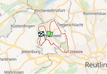
7,6 km | 10,3 km-effort
2h 20min
![](https://static1.geolcdn.com/siteimages/upload/files/16400158638029165_repeat_loop_refresh_sync_direction_icon.png)
Neen
![Tocht Te voet Reutlingen - Om Sickahausa rondrom - Photo](https://media.geolcdn.com/t/375/260/ext.jpg?maxdim=2&url=https%3A%2F%2Fmedia.geolcdn.com%2Ff%2F571f3746-024e-453a-a73d-a792f6b4e642.jpeg)
![Te voet Te voet](https://static1.geolcdn.com/sitytour/trail-icons/100.png)
Om Sickahausa rondrom
Te voet
Gemakkelijk
Reutlingen,
Baden-Württemberg,
Landkreis Reutlingen,
Germany
![](/images/other/stat-length.png)
7,2 km | 8,3 km-effort
1h 53min
![](https://static1.geolcdn.com/siteimages/upload/files/16400158638029165_repeat_loop_refresh_sync_direction_icon.png)
Neen
![Tocht Te voet Reutlingen - Rund um Ohmenhausen - Photo](https://media.geolcdn.com/t/375/260/ext.jpg?maxdim=2&url=https%3A%2F%2Fmedia.geolcdn.com%2Ff%2F20b62a2d-d3c9-4dbb-a982-b21632a6eb7a.jpeg)
![Te voet Te voet](https://static1.geolcdn.com/sitytour/trail-icons/100.png)
Rund um Ohmenhausen
Te voet
Gemakkelijk
Reutlingen,
Baden-Württemberg,
Landkreis Reutlingen,
Germany
![](/images/other/stat-length.png)
10,4 km | 12,8 km-effort
2h 55min
![](https://static1.geolcdn.com/siteimages/upload/files/16400158638029165_repeat_loop_refresh_sync_direction_icon.png)
Ja
![Tocht Te voet Reutlingen - hochgehwachsen - Photo](https://media.geolcdn.com/t/375/260/ext.jpg?maxdim=2&url=https%3A%2F%2Fstatic1.geolcdn.com%2Fsiteimages%2Fupload%2Ffiles%2F1545311037marcheuse_200dpi.jpg)
![Te voet Te voet](https://static1.geolcdn.com/sitytour/trail-icons/100.png)
hochgehwachsen
Te voet
Gemakkelijk
Reutlingen,
Baden-Württemberg,
Landkreis Reutlingen,
Germany
![](/images/other/stat-length.png)
5,4 km | 6,8 km-effort
1h 32min
![](https://static1.geolcdn.com/siteimages/upload/files/16400158638029165_repeat_loop_refresh_sync_direction_icon.png)
Neen