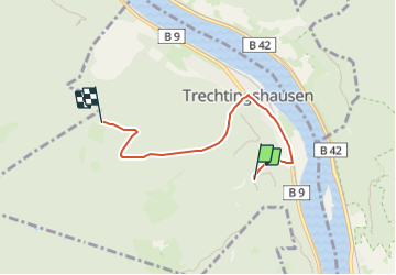
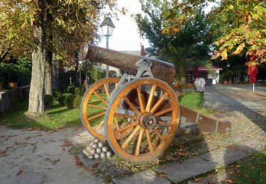
![](/images/other/stat-length.png)
![Tocht Te voet Trechtingshausen - Rheinburgenweg Zugangsweg Trechtingshausen - Photo](https://media.geolcdn.com/t/1900/400/47513b47-8600-4126-93f9-4283300ea9ba.jpeg&format=pjpeg&maxdim=2)
Rheinburgenweg Zugangsweg Trechtingshausen
SityTrail - itinéraires balisés pédestres
Tous les sentiers balisés d’Europe GUIDE+
![Lengte](/images/other/stat-length.png)
![Max. hoogte](https://static1.geolcdn.com/siteimages/upload/files/1508320355ic_sort_altitude_max_24dp.png)
![Positief hoogteverschil](https://static1.geolcdn.com/siteimages/upload/files/1508320355ic_sort_den_pos_24dp.png)
![Km-Effort](/images/other/stat-length.png)
![Min. hoogte](https://static1.geolcdn.com/siteimages/upload/files/1508320355ic_sort_altitude_min_24dp.png)
![Negatief hoogteverschil](https://static1.geolcdn.com/siteimages/upload/files/1508320355ic_sort_den_neg_24dp.png)
![Boucle](https://static1.geolcdn.com/siteimages/upload/files/16400158638029165_repeat_loop_refresh_sync_direction_icon.png)
![Te voet](https://static1.geolcdn.com/sitytour/trail-icons/100.png)
1h49
Moeilijkheid : Gemakkelijk
![Scan deze QR-code om de tocht te openen in de SityTrail-applicatie](https://capi.geolives.com/qq0zvz2zws4bq2lad0pu/sitytour/trails/3092492/qr.png?size=200)
Gratisgps-wandelapplicatie
Over ons
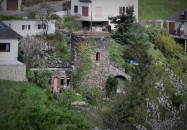
Tocht Te voet van 4,1 km beschikbaar op Rijnland-Palts, Landkreis Mainz-Bingen, Trechtingshausen. Deze tocht wordt voorgesteld door SityTrail - itinéraires balisés pédestres.
Beschrijving
Präsentiert die touristischen Angebote zwischen Rüdesheim und Bingen im Süden und dem Beginn des Siebengebirges im Norden.
Website: https://www.rheinburgenweg.com/
Plaatsbepaling
Opmerkingen
Wandeltochten in de omgeving
![Tocht Te voet Lorch - In Vino Veritas - Photo](https://media.geolcdn.com/t/375/260/2ec29448-62c5-4cec-a4db-d5879cbe80de.jpeg&format=jpg&maxdim=2)
![Te voet Te voet](https://static1.geolcdn.com/sitytour/trail-icons/100.png)
Te voet
![](/images/other/stat-length.png)
![](https://static1.geolcdn.com/siteimages/upload/files/16400158638029165_repeat_loop_refresh_sync_direction_icon.png)
![Tocht Te voet Rüdesheim am Rhein - Rheingauer Klostersteig Zuweg Assmannshausen - Photo](https://media.geolcdn.com/t/375/260/0b549e65-574a-4424-acfe-276db4f7f1c5.jpeg&format=jpg&maxdim=2)
![Te voet Te voet](https://static1.geolcdn.com/sitytour/trail-icons/100.png)
Te voet
![](/images/other/stat-length.png)
![](https://static1.geolcdn.com/siteimages/upload/files/16400158638029165_repeat_loop_refresh_sync_direction_icon.png)
![Tocht Te voet Rüdesheim am Rhein - Hildegardweg - Photo](https://media.geolcdn.com/t/375/260/383cc12c-ca7c-4bec-bb31-c2bbae795e1e.jpeg&format=jpg&maxdim=2)
![Te voet Te voet](https://static1.geolcdn.com/sitytour/trail-icons/100.png)
Te voet
![](/images/other/stat-length.png)
![](https://static1.geolcdn.com/siteimages/upload/files/16400158638029165_repeat_loop_refresh_sync_direction_icon.png)
![Tocht Te voet Rüdesheim am Rhein - Rundwanderweg Tanne - Photo](https://media.geolcdn.com/t/375/260/b5a53c37-4f34-4e66-bcaa-ee150b2ee425.jpeg&format=jpg&maxdim=2)
![Te voet Te voet](https://static1.geolcdn.com/sitytour/trail-icons/100.png)
Te voet
![](/images/other/stat-length.png)
![](https://static1.geolcdn.com/siteimages/upload/files/16400158638029165_repeat_loop_refresh_sync_direction_icon.png)
![Tocht Te voet Rüdesheim am Rhein - Rundwanderweg Reh - Photo](https://media.geolcdn.com/t/375/260/b5a53c37-4f34-4e66-bcaa-ee150b2ee425.jpeg&format=jpg&maxdim=2)
![Te voet Te voet](https://static1.geolcdn.com/sitytour/trail-icons/100.png)
Te voet
![](/images/other/stat-length.png)
![](https://static1.geolcdn.com/siteimages/upload/files/16400158638029165_repeat_loop_refresh_sync_direction_icon.png)
![Tocht Te voet Rüdesheim am Rhein - Wanderweg gelber Balken - Photo](https://media.geolcdn.com/t/375/260/1631cdc5-00bc-479f-8da0-8df5784865c6.jpeg&format=jpg&maxdim=2)
![Te voet Te voet](https://static1.geolcdn.com/sitytour/trail-icons/100.png)
Te voet
![](/images/other/stat-length.png)
![](https://static1.geolcdn.com/siteimages/upload/files/16400158638029165_repeat_loop_refresh_sync_direction_icon.png)
![Tocht Te voet Weiler bei Bingen - Baumgeister-Tour - Photo](https://media.geolcdn.com/t/375/260/860edcd6-aac1-44a5-b437-19decf78aa73.jpeg&format=jpg&maxdim=2)
![Te voet Te voet](https://static1.geolcdn.com/sitytour/trail-icons/100.png)
Te voet
![](/images/other/stat-length.png)
![](https://static1.geolcdn.com/siteimages/upload/files/16400158638029165_repeat_loop_refresh_sync_direction_icon.png)
![Tocht Te voet Oberheimbach - Stromberg - Niederheimbach (grünes Dreieck) - Photo](https://media.geolcdn.com/t/375/260/0e77221d-50c7-41b7-9848-0f524d9c033d.jpeg&format=jpg&maxdim=2)
![Te voet Te voet](https://static1.geolcdn.com/sitytour/trail-icons/100.png)
Te voet
![](/images/other/stat-length.png)
![](https://static1.geolcdn.com/siteimages/upload/files/16400158638029165_repeat_loop_refresh_sync_direction_icon.png)
![Tocht Te voet Lorch - Rundwanderweg Lorch 6 - Photo](https://media.geolcdn.com/t/375/260/cf558537-e32c-4f44-bd13-e8b9fd20b95d.jpeg&format=jpg&maxdim=2)
![Te voet Te voet](https://static1.geolcdn.com/sitytour/trail-icons/100.png)
Te voet
![](/images/other/stat-length.png)
![](https://static1.geolcdn.com/siteimages/upload/files/16400158638029165_repeat_loop_refresh_sync_direction_icon.png)