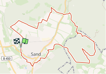
![](/images/other/stat-length.png)
![Tocht Te voet Bad Emstal - Habichtswaldsteig - Extratour Bad Emstal - Photo](https://media.geolcdn.com/t/1900/400/ext.pjpeg?maxdim=2&url=https%3A%2F%2Fstatic1.geolcdn.com%2Fsiteimages%2Fupload%2Ffiles%2F1545311037marcheuse_200dpi.jpg)
Habichtswaldsteig - Extratour Bad Emstal
SityTrail - itinéraires balisés pédestres
Tous les sentiers balisés d’Europe GUIDE+
![Lengte](/images/other/stat-length.png)
![Max. hoogte](https://static1.geolcdn.com/siteimages/upload/files/1508320355ic_sort_altitude_max_24dp.png)
![Positief hoogteverschil](https://static1.geolcdn.com/siteimages/upload/files/1508320355ic_sort_den_pos_24dp.png)
![Km-Effort](/images/other/stat-length.png)
![Min. hoogte](https://static1.geolcdn.com/siteimages/upload/files/1508320355ic_sort_altitude_min_24dp.png)
![Negatief hoogteverschil](https://static1.geolcdn.com/siteimages/upload/files/1508320355ic_sort_den_neg_24dp.png)
![Boucle](https://static1.geolcdn.com/siteimages/upload/files/16400158638029165_repeat_loop_refresh_sync_direction_icon.png)
![Te voet](https://static1.geolcdn.com/sitytour/trail-icons/100.png)
3h52
Moeilijkheid : Gemakkelijk
![Scan deze QR-code om de tocht te openen in de SityTrail-applicatie](https://capi.geolives.com/qq0zvz2zws4bq2lad0pu/sitytour/trails/3092369/qr.png?size=200)
Gratisgps-wandelapplicatie
Over ons
Tocht Te voet van 12,9 km beschikbaar op Hessen, Landkreis Kassel, Bad Emstal. Deze tocht wordt voorgesteld door SityTrail - itinéraires balisés pédestres.
Beschrijving
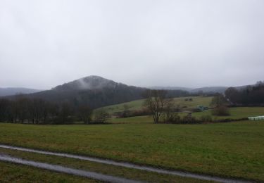
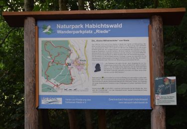
Es ist eine zauberhafte Tour durch satte Wiesentäler und tiefe Naturwälder, entlang an Waldrändern mit weiten Blicken über das Tal der Quellen und das ehemalige Land der Chatten.
Website: https://www.naturpark-habichtswald.de/touren/h6-im-tal-der-quellen
Plaatsbepaling
Opmerkingen
Wandeltochten in de omgeving
![Tocht Te voet Naumburg - Naumburg-Elbenberg - E3 - Photo](https://media.geolcdn.com/t/375/260/f46b84e6-0b0a-4b9f-bada-5d742549cd4f.jpeg&format=jpg&maxdim=2)
![Te voet Te voet](https://static1.geolcdn.com/sitytour/trail-icons/100.png)
Te voet
![](/images/other/stat-length.png)
![](https://static1.geolcdn.com/siteimages/upload/files/16400158638029165_repeat_loop_refresh_sync_direction_icon.png)
![Tocht Te voet Niedenstein - Niedenstein, N3 - Sengelsberg - Photo](https://media.geolcdn.com/t/375/260/4ed4a3a2-bd5e-4fad-8f78-44d080b6d336.jpeg&format=jpg&maxdim=2)
![Te voet Te voet](https://static1.geolcdn.com/sitytour/trail-icons/100.png)
Te voet
![](/images/other/stat-length.png)
![](https://static1.geolcdn.com/siteimages/upload/files/16400158638029165_repeat_loop_refresh_sync_direction_icon.png)
![Tocht Te voet Bad Emstal - Rundwanderweg](https://media.geolcdn.com/t/375/260/6152dd1e-c62a-41d9-ac07-c6e6a253257c.jpeg&format=jpg&maxdim=2)
![Te voet Te voet](https://static1.geolcdn.com/sitytour/trail-icons/100.png)
Te voet
![](/images/other/stat-length.png)
![](https://static1.geolcdn.com/siteimages/upload/files/16400158638029165_repeat_loop_refresh_sync_direction_icon.png)
![Tocht Te voet Bad Emstal - Naturparkweg 2 - Photo](https://media.geolcdn.com/t/375/260/56644780-7d07-49f2-8524-c7cbbaefe392.jpeg&format=jpg&maxdim=2)
![Te voet Te voet](https://static1.geolcdn.com/sitytour/trail-icons/100.png)
Te voet
![](/images/other/stat-length.png)
![](https://static1.geolcdn.com/siteimages/upload/files/16400158638029165_repeat_loop_refresh_sync_direction_icon.png)
![Tocht Te voet Schauenburg - Schauenburg, S4 - Photo](https://media.geolcdn.com/t/375/260/6a77dc7f-f009-4e54-bde5-58b683fb2794.jpeg&format=jpg&maxdim=2)
![Te voet Te voet](https://static1.geolcdn.com/sitytour/trail-icons/100.png)
Te voet
![](/images/other/stat-length.png)
![](https://static1.geolcdn.com/siteimages/upload/files/16400158638029165_repeat_loop_refresh_sync_direction_icon.png)
![Tocht Te voet Schauenburg - Schauenburg-Breitenbach, Rundweg 1 - Photo](https://media.geolcdn.com/t/375/260/032608dc-851a-4041-9641-fe96126ffeaa.jpeg&format=jpg&maxdim=2)
![Te voet Te voet](https://static1.geolcdn.com/sitytour/trail-icons/100.png)
Te voet
![](/images/other/stat-length.png)
![](https://static1.geolcdn.com/siteimages/upload/files/16400158638029165_repeat_loop_refresh_sync_direction_icon.png)
![Tocht Te voet Bad Emstal - Schauenburg, S1 - Photo](https://media.geolcdn.com/t/375/260/032608dc-851a-4041-9641-fe96126ffeaa.jpeg&format=jpg&maxdim=2)
![Te voet Te voet](https://static1.geolcdn.com/sitytour/trail-icons/100.png)
Te voet
![](/images/other/stat-length.png)
![](https://static1.geolcdn.com/siteimages/upload/files/16400158638029165_repeat_loop_refresh_sync_direction_icon.png)
![Tocht Te voet Schauenburg - Schauenburg, Rundweg 2 - Photo](https://media.geolcdn.com/t/375/260/6a77dc7f-f009-4e54-bde5-58b683fb2794.jpeg&format=jpg&maxdim=2)
![Te voet Te voet](https://static1.geolcdn.com/sitytour/trail-icons/100.png)
Te voet
![](/images/other/stat-length.png)
![](https://static1.geolcdn.com/siteimages/upload/files/16400158638029165_repeat_loop_refresh_sync_direction_icon.png)
![Tocht Te voet Niedenstein - Niedenstein, N5 - Rundweg zur Ruine Falkenstein - Photo](https://media.geolcdn.com/t/375/260/4ed4a3a2-bd5e-4fad-8f78-44d080b6d336.jpeg&format=jpg&maxdim=2)
![Te voet Te voet](https://static1.geolcdn.com/sitytour/trail-icons/100.png)
Te voet
![](/images/other/stat-length.png)
![](https://static1.geolcdn.com/siteimages/upload/files/16400158638029165_repeat_loop_refresh_sync_direction_icon.png)