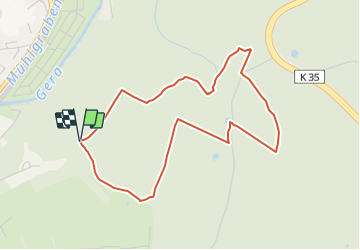
![](/images/other/stat-length.png)
![Tocht Te voet Unknown - Erfurter Steigerwald: Naturlehrpfad 2 - Photo](https://media.geolcdn.com/t/1900/400/4e9b298b-2c68-4c0c-a5ee-8973238fa0cb.jpeg&format=pjpeg&maxdim=2)
Erfurter Steigerwald: Naturlehrpfad 2
SityTrail - itinéraires balisés pédestres
Tous les sentiers balisés d’Europe GUIDE+
![Lengte](/images/other/stat-length.png)
![Max. hoogte](https://static1.geolcdn.com/siteimages/upload/files/1508320355ic_sort_altitude_max_24dp.png)
![Positief hoogteverschil](https://static1.geolcdn.com/siteimages/upload/files/1508320355ic_sort_den_pos_24dp.png)
![Km-Effort](/images/other/stat-length.png)
![Min. hoogte](https://static1.geolcdn.com/siteimages/upload/files/1508320355ic_sort_altitude_min_24dp.png)
![Negatief hoogteverschil](https://static1.geolcdn.com/siteimages/upload/files/1508320355ic_sort_den_neg_24dp.png)
![Boucle](https://static1.geolcdn.com/siteimages/upload/files/16400158638029165_repeat_loop_refresh_sync_direction_icon.png)
![Te voet](https://static1.geolcdn.com/sitytour/trail-icons/100.png)
1h07
Moeilijkheid : Gemakkelijk
![Scan deze QR-code om de tocht te openen in de SityTrail-applicatie](https://capi.geolives.com/qq0zvz2zws4bq2lad0pu/sitytour/trails/3091562/qr.png?size=200)
Gratisgps-wandelapplicatie
Over ons
Tocht Te voet van 4,1 km beschikbaar op Thüringen, Erfurt. Deze tocht wordt voorgesteld door SityTrail - itinéraires balisés pédestres.
Beschrijving
Beim Vorbild nur an wenigen Stellen markiert, dort mancherorts auch abweichend von den Darstellungen in vor Ort aufgestellten Karten. Daher Fehler im Wegverlauf möglich!
Symbol: rotes Eichhörnchen
Plaatsbepaling
Opmerkingen
Wandeltochten in de omgeving
![Tocht Te voet - Erfurter Steigerwald: Rotes Rad - Photo](https://media.geolcdn.com/t/375/260/b615b412-7687-43bb-8ee8-5f5191c0dd7b.jpeg&format=jpg&maxdim=2)
![Te voet Te voet](https://static1.geolcdn.com/sitytour/trail-icons/100.png)
Te voet
![](/images/other/stat-length.png)
![](https://static1.geolcdn.com/siteimages/upload/files/16400158638029165_repeat_loop_refresh_sync_direction_icon.png)
![Tocht Te voet - Erfurter Steigerwald: Gelbes Kreuz - Photo](https://media.geolcdn.com/t/375/260/5314cfb4-cb8d-45a6-a5e6-af89f728c013.jpeg&format=jpg&maxdim=2)
![Te voet Te voet](https://static1.geolcdn.com/sitytour/trail-icons/100.png)
Te voet
![](/images/other/stat-length.png)
![](https://static1.geolcdn.com/siteimages/upload/files/16400158638029165_repeat_loop_refresh_sync_direction_icon.png)
![Tocht Te voet - Wanderweg Luisenpark - Waldhaus Rhoda - Photo](https://media.geolcdn.com/t/375/260/5314cfb4-cb8d-45a6-a5e6-af89f728c013.jpeg&format=jpg&maxdim=2)
![Te voet Te voet](https://static1.geolcdn.com/sitytour/trail-icons/100.png)
Te voet
![](/images/other/stat-length.png)
![](https://static1.geolcdn.com/siteimages/upload/files/16400158638029165_repeat_loop_refresh_sync_direction_icon.png)
![Tocht Te voet - Erfurter Steigerwald: Grüner Balken - Photo](https://media.geolcdn.com/t/375/260/5314cfb4-cb8d-45a6-a5e6-af89f728c013.jpeg&format=jpg&maxdim=2)
![Te voet Te voet](https://static1.geolcdn.com/sitytour/trail-icons/100.png)
Te voet
![](/images/other/stat-length.png)
![](https://static1.geolcdn.com/siteimages/upload/files/16400158638029165_repeat_loop_refresh_sync_direction_icon.png)
![Tocht Te voet - Erfurter Steigerwald: Naturlehrpfad 1 - Photo](https://media.geolcdn.com/t/375/260/5314cfb4-cb8d-45a6-a5e6-af89f728c013.jpeg&format=jpg&maxdim=2)
![Te voet Te voet](https://static1.geolcdn.com/sitytour/trail-icons/100.png)
Te voet
![](/images/other/stat-length.png)
![](https://static1.geolcdn.com/siteimages/upload/files/16400158638029165_repeat_loop_refresh_sync_direction_icon.png)
![Tocht Te voet - Kleingartenwanderweg - Photo](https://media.geolcdn.com/t/375/260/9c383959-7aff-4e27-9bfd-ba8f113ed5e4.jpeg&format=jpg&maxdim=2)
![Te voet Te voet](https://static1.geolcdn.com/sitytour/trail-icons/100.png)
Te voet
![](/images/other/stat-length.png)
![](https://static1.geolcdn.com/siteimages/upload/files/16400158638029165_repeat_loop_refresh_sync_direction_icon.png)
![Tocht Te voet - Erfurter Steigerwald: Rundwanderweg 5,5 km - Photo](https://media.geolcdn.com/t/375/260/b615b412-7687-43bb-8ee8-5f5191c0dd7b.jpeg&format=jpg&maxdim=2)
![Te voet Te voet](https://static1.geolcdn.com/sitytour/trail-icons/100.png)
Te voet
![](/images/other/stat-length.png)
![](https://static1.geolcdn.com/siteimages/upload/files/16400158638029165_repeat_loop_refresh_sync_direction_icon.png)
![Tocht Te voet - Erfurter Steigerwald: Grüner Schrägstrich - Photo](https://media.geolcdn.com/t/375/260/ext.jpg?maxdim=2&url=https%3A%2F%2Fstatic1.geolcdn.com%2Fsiteimages%2Fupload%2Ffiles%2F1545311037marcheuse_200dpi.jpg)
![Te voet Te voet](https://static1.geolcdn.com/sitytour/trail-icons/100.png)
Te voet
![](/images/other/stat-length.png)
![](https://static1.geolcdn.com/siteimages/upload/files/16400158638029165_repeat_loop_refresh_sync_direction_icon.png)