![](/images/other/stat-length.png)
![Tocht Te voet Spiesen-Elversberg - Tannen-Rundwanderweg - Photo](https://media.geolcdn.com/t/1900/400/2be6ffdc-1ad3-4d8c-b098-19063d1242bb.jpeg&format=pjpeg&maxdim=2)
Tannen-Rundwanderweg
SityTrail - itinéraires balisés pédestres
Tous les sentiers balisés d’Europe GUIDE+
![Lengte](/images/other/stat-length.png)
Lengte
10,4 km
![Max. hoogte](https://static1.geolcdn.com/siteimages/upload/files/1508320355ic_sort_altitude_max_24dp.png)
Max. hoogte
314 m
![Positief hoogteverschil](https://static1.geolcdn.com/siteimages/upload/files/1508320355ic_sort_den_pos_24dp.png)
Positief hoogteverschil
176 m
![Km-Effort](/images/other/stat-length.png)
Km-Effort
12,7 km
![Min. hoogte](https://static1.geolcdn.com/siteimages/upload/files/1508320355ic_sort_altitude_min_24dp.png)
Min. hoogte
236 m
![Negatief hoogteverschil](https://static1.geolcdn.com/siteimages/upload/files/1508320355ic_sort_den_neg_24dp.png)
Negatief hoogteverschil
167 m
![Boucle](https://static1.geolcdn.com/siteimages/upload/files/16400158638029165_repeat_loop_refresh_sync_direction_icon.png)
Boucle
Neen
Markering
Datum van aanmaak :
2022-02-11 13:51:14.217
Laatste wijziging :
2022-02-11 13:51:14.217
![Te voet](https://static1.geolcdn.com/sitytour/trail-icons/100.png)
2h53
Moeilijkheid : Gemakkelijk
![Scan deze QR-code om de tocht te openen in de SityTrail-applicatie](https://capi.geolives.com/qq0zvz2zws4bq2lad0pu/sitytour/trails/3091390/qr.png?size=200)
Gratisgps-wandelapplicatie
Over ons
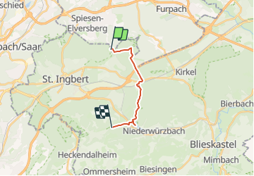
Tocht Te voet van 10,4 km beschikbaar op Saarland, Landkreis Neunkirchen, Spiesen-Elversberg. Deze tocht wordt voorgesteld door SityTrail - itinéraires balisés pédestres.
Beschrijving
Symbol: grüner Tannenbaum
Plaatsbepaling
Land:
Germany
Regio :
Saarland
Departement/Provincie :
Landkreis Neunkirchen
Gemeente :
Spiesen-Elversberg
Locatie:
Spiesen
Vertrek:(Dec)
Vertrek:(UTM)
366232 ; 5462179 (32U) N.
Opmerkingen
Wandeltochten in de omgeving
![Tocht Te voet Kirkel - DE-Ahorn - Photo](https://media.geolcdn.com/t/375/260/ce79857c-ba71-4dc2-b57a-e23652e6ffb4.jpeg&format=jpg&maxdim=2)
![Te voet Te voet](https://static1.geolcdn.com/sitytour/trail-icons/100.png)
DE-Ahorn
Te voet
Gemakkelijk
Kirkel,
Saarland,
Saarpfalz-Kreis,
Germany
![](/images/other/stat-length.png)
3,2 km | 3,7 km-effort
50min
![](https://static1.geolcdn.com/siteimages/upload/files/16400158638029165_repeat_loop_refresh_sync_direction_icon.png)
Neen
![Tocht Te voet Kirkel - Wildschwein-Rundwanderweg - Photo](https://media.geolcdn.com/t/375/260/90a7ee08-7bdb-4bfc-95ac-b4d770481c04.jpeg&format=jpg&maxdim=2)
![Te voet Te voet](https://static1.geolcdn.com/sitytour/trail-icons/100.png)
Wildschwein-Rundwanderweg
Te voet
Gemakkelijk
Kirkel,
Saarland,
Saarpfalz-Kreis,
Germany
![](/images/other/stat-length.png)
4,3 km | 5,3 km-effort
1h 11min
![](https://static1.geolcdn.com/siteimages/upload/files/16400158638029165_repeat_loop_refresh_sync_direction_icon.png)
Neen
![Tocht Te voet Sankt Ingbert - Hasen-Rundwanderweg Oberwürzbach - Photo](https://media.geolcdn.com/t/375/260/00567d36-9f17-43cb-8ff8-f2e5a3a18248.jpeg&format=jpg&maxdim=2)
![Te voet Te voet](https://static1.geolcdn.com/sitytour/trail-icons/100.png)
Hasen-Rundwanderweg Oberwürzbach
Te voet
Gemakkelijk
Sankt Ingbert,
Saarland,
Saarpfalz-Kreis,
Germany
![](/images/other/stat-length.png)
8,7 km | 12,8 km-effort
2h 54min
![](https://static1.geolcdn.com/siteimages/upload/files/16400158638029165_repeat_loop_refresh_sync_direction_icon.png)
Ja
![Tocht Te voet Sankt Ingbert - Reh-Rundwanderweg - Photo](https://media.geolcdn.com/t/375/260/65157b2e-b3ef-4ea5-9c6a-0f6b811c80c7.jpeg&format=jpg&maxdim=2)
![Te voet Te voet](https://static1.geolcdn.com/sitytour/trail-icons/100.png)
Reh-Rundwanderweg
Te voet
Gemakkelijk
Sankt Ingbert,
Saarland,
Saarpfalz-Kreis,
Germany
![](/images/other/stat-length.png)
9 km | 11 km-effort
2h 30min
![](https://static1.geolcdn.com/siteimages/upload/files/16400158638029165_repeat_loop_refresh_sync_direction_icon.png)
Ja
![Tocht Te voet Sulzbach/Saar - Karl-May-Weg (Sulzbacher Schleife) - Photo](https://media.geolcdn.com/t/375/260/83a6206a-05c6-4f58-8803-d77701894bd1.jpeg&format=jpg&maxdim=2)
![Te voet Te voet](https://static1.geolcdn.com/sitytour/trail-icons/100.png)
Karl-May-Weg (Sulzbacher Schleife)
Te voet
Gemakkelijk
Sulzbach/Saar,
Saarland,
Regionalverband Saarbrücken,
Germany
![](/images/other/stat-length.png)
13,4 km | 17,7 km-effort
4h 1min
![](https://static1.geolcdn.com/siteimages/upload/files/16400158638029165_repeat_loop_refresh_sync_direction_icon.png)
Ja
![Tocht Te voet Neunkirchen - Grenzsteinweg - Photo](https://media.geolcdn.com/t/375/260/ccd86a25-2a85-4745-8096-c096eae76907.jpeg&format=jpg&maxdim=2)
![Te voet Te voet](https://static1.geolcdn.com/sitytour/trail-icons/100.png)
Grenzsteinweg
Te voet
Gemakkelijk
Neunkirchen,
Saarland,
Landkreis Neunkirchen,
Germany
![](/images/other/stat-length.png)
5,5 km | 6,6 km-effort
1h 30min
![](https://static1.geolcdn.com/siteimages/upload/files/16400158638029165_repeat_loop_refresh_sync_direction_icon.png)
Neen
![Tocht Te voet Neunkirchen - Maltitzweg - Photo](https://media.geolcdn.com/t/375/260/a3e9f808-8522-447e-a37e-0a55d15b9d0b.jpeg&format=jpg&maxdim=2)
![Te voet Te voet](https://static1.geolcdn.com/sitytour/trail-icons/100.png)
Maltitzweg
Te voet
Gemakkelijk
Neunkirchen,
Saarland,
Landkreis Neunkirchen,
Germany
![](/images/other/stat-length.png)
10 km | 12,3 km-effort
2h 47min
![](https://static1.geolcdn.com/siteimages/upload/files/16400158638029165_repeat_loop_refresh_sync_direction_icon.png)
Ja
![Tocht Te voet Neunkirchen - 12-Weiher-Weg - Photo](https://media.geolcdn.com/t/375/260/cc7ef2e5-4fa6-4bc5-99b4-38db629b1460.jpeg&format=jpg&maxdim=2)
![Te voet Te voet](https://static1.geolcdn.com/sitytour/trail-icons/100.png)
12-Weiher-Weg
Te voet
Gemakkelijk
Neunkirchen,
Saarland,
Landkreis Neunkirchen,
Germany
![](/images/other/stat-length.png)
10,2 km | 12,9 km-effort
2h 55min
![](https://static1.geolcdn.com/siteimages/upload/files/16400158638029165_repeat_loop_refresh_sync_direction_icon.png)
Ja
![Tocht Te voet Neunkirchen - Biergartenweg - Photo](https://media.geolcdn.com/t/375/260/a3e9f808-8522-447e-a37e-0a55d15b9d0b.jpeg&format=jpg&maxdim=2)
![Te voet Te voet](https://static1.geolcdn.com/sitytour/trail-icons/100.png)
Biergartenweg
Te voet
Medium
Neunkirchen,
Saarland,
Landkreis Neunkirchen,
Germany
![](/images/other/stat-length.png)
16,4 km | 21 km-effort
4h 44min
![](https://static1.geolcdn.com/siteimages/upload/files/16400158638029165_repeat_loop_refresh_sync_direction_icon.png)
Ja