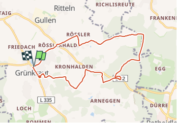
![](/images/other/stat-length.png)
![Tocht Te voet Grünkraut - Rundwanderweg 2 Gemeinde Grünkraut - Photo](https://media.geolcdn.com/t/1900/400/199c5d3a-ed67-4f83-8095-4c30c8deb8f5.jpeg&format=pjpeg&maxdim=2)
Rundwanderweg 2 Gemeinde Grünkraut
SityTrail - itinéraires balisés pédestres
Tous les sentiers balisés d’Europe GUIDE+
![Lengte](/images/other/stat-length.png)
![Max. hoogte](https://static1.geolcdn.com/siteimages/upload/files/1508320355ic_sort_altitude_max_24dp.png)
![Positief hoogteverschil](https://static1.geolcdn.com/siteimages/upload/files/1508320355ic_sort_den_pos_24dp.png)
![Km-Effort](/images/other/stat-length.png)
![Min. hoogte](https://static1.geolcdn.com/siteimages/upload/files/1508320355ic_sort_altitude_min_24dp.png)
![Negatief hoogteverschil](https://static1.geolcdn.com/siteimages/upload/files/1508320355ic_sort_den_neg_24dp.png)
![Boucle](https://static1.geolcdn.com/siteimages/upload/files/16400158638029165_repeat_loop_refresh_sync_direction_icon.png)
![Te voet](https://static1.geolcdn.com/sitytour/trail-icons/100.png)
2h28
Moeilijkheid : Gemakkelijk
![Scan deze QR-code om de tocht te openen in de SityTrail-applicatie](https://capi.geolives.com/qq0zvz2zws4bq2lad0pu/sitytour/trails/3091193/qr.png?size=200)
Gratisgps-wandelapplicatie
Over ons
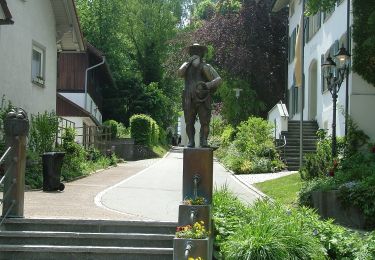
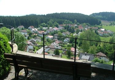
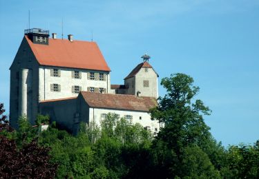
Tocht Te voet van 8,8 km beschikbaar op Baden-Württemberg, Landkreis Ravensburg, Grünkraut. Deze tocht wordt voorgesteld door SityTrail - itinéraires balisés pédestres.
Beschrijving
Trail created by Gemeinde Grünkraut.
Symbol: Ziffer 2, oben und unten gerundeter Pfeil mit Schrift Rundwanderweg Grünkraut und Rundpfeil in weiß auf braunem Grund
Plaatsbepaling
Opmerkingen
Wandeltochten in de omgeving
![Tocht Te voet Grünkraut - Rundwanderweg 1 Ortsrunde Gemeinde Grünkraut - Photo](https://media.geolcdn.com/t/375/260/199c5d3a-ed67-4f83-8095-4c30c8deb8f5.jpeg&format=jpg&maxdim=2)
![Te voet Te voet](https://static1.geolcdn.com/sitytour/trail-icons/100.png)
Te voet
![](/images/other/stat-length.png)
![](https://static1.geolcdn.com/siteimages/upload/files/16400158638029165_repeat_loop_refresh_sync_direction_icon.png)
![Tocht Te voet Bodnegg - Rundwanderweg 3 der Gemeinde Bodnegg - Photo](https://media.geolcdn.com/t/375/260/6322cb85-9120-4fb5-b2ea-3e9156101e2a.jpeg&format=jpg&maxdim=2)
![Te voet Te voet](https://static1.geolcdn.com/sitytour/trail-icons/100.png)
Te voet
![](/images/other/stat-length.png)
![](https://static1.geolcdn.com/siteimages/upload/files/16400158638029165_repeat_loop_refresh_sync_direction_icon.png)
![Tocht Te voet Bodnegg - Rundwanderweg 1 der Gemeinde Bodnegg - Photo](https://media.geolcdn.com/t/375/260/4bd5687c-aa18-424b-b766-107cbddd7980.jpeg&format=jpg&maxdim=2)
![Te voet Te voet](https://static1.geolcdn.com/sitytour/trail-icons/100.png)
Te voet
![](/images/other/stat-length.png)
![](https://static1.geolcdn.com/siteimages/upload/files/16400158638029165_repeat_loop_refresh_sync_direction_icon.png)
![Tocht Te voet Grünkraut - Rundwanderweg 5 Gemeinde Grünkraut - Photo](https://media.geolcdn.com/t/375/260/199c5d3a-ed67-4f83-8095-4c30c8deb8f5.jpeg&format=jpg&maxdim=2)
![Te voet Te voet](https://static1.geolcdn.com/sitytour/trail-icons/100.png)
Te voet
![](/images/other/stat-length.png)
![](https://static1.geolcdn.com/siteimages/upload/files/16400158638029165_repeat_loop_refresh_sync_direction_icon.png)
![Tocht Te voet Bodnegg - Rundwanderweg 2 der Gemeinde Bodnegg - Photo](https://media.geolcdn.com/t/375/260/d3d216a8-2119-46fe-9bbf-81601b547ee1.jpeg&format=jpg&maxdim=2)
![Te voet Te voet](https://static1.geolcdn.com/sitytour/trail-icons/100.png)
Te voet
![](/images/other/stat-length.png)
![](https://static1.geolcdn.com/siteimages/upload/files/16400158638029165_repeat_loop_refresh_sync_direction_icon.png)
![Tocht Te voet Waldburg - Wanderweg 7 der Gemeinde Waldburg - Photo](https://media.geolcdn.com/t/375/260/114ad953-f94e-47b2-be64-c83ffcb89c3a.jpeg&format=jpg&maxdim=2)
![Te voet Te voet](https://static1.geolcdn.com/sitytour/trail-icons/100.png)
Te voet
![](/images/other/stat-length.png)
![](https://static1.geolcdn.com/siteimages/upload/files/16400158638029165_repeat_loop_refresh_sync_direction_icon.png)
![Tocht Te voet Grünkraut - Rundwanderweg 7 Gemeinde Grünkraut - Photo](https://media.geolcdn.com/t/375/260/199c5d3a-ed67-4f83-8095-4c30c8deb8f5.jpeg&format=jpg&maxdim=2)
![Te voet Te voet](https://static1.geolcdn.com/sitytour/trail-icons/100.png)
Te voet
![](/images/other/stat-length.png)
![](https://static1.geolcdn.com/siteimages/upload/files/16400158638029165_repeat_loop_refresh_sync_direction_icon.png)