![](/images/other/stat-length.png)
![Tocht Te voet Lichtenau - Altenau-Wanderweg - Photo](https://media.geolcdn.com/t/1900/400/13706d52-5b12-4092-9d1e-a0e2c463e76c.jpeg&format=pjpeg&maxdim=2)
Altenau-Wanderweg
SityTrail - itinéraires balisés pédestres
Tous les sentiers balisés d’Europe GUIDE+
![Lengte](/images/other/stat-length.png)
![Max. hoogte](https://static1.geolcdn.com/siteimages/upload/files/1508320355ic_sort_altitude_max_24dp.png)
![Positief hoogteverschil](https://static1.geolcdn.com/siteimages/upload/files/1508320355ic_sort_den_pos_24dp.png)
![Km-Effort](/images/other/stat-length.png)
![Min. hoogte](https://static1.geolcdn.com/siteimages/upload/files/1508320355ic_sort_altitude_min_24dp.png)
![Negatief hoogteverschil](https://static1.geolcdn.com/siteimages/upload/files/1508320355ic_sort_den_neg_24dp.png)
![Boucle](https://static1.geolcdn.com/siteimages/upload/files/16400158638029165_repeat_loop_refresh_sync_direction_icon.png)
![Te voet](https://static1.geolcdn.com/sitytour/trail-icons/100.png)
4h21
Moeilijkheid : Gemakkelijk
![Scan deze QR-code om de tocht te openen in de SityTrail-applicatie](https://capi.geolives.com/qq0zvz2zws4bq2lad0pu/sitytour/trails/3090881/qr.png?size=200)
Gratisgps-wandelapplicatie
Over ons
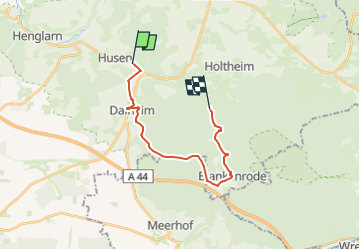
Tocht Te voet van 15,1 km beschikbaar op Noordrijn-Westfalen, Kreis Paderborn, Lichtenau. Deze tocht wordt voorgesteld door SityTrail - itinéraires balisés pédestres.
Beschrijving
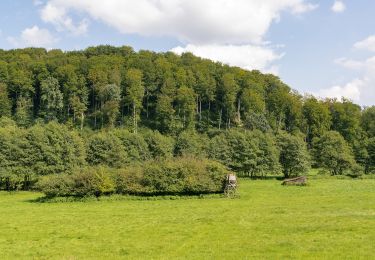
Es gibt einen älteren Altenau-Rundwanderweg, mit einem weißen A in weißem Kreis als Markierung und den neuen Altenau-Wanderweg, mit einem grün-bunten Logo. Diese sollten nicht verwechselt werden.
Plaatsbepaling
Opmerkingen
Wandeltochten in de omgeving
![Tocht Te voet Lichtenau - A6 (Dalheim) - Photo](https://media.geolcdn.com/t/375/260/3da96db5-1e47-47c9-b27b-86004a3e1ccf.jpeg&format=jpg&maxdim=2)
![Te voet Te voet](https://static1.geolcdn.com/sitytour/trail-icons/100.png)
Te voet
![](/images/other/stat-length.png)
![](https://static1.geolcdn.com/siteimages/upload/files/16400158638029165_repeat_loop_refresh_sync_direction_icon.png)
![Tocht Te voet Lichtenau - A3 (Dalheim) - Photo](https://media.geolcdn.com/t/375/260/1586ca5c-7721-4ac7-bed4-fb1f7880cd59.jpeg&format=jpg&maxdim=2)
![Te voet Te voet](https://static1.geolcdn.com/sitytour/trail-icons/100.png)
Te voet
![](/images/other/stat-length.png)
![](https://static1.geolcdn.com/siteimages/upload/files/16400158638029165_repeat_loop_refresh_sync_direction_icon.png)
![Tocht Te voet Lichtenau - A5 (Dalheim) - Photo](https://media.geolcdn.com/t/375/260/1586ca5c-7721-4ac7-bed4-fb1f7880cd59.jpeg&format=jpg&maxdim=2)
![Te voet Te voet](https://static1.geolcdn.com/sitytour/trail-icons/100.png)
Te voet
![](/images/other/stat-length.png)
![](https://static1.geolcdn.com/siteimages/upload/files/16400158638029165_repeat_loop_refresh_sync_direction_icon.png)
![Tocht Te voet Lichtenau - A2 (Dalheim) - Photo](https://media.geolcdn.com/t/375/260/1586ca5c-7721-4ac7-bed4-fb1f7880cd59.jpeg&format=jpg&maxdim=2)
![Te voet Te voet](https://static1.geolcdn.com/sitytour/trail-icons/100.png)
Te voet
![](/images/other/stat-length.png)
![](https://static1.geolcdn.com/siteimages/upload/files/16400158638029165_repeat_loop_refresh_sync_direction_icon.png)
![Tocht Te voet Lichtenau - A1 (Dalheim) - Photo](https://media.geolcdn.com/t/375/260/3da96db5-1e47-47c9-b27b-86004a3e1ccf.jpeg&format=jpg&maxdim=2)
![Te voet Te voet](https://static1.geolcdn.com/sitytour/trail-icons/100.png)
Te voet
![](/images/other/stat-length.png)
![](https://static1.geolcdn.com/siteimages/upload/files/16400158638029165_repeat_loop_refresh_sync_direction_icon.png)
![Tocht Te voet Lichtenau - Sirexen Rundweg A9 - Photo](https://media.geolcdn.com/t/375/260/2a2bc2fc-fec9-4e1c-98f7-68020393c66e.jpeg&format=jpg&maxdim=2)
![Te voet Te voet](https://static1.geolcdn.com/sitytour/trail-icons/100.png)
Te voet
![](/images/other/stat-length.png)
![](https://static1.geolcdn.com/siteimages/upload/files/16400158638029165_repeat_loop_refresh_sync_direction_icon.png)
![Tocht Te voet Lichtenau - Holtheim Rundweg A3 - Photo](https://media.geolcdn.com/t/375/260/c3838117-d3bb-4f04-a0bc-2735ba38b6fe.jpeg&format=jpg&maxdim=2)
![Te voet Te voet](https://static1.geolcdn.com/sitytour/trail-icons/100.png)
Te voet
![](/images/other/stat-length.png)
![](https://static1.geolcdn.com/siteimages/upload/files/16400158638029165_repeat_loop_refresh_sync_direction_icon.png)
![Tocht Te voet Lichtenau - Blankenrode Rundweg A6 - Photo](https://media.geolcdn.com/t/375/260/ext.jpg?maxdim=2&url=https%3A%2F%2Fstatic1.geolcdn.com%2Fsiteimages%2Fupload%2Ffiles%2F1545311037marcheuse_200dpi.jpg)
![Te voet Te voet](https://static1.geolcdn.com/sitytour/trail-icons/100.png)
Te voet
![](/images/other/stat-length.png)
![](https://static1.geolcdn.com/siteimages/upload/files/16400158638029165_repeat_loop_refresh_sync_direction_icon.png)