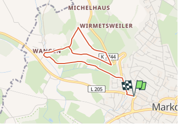
![](/images/other/stat-length.png)
![Tocht Te voet Markdorf - Wanderwege Markdorf: Vogelweg - Photo](https://media.geolcdn.com/t/1900/400/b1e5e460-44e8-4932-8fe3-58c7e2b4f663.jpeg&format=pjpeg&maxdim=2)
Wanderwege Markdorf: Vogelweg
SityTrail - itinéraires balisés pédestres
Tous les sentiers balisés d’Europe GUIDE+
![Lengte](/images/other/stat-length.png)
![Max. hoogte](https://static1.geolcdn.com/siteimages/upload/files/1508320355ic_sort_altitude_max_24dp.png)
![Positief hoogteverschil](https://static1.geolcdn.com/siteimages/upload/files/1508320355ic_sort_den_pos_24dp.png)
![Km-Effort](/images/other/stat-length.png)
![Min. hoogte](https://static1.geolcdn.com/siteimages/upload/files/1508320355ic_sort_altitude_min_24dp.png)
![Negatief hoogteverschil](https://static1.geolcdn.com/siteimages/upload/files/1508320355ic_sort_den_neg_24dp.png)
![Boucle](https://static1.geolcdn.com/siteimages/upload/files/16400158638029165_repeat_loop_refresh_sync_direction_icon.png)
![Te voet](https://static1.geolcdn.com/sitytour/trail-icons/100.png)
1h26
Moeilijkheid : Gemakkelijk
![Scan deze QR-code om de tocht te openen in de SityTrail-applicatie](https://capi.geolives.com/qq0zvz2zws4bq2lad0pu/sitytour/trails/3090788/qr.png?size=200)
Gratisgps-wandelapplicatie
Over ons
Tocht Te voet van 5,2 km beschikbaar op Baden-Württemberg, Bodenseekreis, Markdorf. Deze tocht wordt voorgesteld door SityTrail - itinéraires balisés pédestres.
Beschrijving
Trail created by Tourismusgemeinschaft Gehrenberg-Bodensee.
Symbol: schwarzer Vogel mit ausgebreiteten Flügeln auf weißem Grund
Website: https://www.gehrenberg-bodensee.de/
Plaatsbepaling
Opmerkingen
Wandeltochten in de omgeving
![Tocht Te voet Friedrichshafen - Planetenweg Kluftern - Photo](https://media.geolcdn.com/t/375/260/46733009-a77d-469a-8bf1-fb80e19f2d17.jpeg&format=jpg&maxdim=2)
![Te voet Te voet](https://static1.geolcdn.com/sitytour/trail-icons/100.png)
Te voet
![](/images/other/stat-length.png)
![](https://static1.geolcdn.com/siteimages/upload/files/16400158638029165_repeat_loop_refresh_sync_direction_icon.png)
![Tocht Te voet Bermatingen - Rundweg B5 - Photo](https://media.geolcdn.com/t/375/260/5fa6ab2f-fb20-4449-9ac8-ef50196935f6.jpeg&format=jpg&maxdim=2)
![Te voet Te voet](https://static1.geolcdn.com/sitytour/trail-icons/100.png)
Te voet
![](/images/other/stat-length.png)
![](https://static1.geolcdn.com/siteimages/upload/files/16400158638029165_repeat_loop_refresh_sync_direction_icon.png)
![Tocht Te voet Bermatingen - Rundweg B4 - Photo](https://media.geolcdn.com/t/375/260/ab7b3cca-1476-48a6-afce-358eba7428e2.jpeg&format=jpg&maxdim=2)
![Te voet Te voet](https://static1.geolcdn.com/sitytour/trail-icons/100.png)
Te voet
![](/images/other/stat-length.png)
![](https://static1.geolcdn.com/siteimages/upload/files/16400158638029165_repeat_loop_refresh_sync_direction_icon.png)
![Tocht Te voet Bermatingen - Rundweg B3 - Photo](https://media.geolcdn.com/t/375/260/ba1a7fea-e706-4424-b12c-59b17b649f8e.jpeg&format=jpg&maxdim=2)
![Te voet Te voet](https://static1.geolcdn.com/sitytour/trail-icons/100.png)
Te voet
![](/images/other/stat-length.png)
![](https://static1.geolcdn.com/siteimages/upload/files/16400158638029165_repeat_loop_refresh_sync_direction_icon.png)
![Tocht Te voet Bermatingen - Rundweg A1 - Photo](https://media.geolcdn.com/t/375/260/63b741f5-a6e3-4fe4-893a-bff6ecd72008.jpeg&format=jpg&maxdim=2)
![Te voet Te voet](https://static1.geolcdn.com/sitytour/trail-icons/100.png)
Te voet
![](/images/other/stat-length.png)
![](https://static1.geolcdn.com/siteimages/upload/files/16400158638029165_repeat_loop_refresh_sync_direction_icon.png)
![Tocht Te voet Bermatingen - Rundweg A2 - Photo](https://media.geolcdn.com/t/375/260/8a0d5958-3e75-4846-b1d2-fd2cae4fa568.jpeg&format=jpg&maxdim=2)
![Te voet Te voet](https://static1.geolcdn.com/sitytour/trail-icons/100.png)
Te voet
![](/images/other/stat-length.png)
![](https://static1.geolcdn.com/siteimages/upload/files/16400158638029165_repeat_loop_refresh_sync_direction_icon.png)
![Tocht Te voet Bermatingen - Rundweg B2 - Photo](https://media.geolcdn.com/t/375/260/cd072049-360e-431c-bd2c-80671c66591d.jpeg&format=jpg&maxdim=2)
![Te voet Te voet](https://static1.geolcdn.com/sitytour/trail-icons/100.png)
Te voet
![](/images/other/stat-length.png)
![](https://static1.geolcdn.com/siteimages/upload/files/16400158638029165_repeat_loop_refresh_sync_direction_icon.png)
![Tocht Te voet Bermatingen - Rundweg B1 - Photo](https://media.geolcdn.com/t/375/260/cd072049-360e-431c-bd2c-80671c66591d.jpeg&format=jpg&maxdim=2)
![Te voet Te voet](https://static1.geolcdn.com/sitytour/trail-icons/100.png)
Te voet
![](/images/other/stat-length.png)
![](https://static1.geolcdn.com/siteimages/upload/files/16400158638029165_repeat_loop_refresh_sync_direction_icon.png)
![Tocht Te voet Bermatingen - Rundweg B6 - Photo](https://media.geolcdn.com/t/375/260/ae4c1c91-559e-4646-8685-f780ec046570.jpeg&format=jpg&maxdim=2)
![Te voet Te voet](https://static1.geolcdn.com/sitytour/trail-icons/100.png)
Te voet
![](/images/other/stat-length.png)
![](https://static1.geolcdn.com/siteimages/upload/files/16400158638029165_repeat_loop_refresh_sync_direction_icon.png)