![](/images/other/stat-length.png)
![Tocht Te voet Obernhof - Vier-Täler-Tour - Photo](https://media.geolcdn.com/t/1900/400/1062c10a-15c8-4924-a2ee-6396706e86c8.jpeg&format=pjpeg&maxdim=2)
Vier-Täler-Tour
SityTrail - itinéraires balisés pédestres
Tous les sentiers balisés d’Europe GUIDE+
![Lengte](/images/other/stat-length.png)
Lengte
18,2 km
![Max. hoogte](https://static1.geolcdn.com/siteimages/upload/files/1508320355ic_sort_altitude_max_24dp.png)
Max. hoogte
305 m
![Positief hoogteverschil](https://static1.geolcdn.com/siteimages/upload/files/1508320355ic_sort_den_pos_24dp.png)
Positief hoogteverschil
429 m
![Km-Effort](/images/other/stat-length.png)
Km-Effort
24 km
![Min. hoogte](https://static1.geolcdn.com/siteimages/upload/files/1508320355ic_sort_altitude_min_24dp.png)
Min. hoogte
82 m
![Negatief hoogteverschil](https://static1.geolcdn.com/siteimages/upload/files/1508320355ic_sort_den_neg_24dp.png)
Negatief hoogteverschil
435 m
![Boucle](https://static1.geolcdn.com/siteimages/upload/files/16400158638029165_repeat_loop_refresh_sync_direction_icon.png)
Boucle
Neen
Markering
Datum van aanmaak :
2022-02-11 13:34:10.178
Laatste wijziging :
2022-02-11 13:34:10.178
![Te voet](https://static1.geolcdn.com/sitytour/trail-icons/100.png)
5h26
Moeilijkheid : Medium
![Scan deze QR-code om de tocht te openen in de SityTrail-applicatie](https://capi.geolives.com/qq0zvz2zws4bq2lad0pu/sitytour/trails/3090574/qr.png?size=200)
Gratisgps-wandelapplicatie
Over ons
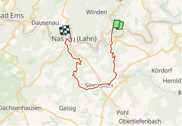
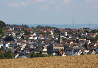
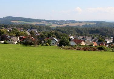
Tocht Te voet van 18,2 km beschikbaar op Rijnland-Palts, Rhein-Lahn-Kreis, Obernhof. Deze tocht wordt voorgesteld door SityTrail - itinéraires balisés pédestres.
Beschrijving
Trail created by Tourist-Information Nassauer Land e.V..
Symbol: Gelbes Metallschild mit blauem Text "Vier-Täler-Tour"
Plaatsbepaling
Land:
Germany
Regio :
Rijnland-Palts
Departement/Provincie :
Rhein-Lahn-Kreis
Gemeente :
Obernhof
Locatie:
Unknown
Vertrek:(Dec)
Vertrek:(UTM)
418220 ; 5574498 (32U) N.
Opmerkingen
Wandeltochten in de omgeving
![Tocht Te voet Gackenbach - Wäller Tour Buchfinkenland - Photo](https://media.geolcdn.com/t/375/260/ab9dec02-ee60-4578-b94d-e196a509639c.jpeg&format=jpg&maxdim=2)
![Te voet Te voet](https://static1.geolcdn.com/sitytour/trail-icons/100.png)
Wäller Tour Buchfinkenland
Te voet
Gemakkelijk
Gackenbach,
Rijnland-Palts,
Westerwaldkreis,
Germany
![](/images/other/stat-length.png)
14,3 km | 19,5 km-effort
4h 25min
![](https://static1.geolcdn.com/siteimages/upload/files/16400158638029165_repeat_loop_refresh_sync_direction_icon.png)
Ja
![Tocht Te voet Obernhof - Gelbachhöhen-Tour - Photo](https://media.geolcdn.com/t/375/260/6c8be9c2-44c7-4314-b336-6552d9905e3c.jpeg&format=jpg&maxdim=2)
![Te voet Te voet](https://static1.geolcdn.com/sitytour/trail-icons/100.png)
Gelbachhöhen-Tour
Te voet
Gemakkelijk
Obernhof,
Rijnland-Palts,
Rhein-Lahn-Kreis,
Germany
![](/images/other/stat-length.png)
11,8 km | 17,1 km-effort
3h 52min
![](https://static1.geolcdn.com/siteimages/upload/files/16400158638029165_repeat_loop_refresh_sync_direction_icon.png)
Ja
![Tocht Te voet Laurenburg - Burgweg - Photo](https://media.geolcdn.com/t/375/260/ef1c1921-1c75-43e6-955e-47c76abfcdcb.jpeg&format=jpg&maxdim=2)
![Te voet Te voet](https://static1.geolcdn.com/sitytour/trail-icons/100.png)
Burgweg
Te voet
Gemakkelijk
Laurenburg,
Rijnland-Palts,
Rhein-Lahn-Kreis,
Germany
![](/images/other/stat-length.png)
4 km | 5,6 km-effort
1h 16min
![](https://static1.geolcdn.com/siteimages/upload/files/16400158638029165_repeat_loop_refresh_sync_direction_icon.png)
Neen
![Tocht Te voet Seelbach - Klosterweg - Photo](https://media.geolcdn.com/t/375/260/e252bca3-2555-46c9-b515-f8887917da9f.jpeg&format=jpg&maxdim=2)
![Te voet Te voet](https://static1.geolcdn.com/sitytour/trail-icons/100.png)
Klosterweg
Te voet
Gemakkelijk
Seelbach,
Rijnland-Palts,
Rhein-Lahn-Kreis,
Germany
![](/images/other/stat-length.png)
14,9 km | 19,5 km-effort
4h 26min
![](https://static1.geolcdn.com/siteimages/upload/files/16400158638029165_repeat_loop_refresh_sync_direction_icon.png)
Ja
![Tocht Te voet Hübingen - Buchfinkenland kleiner Rundwanderweg B3 - Photo](https://media.geolcdn.com/t/375/260/083c03f9-c242-4742-bf4e-671c480b2074.jpeg&format=jpg&maxdim=2)
![Te voet Te voet](https://static1.geolcdn.com/sitytour/trail-icons/100.png)
Buchfinkenland kleiner Rundwanderweg B3
Te voet
Gemakkelijk
Hübingen,
Rijnland-Palts,
Westerwaldkreis,
Germany
![](/images/other/stat-length.png)
7,5 km | 10,2 km-effort
2h 19min
![](https://static1.geolcdn.com/siteimages/upload/files/16400158638029165_repeat_loop_refresh_sync_direction_icon.png)
Ja
![Tocht Te voet Hübingen - Buchfinkenland großer Rundwanderweg B1 - Photo](https://media.geolcdn.com/t/375/260/ab9dec02-ee60-4578-b94d-e196a509639c.jpeg&format=jpg&maxdim=2)
![Te voet Te voet](https://static1.geolcdn.com/sitytour/trail-icons/100.png)
Buchfinkenland großer Rundwanderweg B1
Te voet
Gemakkelijk
Hübingen,
Rijnland-Palts,
Westerwaldkreis,
Germany
![](/images/other/stat-length.png)
14,4 km | 19,5 km-effort
4h 26min
![](https://static1.geolcdn.com/siteimages/upload/files/16400158638029165_repeat_loop_refresh_sync_direction_icon.png)
Neen
![Tocht Te voet Attenhausen - Dörsbach Mühlenwanderweg - Photo](https://media.geolcdn.com/t/375/260/ext.jpg?maxdim=2&url=https%3A%2F%2Fstatic1.geolcdn.com%2Fsiteimages%2Fupload%2Ffiles%2F1545311037marcheuse_200dpi.jpg)
![Te voet Te voet](https://static1.geolcdn.com/sitytour/trail-icons/100.png)
Dörsbach Mühlenwanderweg
Te voet
Gemakkelijk
Attenhausen,
Rijnland-Palts,
Rhein-Lahn-Kreis,
Germany
![](/images/other/stat-length.png)
7,3 km | 9,5 km-effort
2h 10min
![](https://static1.geolcdn.com/siteimages/upload/files/16400158638029165_repeat_loop_refresh_sync_direction_icon.png)
Neen
![Tocht Fiets Obernhof - Duitsland - Lahntal - Photo](https://media.geolcdn.com/t/375/260/ext.jpg?maxdim=2&url=https%3A%2F%2Fstatic1.geolcdn.com%2Fsiteimages%2Fupload%2Ffiles%2F1524743154velo.jpg)
![Fiets Fiets](https://static1.geolcdn.com/sitytour/trail-icons/200.png)
Duitsland - Lahntal
Fiets
Heel gemakkelijk
Obernhof,
Rijnland-Palts,
Rhein-Lahn-Kreis,
Germany
![](/images/other/stat-length.png)
186 km | 235 km-effort
Onbekend
![](https://static1.geolcdn.com/siteimages/upload/files/16400158638029165_repeat_loop_refresh_sync_direction_icon.png)
Neen