![](/images/other/stat-length.png)
![Tocht Te voet Waldmünchen - Wm5 »Böhmerwaldweg« (Waldmünchen) - Photo](https://media.geolcdn.com/t/1900/400/925a1e31-e6f2-4614-9e6b-da996f61c722.jpeg&format=pjpeg&maxdim=2)
Wm5 »Böhmerwaldweg« (Waldmünchen)
SityTrail - itinéraires balisés pédestres
Tous les sentiers balisés d’Europe GUIDE+
![Lengte](/images/other/stat-length.png)
Lengte
11,3 km
![Max. hoogte](https://static1.geolcdn.com/siteimages/upload/files/1508320355ic_sort_altitude_max_24dp.png)
Max. hoogte
899 m
![Positief hoogteverschil](https://static1.geolcdn.com/siteimages/upload/files/1508320355ic_sort_den_pos_24dp.png)
Positief hoogteverschil
262 m
![Km-Effort](/images/other/stat-length.png)
Km-Effort
15,3 km
![Min. hoogte](https://static1.geolcdn.com/siteimages/upload/files/1508320355ic_sort_altitude_min_24dp.png)
Min. hoogte
593 m
![Negatief hoogteverschil](https://static1.geolcdn.com/siteimages/upload/files/1508320355ic_sort_den_neg_24dp.png)
Negatief hoogteverschil
425 m
![Boucle](https://static1.geolcdn.com/siteimages/upload/files/16400158638029165_repeat_loop_refresh_sync_direction_icon.png)
Boucle
Neen
Markering
Datum van aanmaak :
2022-02-11 13:18:16.976
Laatste wijziging :
2022-02-11 13:18:16.976
![Te voet](https://static1.geolcdn.com/sitytour/trail-icons/100.png)
3h28
Moeilijkheid : Gemakkelijk
![Scan deze QR-code om de tocht te openen in de SityTrail-applicatie](https://capi.geolives.com/qq0zvz2zws4bq2lad0pu/sitytour/trails/3089907/qr.png?size=200)
Gratisgps-wandelapplicatie
Over ons
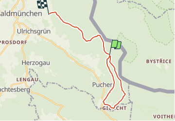
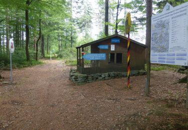
Tocht Te voet van 11,3 km beschikbaar op Beieren, Landkreis Cham, Waldmünchen. Deze tocht wordt voorgesteld door SityTrail - itinéraires balisés pédestres.
Beschrijving
Trail created by ARGE Further Wanderwege.
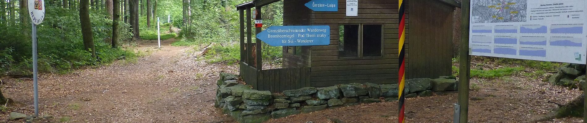
Symbol: Schwarze Wegnummer im weißen Bereich des oben weißen / unten roten, rechteckigen Hintergrunds
Plaatsbepaling
Land:
Germany
Regio :
Beieren
Departement/Provincie :
Landkreis Cham
Gemeente :
Waldmünchen
Locatie:
Unknown
Vertrek:(Dec)
Vertrek:(UTM)
338157 ; 5469634 (33U) N.
Opmerkingen
Wandeltochten in de omgeving
![Tocht Te voet Česká Kubice - W9 Waldmünchen - Lehmgrubenweg (D/CZ) (- Čerchov/Schwarzkopf) - Photo](https://media.geolcdn.com/t/375/260/e6a470f2-4e83-4477-978d-075caaeee660.jpeg&format=jpg&maxdim=2)
![Te voet Te voet](https://static1.geolcdn.com/sitytour/trail-icons/100.png)
W9 Waldmünchen - Lehmgrubenweg (D/CZ) (- Čerchov/Schwarzkopf)
Te voet
Gemakkelijk
Česká Kubice,
Zuidwest,
Regio Pilsen,
Czech Republic
![](/images/other/stat-length.png)
3,8 km | 4,9 km-effort
1h 6min
![](https://static1.geolcdn.com/siteimages/upload/files/16400158638029165_repeat_loop_refresh_sync_direction_icon.png)
Neen
![Tocht Te voet Chodov - CZ-3672 - Photo](https://media.geolcdn.com/t/375/260/e9841dd7-c49b-4629-a271-2d9c5432926f.jpeg&format=jpg&maxdim=2)
![Te voet Te voet](https://static1.geolcdn.com/sitytour/trail-icons/100.png)
CZ-3672
Te voet
Medium
Chodov,
Zuidwest,
Regio Pilsen,
Czech Republic
![](/images/other/stat-length.png)
14,8 km | 22 km-effort
4h 57min
![](https://static1.geolcdn.com/siteimages/upload/files/16400158638029165_repeat_loop_refresh_sync_direction_icon.png)
Neen
![Tocht Te voet Furth im Wald - Rundwanderweg Gibacht - Photo](https://media.geolcdn.com/t/375/260/925a1e31-e6f2-4614-9e6b-da996f61c722.jpeg&format=jpg&maxdim=2)
![Te voet Te voet](https://static1.geolcdn.com/sitytour/trail-icons/100.png)
Rundwanderweg Gibacht
Te voet
Gemakkelijk
Furth im Wald,
Beieren,
Landkreis Cham,
Germany
![](/images/other/stat-length.png)
3,6 km | 4,8 km-effort
1h 6min
![](https://static1.geolcdn.com/siteimages/upload/files/16400158638029165_repeat_loop_refresh_sync_direction_icon.png)
Neen
![Tocht Te voet Furth im Wald - Fu09 »Dreiwappenweg« (Furth im Wald) inkl. Abkürzung - Photo](https://media.geolcdn.com/t/375/260/925a1e31-e6f2-4614-9e6b-da996f61c722.jpeg&format=jpg&maxdim=2)
![Te voet Te voet](https://static1.geolcdn.com/sitytour/trail-icons/100.png)
Fu09 »Dreiwappenweg« (Furth im Wald) inkl. Abkürzung
Te voet
Gemakkelijk
Furth im Wald,
Beieren,
Landkreis Cham,
Germany
![](/images/other/stat-length.png)
7,8 km | 13,3 km-effort
3h 1min
![](https://static1.geolcdn.com/siteimages/upload/files/16400158638029165_repeat_loop_refresh_sync_direction_icon.png)
Neen
![Tocht Te voet Furth im Wald - Fu42 »Voithenberger Rundweg« (Furth im Wald) - Photo](https://media.geolcdn.com/t/375/260/183129cc-755a-483b-b1af-bae713c54368.jpeg&format=jpg&maxdim=2)
![Te voet Te voet](https://static1.geolcdn.com/sitytour/trail-icons/100.png)
Fu42 »Voithenberger Rundweg« (Furth im Wald)
Te voet
Gemakkelijk
Furth im Wald,
Beieren,
Landkreis Cham,
Germany
![](/images/other/stat-length.png)
3,8 km | 5,8 km-effort
1h 18min
![](https://static1.geolcdn.com/siteimages/upload/files/16400158638029165_repeat_loop_refresh_sync_direction_icon.png)
Ja
![Tocht Te voet Chodov - [M] Pod Čerchovem - Lísková - Photo](https://media.geolcdn.com/t/375/260/ext.jpg?maxdim=2&url=https%3A%2F%2Fstatic1.geolcdn.com%2Fsiteimages%2Fupload%2Ffiles%2F1545311037marcheuse_200dpi.jpg)
![Te voet Te voet](https://static1.geolcdn.com/sitytour/trail-icons/100.png)
[M] Pod Čerchovem - Lísková
Te voet
Gemakkelijk
Chodov,
Zuidwest,
Regio Pilsen,
Czech Republic
![](/images/other/stat-length.png)
7,7 km | 10,4 km-effort
2h 21min
![](https://static1.geolcdn.com/siteimages/upload/files/16400158638029165_repeat_loop_refresh_sync_direction_icon.png)
Neen