![](/images/other/stat-length.png)
![Tocht Te voet Troisdorf - Herfeld-Tour - Photo](https://media.geolcdn.com/t/1900/400/4ec2d29e-cf99-4b0e-bdb1-b676e8c414dd.jpeg&format=pjpeg&maxdim=2)
Herfeld-Tour
SityTrail - itinéraires balisés pédestres
Tous les sentiers balisés d’Europe GUIDE+
![Lengte](/images/other/stat-length.png)
Lengte
6,8 km
![Max. hoogte](https://static1.geolcdn.com/siteimages/upload/files/1508320355ic_sort_altitude_max_24dp.png)
Max. hoogte
120 m
![Positief hoogteverschil](https://static1.geolcdn.com/siteimages/upload/files/1508320355ic_sort_den_pos_24dp.png)
Positief hoogteverschil
69 m
![Km-Effort](/images/other/stat-length.png)
Km-Effort
7,7 km
![Min. hoogte](https://static1.geolcdn.com/siteimages/upload/files/1508320355ic_sort_altitude_min_24dp.png)
Min. hoogte
84 m
![Negatief hoogteverschil](https://static1.geolcdn.com/siteimages/upload/files/1508320355ic_sort_den_neg_24dp.png)
Negatief hoogteverschil
70 m
![Boucle](https://static1.geolcdn.com/siteimages/upload/files/16400158638029165_repeat_loop_refresh_sync_direction_icon.png)
Boucle
Ja
Markering
Datum van aanmaak :
2022-02-11 13:17:43.163
Laatste wijziging :
2022-02-11 13:17:43.163
![Te voet](https://static1.geolcdn.com/sitytour/trail-icons/100.png)
1h45
Moeilijkheid : Gemakkelijk
![Scan deze QR-code om de tocht te openen in de SityTrail-applicatie](https://capi.geolives.com/qq0zvz2zws4bq2lad0pu/sitytour/trails/3089875/qr.png?size=200)
Gratisgps-wandelapplicatie
Over ons
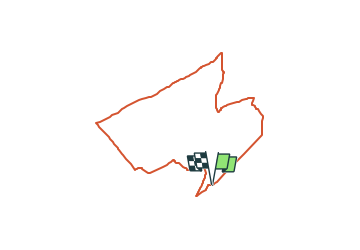
Tocht Te voet van 6,8 km beschikbaar op Noordrijn-Westfalen, Rhein-Sieg-Kreis, Troisdorf. Deze tocht wordt voorgesteld door SityTrail - itinéraires balisés pédestres.
Beschrijving
Trail created by Wahner-Heide Stiftung NRW.
Symbol: Moorlilie gelb auf schwarz
Website: http://www.wahner-heide.com/
Plaatsbepaling
Land:
Germany
Regio :
Noordrijn-Westfalen
Departement/Provincie :
Rhein-Sieg-Kreis
Gemeente :
Troisdorf
Locatie:
Unknown
Vertrek:(Dec)
Vertrek:(UTM)
371553 ; 5637068 (32U) N.
Opmerkingen
Wandeltochten in de omgeving
![Tocht Te voet Lohmar - 18 Bauernhofweg - Photo](https://media.geolcdn.com/t/375/260/771a7b7d-5220-4a2a-b056-9251c7baf4c4.jpeg&format=jpg&maxdim=2)
![Te voet Te voet](https://static1.geolcdn.com/sitytour/trail-icons/100.png)
18 Bauernhofweg
Te voet
Gemakkelijk
Lohmar,
Noordrijn-Westfalen,
Rhein-Sieg-Kreis,
Germany
![](/images/other/stat-length.png)
12,5 km | 16,3 km-effort
3h 42min
![](https://static1.geolcdn.com/siteimages/upload/files/16400158638029165_repeat_loop_refresh_sync_direction_icon.png)
Ja
![Tocht Te voet Lohmar - Heideweg (Erlebnisweg Sieg Nr. 1) - Photo](https://media.geolcdn.com/t/375/260/c3491a3e-eb5a-47ad-9f21-5688e3599986.jpeg&format=jpg&maxdim=2)
![Te voet Te voet](https://static1.geolcdn.com/sitytour/trail-icons/100.png)
Heideweg (Erlebnisweg Sieg Nr. 1)
Te voet
Gemakkelijk
Lohmar,
Noordrijn-Westfalen,
Rhein-Sieg-Kreis,
Germany
![](/images/other/stat-length.png)
8,1 km | 9,4 km-effort
2h 8min
![](https://static1.geolcdn.com/siteimages/upload/files/16400158638029165_repeat_loop_refresh_sync_direction_icon.png)
Neen
![Tocht Te voet Lohmar - Rundweg A3 (Lohmar) - Photo](https://media.geolcdn.com/t/375/260/e2acf4c5-e0b3-46ff-bc92-7e05865bf7a8.jpeg&format=jpg&maxdim=2)
![Te voet Te voet](https://static1.geolcdn.com/sitytour/trail-icons/100.png)
Rundweg A3 (Lohmar)
Te voet
Gemakkelijk
Lohmar,
Noordrijn-Westfalen,
Rhein-Sieg-Kreis,
Germany
![](/images/other/stat-length.png)
6 km | 7 km-effort
1h 35min
![](https://static1.geolcdn.com/siteimages/upload/files/16400158638029165_repeat_loop_refresh_sync_direction_icon.png)
Neen
![Tocht Te voet Lohmar - Rundweg A1 (Lohmar) - Photo](https://media.geolcdn.com/t/375/260/e2acf4c5-e0b3-46ff-bc92-7e05865bf7a8.jpeg&format=jpg&maxdim=2)
![Te voet Te voet](https://static1.geolcdn.com/sitytour/trail-icons/100.png)
Rundweg A1 (Lohmar)
Te voet
Gemakkelijk
Lohmar,
Noordrijn-Westfalen,
Rhein-Sieg-Kreis,
Germany
![](/images/other/stat-length.png)
6,8 km | 8,3 km-effort
1h 52min
![](https://static1.geolcdn.com/siteimages/upload/files/16400158638029165_repeat_loop_refresh_sync_direction_icon.png)
Ja
![Tocht Te voet Rösrath - Rundweg A3 (Honrath) - Photo](https://media.geolcdn.com/t/375/260/771a7b7d-5220-4a2a-b056-9251c7baf4c4.jpeg&format=jpg&maxdim=2)
![Te voet Te voet](https://static1.geolcdn.com/sitytour/trail-icons/100.png)
Rundweg A3 (Honrath)
Te voet
Gemakkelijk
Rösrath,
Noordrijn-Westfalen,
Rheinisch-Bergischer Kreis,
Germany
![](/images/other/stat-length.png)
10,9 km | 14,9 km-effort
3h 23min
![](https://static1.geolcdn.com/siteimages/upload/files/16400158638029165_repeat_loop_refresh_sync_direction_icon.png)
Ja
![Tocht Te voet Troisdorf - Telegraphenberg-Tour - Photo](https://media.geolcdn.com/t/375/260/a86c15df-7786-4e15-983e-67e6043bbdaf.jpeg&format=jpg&maxdim=2)
![Te voet Te voet](https://static1.geolcdn.com/sitytour/trail-icons/100.png)
Telegraphenberg-Tour
Te voet
Gemakkelijk
Troisdorf,
Noordrijn-Westfalen,
Rhein-Sieg-Kreis,
Germany
![](/images/other/stat-length.png)
5,6 km | 6,2 km-effort
1h 24min
![](https://static1.geolcdn.com/siteimages/upload/files/16400158638029165_repeat_loop_refresh_sync_direction_icon.png)
Neen
![Tocht Te voet Rösrath - Geisterbusch-Tour - Photo](https://media.geolcdn.com/t/375/260/49d3912c-be36-4027-a257-770ebf13d974.jpeg&format=jpg&maxdim=2)
![Te voet Te voet](https://static1.geolcdn.com/sitytour/trail-icons/100.png)
Geisterbusch-Tour
Te voet
Gemakkelijk
Rösrath,
Noordrijn-Westfalen,
Rheinisch-Bergischer Kreis,
Germany
![](/images/other/stat-length.png)
3,6 km | 4 km-effort
55min
![](https://static1.geolcdn.com/siteimages/upload/files/16400158638029165_repeat_loop_refresh_sync_direction_icon.png)
Neen
![Tocht Te voet Onbekend - Eichenblatt-Tour - Photo](https://media.geolcdn.com/t/375/260/54188d4b-bb99-49f6-aa15-111a44d137bc.jpeg&format=jpg&maxdim=2)
![Te voet Te voet](https://static1.geolcdn.com/sitytour/trail-icons/100.png)
Eichenblatt-Tour
Te voet
Gemakkelijk
Onbekend,
Noordrijn-Westfalen,
Keulen,
Germany
![](/images/other/stat-length.png)
7,1 km | 7,8 km-effort
1h 46min
![](https://static1.geolcdn.com/siteimages/upload/files/16400158638029165_repeat_loop_refresh_sync_direction_icon.png)
Ja
![Tocht Stappen Rösrath - Rösrath Athénée 5,5 km - Photo](https://media.geolcdn.com/t/375/260/ext.jpg?maxdim=2&url=https%3A%2F%2Fstatic1.geolcdn.com%2Fsiteimages%2Fupload%2Ffiles%2F1553511878bg_sport_marche.png)
![Stappen Stappen](https://static1.geolcdn.com/sitytour/trail-icons/101.png)
Rösrath Athénée 5,5 km
Stappen
Medium
Rösrath,
Noordrijn-Westfalen,
Rheinisch-Bergischer Kreis,
Germany
![](/images/other/stat-length.png)
5,5 km | 6,7 km-effort
1h 27min
![](https://static1.geolcdn.com/siteimages/upload/files/16400158638029165_repeat_loop_refresh_sync_direction_icon.png)
Ja