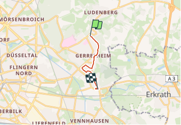
![](/images/other/stat-length.png)
![Tocht Te voet Onbekend - Industriepfad Düsseldorf-Gerresheim - Photo](https://media.geolcdn.com/t/1900/400/d0cb714a-becf-4430-8992-a4b859ea4a1c.jpeg&format=pjpeg&maxdim=2)
Industriepfad Düsseldorf-Gerresheim
SityTrail - itinéraires balisés pédestres
Tous les sentiers balisés d’Europe GUIDE+
![Lengte](/images/other/stat-length.png)
![Max. hoogte](https://static1.geolcdn.com/siteimages/upload/files/1508320355ic_sort_altitude_max_24dp.png)
![Positief hoogteverschil](https://static1.geolcdn.com/siteimages/upload/files/1508320355ic_sort_den_pos_24dp.png)
![Km-Effort](/images/other/stat-length.png)
![Min. hoogte](https://static1.geolcdn.com/siteimages/upload/files/1508320355ic_sort_altitude_min_24dp.png)
![Negatief hoogteverschil](https://static1.geolcdn.com/siteimages/upload/files/1508320355ic_sort_den_neg_24dp.png)
![Boucle](https://static1.geolcdn.com/siteimages/upload/files/16400158638029165_repeat_loop_refresh_sync_direction_icon.png)
![Te voet](https://static1.geolcdn.com/sitytour/trail-icons/100.png)
1h06
Moeilijkheid : Gemakkelijk
![Scan deze QR-code om de tocht te openen in de SityTrail-applicatie](https://capi.geolives.com/qq0zvz2zws4bq2lad0pu/sitytour/trails/3089405/qr.png?size=200)
Gratisgps-wandelapplicatie
Over ons
Tocht Te voet van 4,5 km beschikbaar op Noordrijn-Westfalen, Düsseldorf, Onbekend. Deze tocht wordt voorgesteld door SityTrail - itinéraires balisés pédestres.
Beschrijving
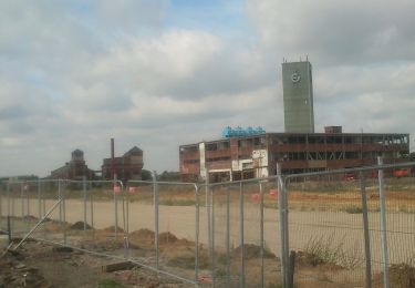
Trail created by Förderkreis Industriepfad Düsseldorf-Gerresheim e.V..
Der Industriepfad kann beim Ringofen noch nicht in seiner endgültigen Führung eingegeben werden, da noch Wege im Neubaugebiet fehlen. Weithin fehlen noch die meisten Informationsstelen.
Plaatsbepaling
Opmerkingen
Wandeltochten in de omgeving
![Tocht Te voet Erkrath - Neanderlandsteig Entdeckerschleife](https://media.geolcdn.com/t/375/260/f0a4c676-b45d-44ca-9d2f-c9554313404f.jpeg&format=jpg&maxdim=2)
![Te voet Te voet](https://static1.geolcdn.com/sitytour/trail-icons/100.png)
Te voet
![](/images/other/stat-length.png)
![](https://static1.geolcdn.com/siteimages/upload/files/16400158638029165_repeat_loop_refresh_sync_direction_icon.png)
![Tocht Te voet Onbekend - Aaperwald Rundweg A2 - Photo](https://media.geolcdn.com/t/375/260/ca0b790a-7d1f-4d5e-b73b-8c860418e106.jpeg&format=jpg&maxdim=2)
![Te voet Te voet](https://static1.geolcdn.com/sitytour/trail-icons/100.png)
Te voet
![](/images/other/stat-length.png)
![](https://static1.geolcdn.com/siteimages/upload/files/16400158638029165_repeat_loop_refresh_sync_direction_icon.png)
![Tocht Te voet Onbekend - Rechteck Gerresheim-Unterbach - Photo](https://media.geolcdn.com/t/375/260/533e878e-0bfb-411b-a976-bd0edf99eb3a.jpeg&format=jpg&maxdim=2)
![Te voet Te voet](https://static1.geolcdn.com/sitytour/trail-icons/100.png)
Te voet
![](/images/other/stat-length.png)
![](https://static1.geolcdn.com/siteimages/upload/files/16400158638029165_repeat_loop_refresh_sync_direction_icon.png)
![Tocht Te voet Erkrath - Rechteck Erkrath-Eller - Photo](https://media.geolcdn.com/t/375/260/869ed9d6-13d5-459e-9f12-6811fc83e378.jpeg&format=jpg&maxdim=2)
![Te voet Te voet](https://static1.geolcdn.com/sitytour/trail-icons/100.png)
Te voet
![](/images/other/stat-length.png)
![](https://static1.geolcdn.com/siteimages/upload/files/16400158638029165_repeat_loop_refresh_sync_direction_icon.png)
![Tocht Te voet Erkrath - Doppelbalken Rund um Alt-Erkrath - Photo](https://media.geolcdn.com/t/375/260/fa6b4399-24c9-49f3-9a97-8e33e8c2dfbf.jpeg&format=jpg&maxdim=2)
![Te voet Te voet](https://static1.geolcdn.com/sitytour/trail-icons/100.png)
Te voet
![](/images/other/stat-length.png)
![](https://static1.geolcdn.com/siteimages/upload/files/16400158638029165_repeat_loop_refresh_sync_direction_icon.png)
![Tocht Te voet Onbekend - Aaperwald Rundweg A1 - Photo](https://media.geolcdn.com/t/375/260/4d07ddde-f9f0-4046-a6db-7f628bc2b8e3.jpeg&format=jpg&maxdim=2)
![Te voet Te voet](https://static1.geolcdn.com/sitytour/trail-icons/100.png)
Te voet
![](/images/other/stat-length.png)
![](https://static1.geolcdn.com/siteimages/upload/files/16400158638029165_repeat_loop_refresh_sync_direction_icon.png)
![Tocht Te voet Onbekend - Aaperwald Rundweg A4 - Photo](https://media.geolcdn.com/t/375/260/cc10fb3b-0b55-4811-9c85-f69bb325738c.jpeg&format=jpg&maxdim=2)
![Te voet Te voet](https://static1.geolcdn.com/sitytour/trail-icons/100.png)
Te voet
![](/images/other/stat-length.png)
![](https://static1.geolcdn.com/siteimages/upload/files/16400158638029165_repeat_loop_refresh_sync_direction_icon.png)
![Tocht Te voet Onbekend - [D] Düsseldorfer Weg - Photo](https://media.geolcdn.com/t/375/260/02398625-9783-4a6b-913e-ce79bc76d8b1.jpeg&format=jpg&maxdim=2)
![Te voet Te voet](https://static1.geolcdn.com/sitytour/trail-icons/100.png)
Te voet
![](/images/other/stat-length.png)
![](https://static1.geolcdn.com/siteimages/upload/files/16400158638029165_repeat_loop_refresh_sync_direction_icon.png)
![Tocht Te voet Erkrath - Vollquadrat Gerresheim-Neanderthal - Photo](https://media.geolcdn.com/t/375/260/d1572fd1-0357-4966-88ad-318e5641457b.jpeg&format=jpg&maxdim=2)
![Te voet Te voet](https://static1.geolcdn.com/sitytour/trail-icons/100.png)
Te voet
![](/images/other/stat-length.png)
![](https://static1.geolcdn.com/siteimages/upload/files/16400158638029165_repeat_loop_refresh_sync_direction_icon.png)