Tocht Te voet Hohenleimbach - [③] Rundweg Heckenbach 3 - Photo

Tous les sentiers balisés d’Europe PRO

© OpenStreetMap contributors
Lengte
Lengte
7,4 km
Max. hoogte
Max. hoogte
655 m
Positief hoogteverschil
106 m
Km-Effort
Km-Effort  
9,6 km
Min. hoogte
Min. hoogte
370 m
Negatief hoogteverschil
324 m
Boucle
Boucle
Neen
Markering
Markering
Datum van aanmaak :
2022-02-11 13:09:49.679
Laatste wijziging :
2022-02-11 13:09:49.679

(0 Bericht)

Te voet
Te voet
2h10
Moeilijkheid : Gemakkelijk

Scan deze QR-code om de tocht te openen in de SityTrail-applicatie

Gratisgps-wandelapplicatie

Logo SityTrail SityTrail

IGN / Geografische instituten

SityTrail uit de App Store downloaden SityTrail uit Google Play downloaden

Logo SityTrail SityTrail World

De wereld gaat voor u open

SityTrail uit de App Store downloaden SityTrail uit Google Play downloaden SityTrail op Huawei AppGallery downloaden

Over ons

Tocht Te voet van 7,4 km beschikbaar op Rijnland-Palts, Landkreis Ahrweiler, Hohenleimbach. Deze tocht wordt voorgesteld door SityTrail - itinéraires balisés pédestres.

Plaatsbepaling

Land:
Germany
Regio :
Rijnland-Palts
Departement/Provincie :
Landkreis Ahrweiler
Gemeente :
Hohenleimbach
Locatie:
Unknown
Vertrek:(UTM)
361647 ; 5586696 (32U) N.

Wandeltochten in de omgeving

Tocht Te voet Langscheid - Wacholderweg - Photo
Te voet
PRO

Te voet

Gemakkelijk
Langscheid, Rijnland-Palts, Landkreis Mayen-Koblenz, Germany
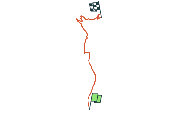
7,2 km | 10,2 km-effort
2h 19min
Neen
Tocht Stappen Arft - Trumpfade Arft et sa rivière à descendre voir.  - Photo
Stappen
Koa1a

Stappen

Gemakkelijk
Arft, Rijnland-Palts, Landkreis Mayen-Koblenz, Germany
10,3 km | 14,3 km-effort
2h 48min
Ja


Sluiten
Mijn abonnementen