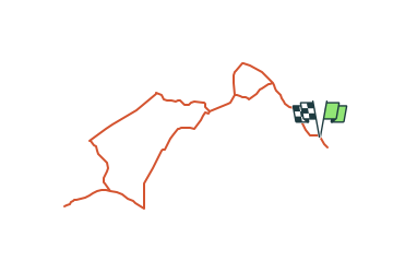
![](/images/other/stat-length.png)
![Tocht Te voet Haibach - Kulturweg Haibach - Photo](https://media.geolcdn.com/t/1900/400/7b9019f3-74d7-40fd-93fc-f3b7a9fc9438.jpeg&format=pjpeg&maxdim=2)
Kulturweg Haibach
SityTrail - itinéraires balisés pédestres
Tous les sentiers balisés d’Europe GUIDE+
![Lengte](/images/other/stat-length.png)
![Max. hoogte](https://static1.geolcdn.com/siteimages/upload/files/1508320355ic_sort_altitude_max_24dp.png)
![Positief hoogteverschil](https://static1.geolcdn.com/siteimages/upload/files/1508320355ic_sort_den_pos_24dp.png)
![Km-Effort](/images/other/stat-length.png)
![Min. hoogte](https://static1.geolcdn.com/siteimages/upload/files/1508320355ic_sort_altitude_min_24dp.png)
![Negatief hoogteverschil](https://static1.geolcdn.com/siteimages/upload/files/1508320355ic_sort_den_neg_24dp.png)
![Boucle](https://static1.geolcdn.com/siteimages/upload/files/16400158638029165_repeat_loop_refresh_sync_direction_icon.png)
![Te voet](https://static1.geolcdn.com/sitytour/trail-icons/100.png)
1h20
Moeilijkheid : Gemakkelijk
![Scan deze QR-code om de tocht te openen in de SityTrail-applicatie](https://capi.geolives.com/qq0zvz2zws4bq2lad0pu/sitytour/trails/3088606/qr.png?size=200)
Gratisgps-wandelapplicatie
Over ons
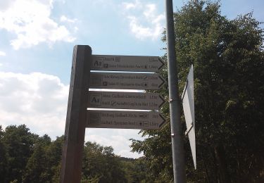
Tocht Te voet van 4,7 km beschikbaar op Beieren, Landkreis Aschaffenburg, Haibach. Deze tocht wordt voorgesteld door SityTrail - itinéraires balisés pédestres.
Beschrijving
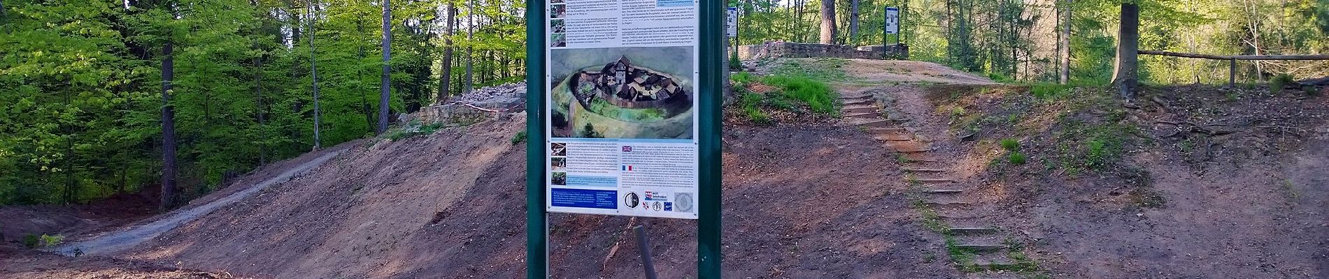
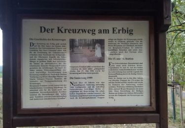
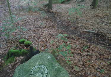
Trail created by Archäologisches Spessartprojekt.
Symbol: Gelbes EU-Schiffchen auf blauem Grund
Website: http://www.spessartprojekt.de/kulturwege/haibach/index.php
Plaatsbepaling
Opmerkingen
Wandeltochten in de omgeving
![Tocht Te voet Haibach - Waldlehrpfad Haibach - Photo](https://media.geolcdn.com/t/375/260/62a06696-8444-4a85-86e3-d7f0481a7431.jpeg&format=jpg&maxdim=2)
![Te voet Te voet](https://static1.geolcdn.com/sitytour/trail-icons/100.png)
Te voet
![](/images/other/stat-length.png)
![](https://static1.geolcdn.com/siteimages/upload/files/16400158638029165_repeat_loop_refresh_sync_direction_icon.png)
![Tocht Te voet Laufach - Frohnhofen Rundwanderweg F1 - Photo](https://media.geolcdn.com/t/375/260/fdff1b94-80a0-4e7f-98b6-b15761402970.jpeg&format=jpg&maxdim=2)
![Te voet Te voet](https://static1.geolcdn.com/sitytour/trail-icons/100.png)
Te voet
![](/images/other/stat-length.png)
![](https://static1.geolcdn.com/siteimages/upload/files/16400158638029165_repeat_loop_refresh_sync_direction_icon.png)
![Tocht Te voet - Roter Schmetterling, Rundwanderweg Schweinheim Erbig - Photo](https://media.geolcdn.com/t/375/260/a9806206-d614-4dd0-9141-a8cd5b92414c.jpeg&format=jpg&maxdim=2)
![Te voet Te voet](https://static1.geolcdn.com/sitytour/trail-icons/100.png)
Te voet
![](/images/other/stat-length.png)
![](https://static1.geolcdn.com/siteimages/upload/files/16400158638029165_repeat_loop_refresh_sync_direction_icon.png)
![Tocht Te voet - Roter Hase, Rundwanderweg Obernauer Wald - Photo](https://media.geolcdn.com/t/375/260/6ab7fb0e-b04a-4632-85e9-d1789f7c9675.jpeg&format=jpg&maxdim=2)
![Te voet Te voet](https://static1.geolcdn.com/sitytour/trail-icons/100.png)
Te voet
![](/images/other/stat-length.png)
![](https://static1.geolcdn.com/siteimages/upload/files/16400158638029165_repeat_loop_refresh_sync_direction_icon.png)
![Tocht Te voet - Roter Schmetterling, Rundwanderweg Aschaffenburg- Schweinheim ehem. StOÜp - Photo](https://media.geolcdn.com/t/375/260/405e058b-0791-4363-82e0-199929cc2c81.jpeg&format=jpg&maxdim=2)
![Te voet Te voet](https://static1.geolcdn.com/sitytour/trail-icons/100.png)
Te voet
![](/images/other/stat-length.png)
![](https://static1.geolcdn.com/siteimages/upload/files/16400158638029165_repeat_loop_refresh_sync_direction_icon.png)
![Tocht Te voet - Rote Schnepfe, Rundwanderweg Aschaffenburg- Schweinheim ehem. StOÜp - Photo](https://media.geolcdn.com/t/375/260/bb41aaed-26ed-45e3-b773-f65441e24930.jpeg&format=jpg&maxdim=2)
![Te voet Te voet](https://static1.geolcdn.com/sitytour/trail-icons/100.png)
Te voet
![](/images/other/stat-length.png)
![](https://static1.geolcdn.com/siteimages/upload/files/16400158638029165_repeat_loop_refresh_sync_direction_icon.png)
![Tocht Te voet Sulzbach am Main - Schwarzer Keiler, Rundwanderweg Soden Wanderheim - Photo](https://media.geolcdn.com/t/375/260/ba5de696-b6bf-45af-9eb3-e414e633ba64.jpeg&format=jpg&maxdim=2)
![Te voet Te voet](https://static1.geolcdn.com/sitytour/trail-icons/100.png)
Te voet
![](/images/other/stat-length.png)
![](https://static1.geolcdn.com/siteimages/upload/files/16400158638029165_repeat_loop_refresh_sync_direction_icon.png)
![Tocht Te voet Sulzbach am Main - Roter Schmetterling, Rundwanderweg Soden - Photo](https://media.geolcdn.com/t/375/260/50bceceb-a4d1-444d-8df7-328621e7e3dd.jpeg&format=jpg&maxdim=2)
![Te voet Te voet](https://static1.geolcdn.com/sitytour/trail-icons/100.png)
Te voet
![](/images/other/stat-length.png)
![](https://static1.geolcdn.com/siteimages/upload/files/16400158638029165_repeat_loop_refresh_sync_direction_icon.png)
![Tocht Te voet - Ortswanderweg Sulzbach 2 - Photo](https://media.geolcdn.com/t/375/260/50bceceb-a4d1-444d-8df7-328621e7e3dd.jpeg&format=jpg&maxdim=2)
![Te voet Te voet](https://static1.geolcdn.com/sitytour/trail-icons/100.png)
Te voet
![](/images/other/stat-length.png)
![](https://static1.geolcdn.com/siteimages/upload/files/16400158638029165_repeat_loop_refresh_sync_direction_icon.png)