![](/images/other/stat-length.png)
![Tocht Te voet Attenhausen - Dörsbach Mühlenwanderweg - Photo](https://media.geolcdn.com/t/1900/400/ext.pjpeg?maxdim=2&url=https%3A%2F%2Fstatic1.geolcdn.com%2Fsiteimages%2Fupload%2Ffiles%2F1545311037marcheuse_200dpi.jpg)
Dörsbach Mühlenwanderweg
SityTrail - itinéraires balisés pédestres
Tous les sentiers balisés d’Europe GUIDE+
![Lengte](/images/other/stat-length.png)
Lengte
7,3 km
![Max. hoogte](https://static1.geolcdn.com/siteimages/upload/files/1508320355ic_sort_altitude_max_24dp.png)
Max. hoogte
280 m
![Positief hoogteverschil](https://static1.geolcdn.com/siteimages/upload/files/1508320355ic_sort_den_pos_24dp.png)
Positief hoogteverschil
192 m
![Km-Effort](/images/other/stat-length.png)
Km-Effort
9,5 km
![Min. hoogte](https://static1.geolcdn.com/siteimages/upload/files/1508320355ic_sort_altitude_min_24dp.png)
Min. hoogte
155 m
![Negatief hoogteverschil](https://static1.geolcdn.com/siteimages/upload/files/1508320355ic_sort_den_neg_24dp.png)
Negatief hoogteverschil
86 m
![Boucle](https://static1.geolcdn.com/siteimages/upload/files/16400158638029165_repeat_loop_refresh_sync_direction_icon.png)
Boucle
Neen
Markering
Datum van aanmaak :
2022-02-11 12:52:52.432
Laatste wijziging :
2022-02-11 12:52:52.432
![Te voet](https://static1.geolcdn.com/sitytour/trail-icons/100.png)
2h10
Moeilijkheid : Gemakkelijk
![Scan deze QR-code om de tocht te openen in de SityTrail-applicatie](https://capi.geolives.com/qq0zvz2zws4bq2lad0pu/sitytour/trails/3088322/qr.png?size=200)
Gratisgps-wandelapplicatie
Over ons
Tocht Te voet van 7,3 km beschikbaar op Rijnland-Palts, Rhein-Lahn-Kreis, Attenhausen. Deze tocht wordt voorgesteld door SityTrail - itinéraires balisés pédestres.
Beschrijving
Trail created by unknown.
Symbol: gelb auf blauem Schild: Oben ein als angeschnittenes Mühlrad dargestelltes "D", darunter "Dörsbach -", darunter "Mühlenwanderweg", darunter Richtungspfeil
Plaatsbepaling
Land:
Germany
Regio :
Rijnland-Palts
Departement/Provincie :
Rhein-Lahn-Kreis
Gemeente :
Attenhausen
Locatie:
Unknown
Vertrek:(Dec)
Vertrek:(UTM)
419701 ; 5570442 (32U) N.
Opmerkingen
Wandeltochten in de omgeving
![Tocht Te voet Obernhof - Vier-Täler-Tour - Photo](https://media.geolcdn.com/t/375/260/1062c10a-15c8-4924-a2ee-6396706e86c8.jpeg&format=jpg&maxdim=2)
![Te voet Te voet](https://static1.geolcdn.com/sitytour/trail-icons/100.png)
Vier-Täler-Tour
Te voet
Medium
Obernhof,
Rijnland-Palts,
Rhein-Lahn-Kreis,
Germany
![](/images/other/stat-length.png)
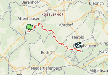
18,2 km | 24 km-effort
5h 26min
![](https://static1.geolcdn.com/siteimages/upload/files/16400158638029165_repeat_loop_refresh_sync_direction_icon.png)
Neen
![Tocht Te voet Obernhof - Gelbachhöhen-Tour - Photo](https://media.geolcdn.com/t/375/260/6c8be9c2-44c7-4314-b336-6552d9905e3c.jpeg&format=jpg&maxdim=2)
![Te voet Te voet](https://static1.geolcdn.com/sitytour/trail-icons/100.png)
Gelbachhöhen-Tour
Te voet
Gemakkelijk
Obernhof,
Rijnland-Palts,
Rhein-Lahn-Kreis,
Germany
![](/images/other/stat-length.png)
11,8 km | 17,1 km-effort
3h 52min
![](https://static1.geolcdn.com/siteimages/upload/files/16400158638029165_repeat_loop_refresh_sync_direction_icon.png)
Ja
![Tocht Te voet Seelbach - Klosterweg - Photo](https://media.geolcdn.com/t/375/260/e252bca3-2555-46c9-b515-f8887917da9f.jpeg&format=jpg&maxdim=2)
![Te voet Te voet](https://static1.geolcdn.com/sitytour/trail-icons/100.png)
Klosterweg
Te voet
Gemakkelijk
Seelbach,
Rijnland-Palts,
Rhein-Lahn-Kreis,
Germany
![](/images/other/stat-length.png)
14,9 km | 19,5 km-effort
4h 26min
![](https://static1.geolcdn.com/siteimages/upload/files/16400158638029165_repeat_loop_refresh_sync_direction_icon.png)
Ja
![Tocht Fiets Obernhof - Duitsland - Lahntal - Photo](https://media.geolcdn.com/t/375/260/ext.jpg?maxdim=2&url=https%3A%2F%2Fstatic1.geolcdn.com%2Fsiteimages%2Fupload%2Ffiles%2F1524743154velo.jpg)
![Fiets Fiets](https://static1.geolcdn.com/sitytour/trail-icons/200.png)
Duitsland - Lahntal
Fiets
Heel gemakkelijk
Obernhof,
Rijnland-Palts,
Rhein-Lahn-Kreis,
Germany
![](/images/other/stat-length.png)
186 km | 235 km-effort
Onbekend
![](https://static1.geolcdn.com/siteimages/upload/files/16400158638029165_repeat_loop_refresh_sync_direction_icon.png)
Neen