


4,3 km | 4,8 km-effort
![Tocht Te voet Menden - [A7] im Stadtwald Neheim - Photo](https://media.geolcdn.com/t/1900/400/1df3787c-7ea3-4687-aebc-0b7544580bac.jpeg&format=pjpeg&maxdim=2)

Tous les sentiers balisés d’Europe GUIDE+


Gratisgps-wandelapplicatie
 SityTrail
IGN / Geografische instituten
SityTrail World
De wereld gaat voor u open
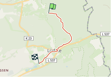
Tocht Te voet van 3,3 km beschikbaar op Noordrijn-Westfalen, Märkischer Kreis, Menden. Deze tocht wordt voorgesteld door SityTrail - itinéraires balisés pédestres.
Trail created by Sauerländischer Gebirgsverein.
Symbol: Weißes A7 auf schwarzem Grund
![Tocht Te voet Menden - [A7] im Stadtwald Neheim - Photo 1](https://media.geolcdn.com/t/2048/auto/67058d27-f24d-45b9-89ad-2b6ca7f6e7a0.jpeg&format=jpg&maxdim=0 "Tocht Te voet Menden - [A7] im Stadtwald Neheim - Photo 1")
![Tocht Te voet Menden - [A7] im Stadtwald Neheim - Photo 2](https://media.geolcdn.com/t/2048/auto/e28b2614-8300-4f4b-8291-355c877a3a95.jpeg&format=jpg&maxdim=0 "Tocht Te voet Menden - [A7] im Stadtwald Neheim - Photo 2")
![Tocht Te voet Menden - [A7] im Stadtwald Neheim - Photo 3](https://media.geolcdn.com/t/2048/auto/1df3787c-7ea3-4687-aebc-0b7544580bac.jpeg&format=jpg&maxdim=0 "Tocht Te voet Menden - [A7] im Stadtwald Neheim - Photo 3")
![Tocht Te voet Menden - [A7] im Stadtwald Neheim - Photo 4](https://media.geolcdn.com/t/2048/auto/6af99ce0-884e-4322-8a32-b9d30da238d9.jpeg&format=jpg&maxdim=0 "Tocht Te voet Menden - [A7] im Stadtwald Neheim - Photo 4")
![Tocht Te voet Menden - [A7] im Stadtwald Neheim - Photo 5](https://media.geolcdn.com/t/2048/auto/60ea5a2e-2099-49e3-827a-12d0c5b3e5ee.jpeg&format=jpg&maxdim=0 "Tocht Te voet Menden - [A7] im Stadtwald Neheim - Photo 5")
![Tocht Te voet Menden - [A7] im Stadtwald Neheim - Photo 6](https://media.geolcdn.com/t/2048/auto/690bed99-4a19-4a63-a519-5144ff5902e1.jpeg&format=jpg&maxdim=0 "Tocht Te voet Menden - [A7] im Stadtwald Neheim - Photo 6")
![Tocht Te voet Menden - [A7] im Stadtwald Neheim - Photo 7](https://media.geolcdn.com/t/2048/auto/e62146cf-23cc-4ee1-a5fc-d918de96e138.jpeg&format=jpg&maxdim=0 "Tocht Te voet Menden - [A7] im Stadtwald Neheim - Photo 7")
![Tocht Te voet Menden - [A7] im Stadtwald Neheim - Photo 8](https://media.geolcdn.com/t/2048/auto/314cb212-7ae0-48c2-bfce-ecb7938b21c1.jpeg&format=jpg&maxdim=0 "Tocht Te voet Menden - [A7] im Stadtwald Neheim - Photo 8")
![Tocht Te voet Menden - [A7] im Stadtwald Neheim - Photo 9](https://media.geolcdn.com/t/2048/auto/e05e8e24-a844-4c38-83e1-f29d79e89958.jpeg&format=jpg&maxdim=0 "Tocht Te voet Menden - [A7] im Stadtwald Neheim - Photo 9")
![Tocht Te voet Menden - [A7] im Stadtwald Neheim - Photo 10](https://media.geolcdn.com/t/2048/auto/79ab70c9-750e-4469-ae3c-73cec367c295.jpeg&format=jpg&maxdim=0 "Tocht Te voet Menden - [A7] im Stadtwald Neheim - Photo 10")
![Tocht Te voet Arnsberg - [Dreieck] - Photo](https://media.geolcdn.com/t/375/260/d81aec76-bcc3-4142-a7ee-5c25b52faed3.jpeg&format=jpg&maxdim=2)
Te voet
Te voet
Te voet
Te voet

Te voet
![Tocht Te voet Menden - [A8] im Stadtwald Neheim - Photo](https://media.geolcdn.com/t/375/260/2d66c466-b78f-43e0-bcea-e76d5a8507c4.jpeg&format=jpg&maxdim=2)
Te voet
![Tocht Te voet Arnsberg - [Quadrat] Luerwald Rundweg - Photo](https://media.geolcdn.com/t/375/260/956801ea-cad4-4d8d-ac8e-4517bcdfc5db.jpeg&format=jpg&maxdim=2)
Te voet
Te voet
Te voet