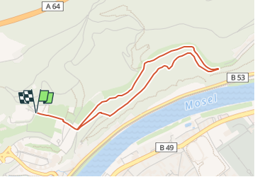
![](/images/other/stat-length.png)
![Tocht Te voet Onbekend - W1 Falsches Biewertal - Photo](https://media.geolcdn.com/t/1900/400/e4800cf7-e6fa-46d7-a198-9e4cd0aed03f.jpeg&format=pjpeg&maxdim=2)
W1 Falsches Biewertal
SityTrail - itinéraires balisés pédestres
Tous les sentiers balisés d’Europe GUIDE+
![Lengte](/images/other/stat-length.png)
![Max. hoogte](https://static1.geolcdn.com/siteimages/upload/files/1508320355ic_sort_altitude_max_24dp.png)
![Positief hoogteverschil](https://static1.geolcdn.com/siteimages/upload/files/1508320355ic_sort_den_pos_24dp.png)
![Km-Effort](/images/other/stat-length.png)
![Min. hoogte](https://static1.geolcdn.com/siteimages/upload/files/1508320355ic_sort_altitude_min_24dp.png)
![Negatief hoogteverschil](https://static1.geolcdn.com/siteimages/upload/files/1508320355ic_sort_den_neg_24dp.png)
![Boucle](https://static1.geolcdn.com/siteimages/upload/files/16400158638029165_repeat_loop_refresh_sync_direction_icon.png)
![Te voet](https://static1.geolcdn.com/sitytour/trail-icons/100.png)
1h13
Moeilijkheid : Gemakkelijk
![Scan deze QR-code om de tocht te openen in de SityTrail-applicatie](https://capi.geolives.com/qq0zvz2zws4bq2lad0pu/sitytour/trails/3088180/qr.png?size=200)
Gratisgps-wandelapplicatie
Over ons
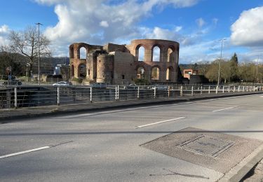
Tocht Te voet van 4,1 km beschikbaar op Rijnland-Palts, Trier, Onbekend. Deze tocht wordt voorgesteld door SityTrail - itinéraires balisés pédestres.
Beschrijving
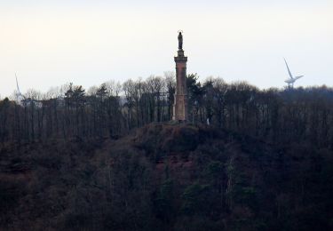
Herzlich willkommen in Trier, der ältesten Stadt Deutschlands. Hier erhalten Sie Informationen rund um Sehenswürdigkeiten, Aktivitäten, Events und vielem mehr.
Website: https://www.trier-info.de/tl_files/downloads/weisshauswald_nordic-walking.pdf
Plaatsbepaling
Opmerkingen
Wandeltochten in de omgeving
![Tocht Te voet Onbekend - Trier Wanderweg T3 (Weißhausbrunnen) - Photo](https://media.geolcdn.com/t/375/260/f16ae428-3afe-44c7-b189-a2e2beae78d1.jpeg&format=jpg&maxdim=2)
![Te voet Te voet](https://static1.geolcdn.com/sitytour/trail-icons/100.png)
Te voet
![](/images/other/stat-length.png)
![](https://static1.geolcdn.com/siteimages/upload/files/16400158638029165_repeat_loop_refresh_sync_direction_icon.png)
![Tocht Te voet Onbekend - Trier Wanderweg T2 (Euren Helenenbrunnen - Napoleonsbrücke B51) - Photo](https://media.geolcdn.com/t/375/260/5d176e1b-4709-4304-904b-f04251bcbdae.jpeg&format=jpg&maxdim=2)
![Te voet Te voet](https://static1.geolcdn.com/sitytour/trail-icons/100.png)
Te voet
![](/images/other/stat-length.png)
![](https://static1.geolcdn.com/siteimages/upload/files/16400158638029165_repeat_loop_refresh_sync_direction_icon.png)
![Tocht Te voet Onbekend - Trier Wanderweg T1 (Weißhausbrunnen) - Photo](https://media.geolcdn.com/t/375/260/c8e0d73d-cd1d-4fa8-8395-4650d1b8e2e2.jpeg&format=jpg&maxdim=2)
![Te voet Te voet](https://static1.geolcdn.com/sitytour/trail-icons/100.png)
Te voet
![](/images/other/stat-length.png)
![](https://static1.geolcdn.com/siteimages/upload/files/16400158638029165_repeat_loop_refresh_sync_direction_icon.png)
![Tocht Te voet Onbekend - W3 Moselblick - Photo](https://media.geolcdn.com/t/375/260/e4800cf7-e6fa-46d7-a198-9e4cd0aed03f.jpeg&format=jpg&maxdim=2)
![Te voet Te voet](https://static1.geolcdn.com/sitytour/trail-icons/100.png)
Te voet
![](/images/other/stat-length.png)
![](https://static1.geolcdn.com/siteimages/upload/files/16400158638029165_repeat_loop_refresh_sync_direction_icon.png)
![Tocht Te voet Onbekend - W2 Weisshauswald - Photo](https://media.geolcdn.com/t/375/260/e4800cf7-e6fa-46d7-a198-9e4cd0aed03f.jpeg&format=jpg&maxdim=2)
![Te voet Te voet](https://static1.geolcdn.com/sitytour/trail-icons/100.png)
Te voet
![](/images/other/stat-length.png)
![](https://static1.geolcdn.com/siteimages/upload/files/16400158638029165_repeat_loop_refresh_sync_direction_icon.png)
![Tocht Te voet Onbekend - Trier Wanderweg T9 - Photo](https://media.geolcdn.com/t/375/260/5708691f-95da-4a71-a4fc-a7618c703f95.jpeg&format=jpg&maxdim=2)
![Te voet Te voet](https://static1.geolcdn.com/sitytour/trail-icons/100.png)
Te voet
![](/images/other/stat-length.png)
![](https://static1.geolcdn.com/siteimages/upload/files/16400158638029165_repeat_loop_refresh_sync_direction_icon.png)
![Tocht Stappen Onbekend - leonie de waha en goguette à Trêves - Photo](https://media.geolcdn.com/t/375/260/c7252f03-9f99-4ec8-af24-3955b8f036d9.jpg&format=jpg&maxdim=2)
![Stappen Stappen](https://static1.geolcdn.com/sitytour/trail-icons/101.png)
Stappen
![](/images/other/stat-length.png)
![](https://static1.geolcdn.com/siteimages/upload/files/16400158638029165_repeat_loop_refresh_sync_direction_icon.png)
![Tocht Stappen Onbekend - Trêves -Allemagne - Photo](https://media.geolcdn.com/t/375/260/9a6d7f05-4213-4263-93a2-7226c5f1fc0a.jpg&format=jpg&maxdim=2)
![Stappen Stappen](https://static1.geolcdn.com/sitytour/trail-icons/101.png)
Stappen
![](/images/other/stat-length.png)
![](https://static1.geolcdn.com/siteimages/upload/files/16400158638029165_repeat_loop_refresh_sync_direction_icon.png)
![Tocht Te voet Onbekend - Trier Wanderweg T5 (Trier Weißhausbrunnen - Ehrang) - Photo](https://media.geolcdn.com/t/375/260/ext.jpg?maxdim=2&url=https%3A%2F%2Fstatic1.geolcdn.com%2Fsiteimages%2Fupload%2Ffiles%2F1545311037marcheuse_200dpi.jpg)
![Te voet Te voet](https://static1.geolcdn.com/sitytour/trail-icons/100.png)
Te voet
![](/images/other/stat-length.png)
![](https://static1.geolcdn.com/siteimages/upload/files/16400158638029165_repeat_loop_refresh_sync_direction_icon.png)