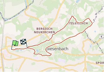
![](/images/other/stat-length.png)
![Tocht Te voet Onbekend - Obstweg Leverkusen - Photo](https://media.geolcdn.com/t/1900/400/46f237d9-b111-4e3d-a3b2-45f68d5a6a13.jpeg&format=pjpeg&maxdim=2)
Obstweg Leverkusen
SityTrail - itinéraires balisés pédestres
Tous les sentiers balisés d’Europe GUIDE+
![Lengte](/images/other/stat-length.png)
![Max. hoogte](https://static1.geolcdn.com/siteimages/upload/files/1508320355ic_sort_altitude_max_24dp.png)
![Positief hoogteverschil](https://static1.geolcdn.com/siteimages/upload/files/1508320355ic_sort_den_pos_24dp.png)
![Km-Effort](/images/other/stat-length.png)
![Min. hoogte](https://static1.geolcdn.com/siteimages/upload/files/1508320355ic_sort_altitude_min_24dp.png)
![Negatief hoogteverschil](https://static1.geolcdn.com/siteimages/upload/files/1508320355ic_sort_den_neg_24dp.png)
![Boucle](https://static1.geolcdn.com/siteimages/upload/files/16400158638029165_repeat_loop_refresh_sync_direction_icon.png)
![Te voet](https://static1.geolcdn.com/sitytour/trail-icons/100.png)
2h11
Moeilijkheid : Gemakkelijk
![Scan deze QR-code om de tocht te openen in de SityTrail-applicatie](https://capi.geolives.com/qq0zvz2zws4bq2lad0pu/sitytour/trails/3088147/qr.png?size=200)
Gratisgps-wandelapplicatie
Over ons
Tocht Te voet van 8,3 km beschikbaar op Noordrijn-Westfalen, Leverkusen, Onbekend. Deze tocht wordt voorgesteld door SityTrail - itinéraires balisés pédestres.
Beschrijving
Trail created by NABU-Naturschutzstaion Rhein-Berg.
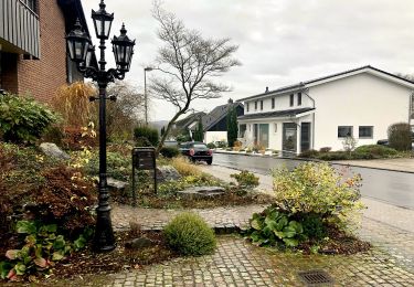
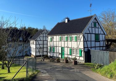
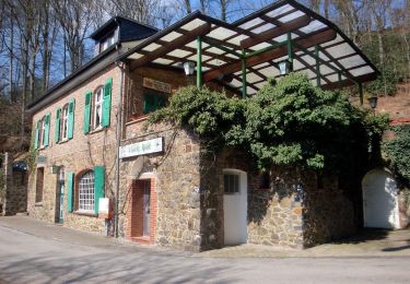
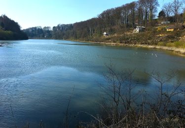
Führt ausgehend vom NaturGut Ophoven in Leverkusen-Opladen durch Täler und über Hügel durch eine reizvolle und abwechslungsreiche Landschaft.
Symbol: weißer Apfel auf schwarzem Grund
Plaatsbepaling
Opmerkingen
Wandeltochten in de omgeving
![Tocht Te voet Leichlingen - Weltersbachtal Rundweg A2 - Photo](https://media.geolcdn.com/t/375/260/062cb71c-bb6f-4b1d-b073-db90087cbcd1.jpeg&format=jpg&maxdim=2)
![Te voet Te voet](https://static1.geolcdn.com/sitytour/trail-icons/100.png)
Te voet
![](/images/other/stat-length.png)
![](https://static1.geolcdn.com/siteimages/upload/files/16400158638029165_repeat_loop_refresh_sync_direction_icon.png)
![Tocht Te voet Onbekend - Bergisch-Neukirchen Rundweg A8 - Photo](https://media.geolcdn.com/t/375/260/1c9f756c-9f0a-4258-a5eb-501dc87f2896.jpeg&format=jpg&maxdim=2)
![Te voet Te voet](https://static1.geolcdn.com/sitytour/trail-icons/100.png)
Te voet
![](/images/other/stat-length.png)
![](https://static1.geolcdn.com/siteimages/upload/files/16400158638029165_repeat_loop_refresh_sync_direction_icon.png)
![Tocht Te voet Onbekend - Bergisch-Neukirchen Rundweg A7 - Photo](https://media.geolcdn.com/t/375/260/fdc265b1-c0df-4597-80be-c7603647c272.jpeg&format=jpg&maxdim=2)
![Te voet Te voet](https://static1.geolcdn.com/sitytour/trail-icons/100.png)
Te voet
![](/images/other/stat-length.png)
![](https://static1.geolcdn.com/siteimages/upload/files/16400158638029165_repeat_loop_refresh_sync_direction_icon.png)
![Tocht Te voet Burscheid - Rund um Leverkusen LV - Photo](https://media.geolcdn.com/t/375/260/e271cf7c-36e9-4684-b7a3-58d301fa4816.jpeg&format=jpg&maxdim=2)
![Te voet Te voet](https://static1.geolcdn.com/sitytour/trail-icons/100.png)
Te voet
![](/images/other/stat-length.png)
![](https://static1.geolcdn.com/siteimages/upload/files/16400158638029165_repeat_loop_refresh_sync_direction_icon.png)
![Tocht Te voet Burscheid - Rundweg Burscheid - Lützenkirchen - Photo](https://media.geolcdn.com/t/375/260/9af085b3-fcd3-4d2e-924c-0a3655247afc.jpeg&format=jpg&maxdim=2)
![Te voet Te voet](https://static1.geolcdn.com/sitytour/trail-icons/100.png)
Te voet
![](/images/other/stat-length.png)
![](https://static1.geolcdn.com/siteimages/upload/files/16400158638029165_repeat_loop_refresh_sync_direction_icon.png)
![Tocht Te voet Onbekend - Naturfreundeweg Neuenkamp - Rath/Heumar - Photo](https://media.geolcdn.com/t/375/260/ext.jpg?maxdim=2&url=https%3A%2F%2Fupload.wikimedia.org%2Fwikipedia%2Fcommons%2Fthumb%2F6%2F68%2FAston_Martin_SP10_Roadster.jpg%2F2000px-Aston_Martin_SP10_Roadster.jpg)
![Te voet Te voet](https://static1.geolcdn.com/sitytour/trail-icons/100.png)
Te voet
![](/images/other/stat-length.png)
![](https://static1.geolcdn.com/siteimages/upload/files/16400158638029165_repeat_loop_refresh_sync_direction_icon.png)
![Tocht Te voet Leichlingen - Naturfreundeweg Leverkusen - Photo](https://media.geolcdn.com/t/375/260/c19f38bd-78ef-4887-a523-749dc2f2c8e3.jpeg&format=jpg&maxdim=2)
![Te voet Te voet](https://static1.geolcdn.com/sitytour/trail-icons/100.png)
Te voet
![](/images/other/stat-length.png)
![](https://static1.geolcdn.com/siteimages/upload/files/16400158638029165_repeat_loop_refresh_sync_direction_icon.png)
![Tocht Te voet Onbekend - Bergisch-Neukirchen Rundweg A1 - Photo](https://media.geolcdn.com/t/375/260/7c80817f-8afe-4746-9dfe-41f5b18539cf.jpeg&format=jpg&maxdim=2)
![Te voet Te voet](https://static1.geolcdn.com/sitytour/trail-icons/100.png)
Te voet
![](/images/other/stat-length.png)
![](https://static1.geolcdn.com/siteimages/upload/files/16400158638029165_repeat_loop_refresh_sync_direction_icon.png)
![Tocht Te voet Onbekend - (BN) Rund um Bergisch-Neukirchen - Photo](https://media.geolcdn.com/t/375/260/75a5e3e8-3fd2-4666-a613-a383730390fe.jpeg&format=jpg&maxdim=2)
![Te voet Te voet](https://static1.geolcdn.com/sitytour/trail-icons/100.png)
Te voet
![](/images/other/stat-length.png)
![](https://static1.geolcdn.com/siteimages/upload/files/16400158638029165_repeat_loop_refresh_sync_direction_icon.png)