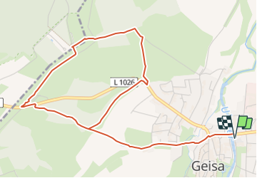
![](/images/other/stat-length.png)
![Tocht Te voet Geisa - Geisaer Amt - Rundwanderweg 1 - Photo](https://media.geolcdn.com/t/1900/400/77f76525-5a75-48be-bd81-98a51a9d7e03.jpeg&format=pjpeg&maxdim=2)
Geisaer Amt - Rundwanderweg 1
SityTrail - itinéraires balisés pédestres
Tous les sentiers balisés d’Europe GUIDE+
![Lengte](/images/other/stat-length.png)
![Max. hoogte](https://static1.geolcdn.com/siteimages/upload/files/1508320355ic_sort_altitude_max_24dp.png)
![Positief hoogteverschil](https://static1.geolcdn.com/siteimages/upload/files/1508320355ic_sort_den_pos_24dp.png)
![Km-Effort](/images/other/stat-length.png)
![Min. hoogte](https://static1.geolcdn.com/siteimages/upload/files/1508320355ic_sort_altitude_min_24dp.png)
![Negatief hoogteverschil](https://static1.geolcdn.com/siteimages/upload/files/1508320355ic_sort_den_neg_24dp.png)
![Boucle](https://static1.geolcdn.com/siteimages/upload/files/16400158638029165_repeat_loop_refresh_sync_direction_icon.png)
![Te voet](https://static1.geolcdn.com/sitytour/trail-icons/100.png)
1h50
Moeilijkheid : Gemakkelijk
![Scan deze QR-code om de tocht te openen in de SityTrail-applicatie](https://capi.geolives.com/qq0zvz2zws4bq2lad0pu/sitytour/trails/3087780/qr.png?size=200)
Gratisgps-wandelapplicatie
Over ons
Tocht Te voet van 5,8 km beschikbaar op Thüringen, Wartburgkreis, Geisa. Deze tocht wordt voorgesteld door SityTrail - itinéraires balisés pédestres.
Beschrijving
Trail created by Rhönklub.
Symbol: Weiße 1 auf blauem Grund
Website: http://www.stadt-geisa.org/www/tourismus-freizeit/verzeichnisse/rad-wanderwege-a-lehrpfade/item/rundwanderweg-1.html?category_id=10&jjj=1571658931707
Plaatsbepaling
Opmerkingen
Wandeltochten in de omgeving
![Tocht Te voet Rasdorf - Rasdorf - Rhön-Rundweg 2 - Photo](https://media.geolcdn.com/t/375/260/40fd2630-a06d-4358-8258-98f1943e96c3.jpeg&format=jpg&maxdim=2)
![Te voet Te voet](https://static1.geolcdn.com/sitytour/trail-icons/100.png)
Te voet
![](/images/other/stat-length.png)
![](https://static1.geolcdn.com/siteimages/upload/files/16400158638029165_repeat_loop_refresh_sync_direction_icon.png)
![Tocht Te voet Buttlar - Grenzlehrpfad - Photo](https://media.geolcdn.com/t/375/260/77f76525-5a75-48be-bd81-98a51a9d7e03.jpeg&format=jpg&maxdim=2)
![Te voet Te voet](https://static1.geolcdn.com/sitytour/trail-icons/100.png)
Te voet
![](/images/other/stat-length.png)
![](https://static1.geolcdn.com/siteimages/upload/files/16400158638029165_repeat_loop_refresh_sync_direction_icon.png)
![Tocht Te voet Schleid - Geisaer Amt - Rundwanderweg 2 - Photo](https://media.geolcdn.com/t/375/260/c4229eb8-ddb6-4962-8900-defe2953da25.jpeg&format=jpg&maxdim=2)
![Te voet Te voet](https://static1.geolcdn.com/sitytour/trail-icons/100.png)
Te voet
![](/images/other/stat-length.png)
![](https://static1.geolcdn.com/siteimages/upload/files/16400158638029165_repeat_loop_refresh_sync_direction_icon.png)
![Tocht Te voet Geisa - Extratour Point-Alpha-Weg - Photo](https://media.geolcdn.com/t/375/260/77f76525-5a75-48be-bd81-98a51a9d7e03.jpeg&format=jpg&maxdim=2)
![Te voet Te voet](https://static1.geolcdn.com/sitytour/trail-icons/100.png)
Te voet
![](/images/other/stat-length.png)
![](https://static1.geolcdn.com/siteimages/upload/files/16400158638029165_repeat_loop_refresh_sync_direction_icon.png)
![Tocht Te voet Rasdorf - Rundweg 1, Setzelbach - Photo](https://media.geolcdn.com/t/375/260/ebe04403-ddd9-42f4-83a7-f7841c87ee31.jpeg&format=jpg&maxdim=2)
![Te voet Te voet](https://static1.geolcdn.com/sitytour/trail-icons/100.png)
Te voet
![](/images/other/stat-length.png)
![](https://static1.geolcdn.com/siteimages/upload/files/16400158638029165_repeat_loop_refresh_sync_direction_icon.png)