Tocht  Fontainebleau - R2-Epine-Cuvier - Photo
 abethuys
abethuys

Gebruiker

© OpenStreetMap contributors
Lengte
Lengte
13,5 km
Max. hoogte
Max. hoogte
149 m
Positief hoogteverschil
227 m
Km-Effort
Km-Effort  
16,5 km
Min. hoogte
Min. hoogte
89 m
Negatief hoogteverschil
228 m
Boucle
Boucle
Ja
Datum van aanmaak :
2022-02-10 11:06:55.283
Laatste wijziging :
2022-02-10 11:06:55.283

(0 Bericht)


Scan deze QR-code om de tocht te openen in de SityTrail-applicatie

Gratisgps-wandelapplicatie

Logo SityTrail SityTrail

IGN / Geografische instituten

SityTrail uit de App Store downloaden SityTrail uit Google Play downloaden

Logo SityTrail SityTrail World

De wereld gaat voor u open

SityTrail uit de App Store downloaden SityTrail uit Google Play downloaden SityTrail op Huawei AppGallery downloaden

Over ons

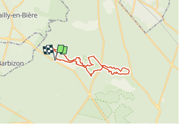
Tocht van 13,5 km beschikbaar op Île-de-France, Seine-et-Marne, Fontainebleau. Deze tocht wordt voorgesteld door abethuys.

Hoogteprofiel

POI's

POI Fontainebleau - Mise en garde N°2 - Photo
abethuys
FONTAINEBLEAU 
POI Fontainebleau - Mise en garde N°1 - Photo
abethuys
FONTAINEBLEAU 

Plaatsbepaling

Land:
France
Regio :
Île-de-France
Departement/Provincie :
Seine-et-Marne
Gemeente :
Fontainebleau
Locatie:
Unknown
Vertrek:(Dec)
Vertrek:(UTM)
473197 ; 5365938 (31U) N.

Wandeltochten in de omgeving

Tocht Stappen Barbizon - Sentier des peintres - Photo
Stappen
onftest

Stappen

Medium
(11)
Barbizon, Île-de-France, Seine-et-Marne, France
7,5 km | 8,2 km-effort
1h 25min
Ja
Tocht Stappen Fontainebleau - Sur les traces de Césaire Sempité - Fontainebleau rocher canon - Photo
Stappen
GUIDE
chessyca

Stappen

Gemakkelijk
(1)
Fontainebleau, Île-de-France, Seine-et-Marne, France
17,3 km | 21 km-effort
4h 8min
Ja
Tocht Stappen Fontainebleau - 3pi-150428 - DésertApremont-Jupiter - Photo
Stappen
randodan

Stappen

Gemakkelijk
(1)
Fontainebleau, Île-de-France, Seine-et-Marne, France
16 km | 19,4 km-effort
6h 30min
Ja
Tocht Te voet Fontainebleau - Fontainebleau les monts de Fay - Photo
Te voet
GUIDE
chessyca

Te voet

Medium
Fontainebleau, Île-de-France, Seine-et-Marne, France
22 km | 27 km-effort
6h 12min
Ja
Tocht Te voet Fontainebleau - Rando des trois châteaux parcours 42 km Fontainebleau Vaux le vicomte Blandy les tours - Photo
Te voet
GUIDE
chessyca

Te voet

Zeer moeilijk
Fontainebleau, Île-de-France, Seine-et-Marne, France
43 km | 50 km-effort
11h 23min
Neen
Tocht Stappen Fontainebleau - Boucle Fontainebleau - Photo
Stappen
GUIDE
chessyca

Stappen

Medium
Fontainebleau, Île-de-France, Seine-et-Marne, France
29 km | 34 km-effort
5h 49min
Ja
Tocht Te voet Fontainebleau - SityTrail - JC 60 Fontainebleau, les rochers du long boyau, du Mt Morillon, des Demoiselles... - Photo
Te voet

Te voet

Moeilijk
(2)
Fontainebleau, Île-de-France, Seine-et-Marne, France
14,6 km | 17,3 km-effort
3h 56min
Ja
Tocht Stappen Fontainebleau - La rando des 3 chateaux - Parcours 42 km - Photo
Stappen
GUIDE
chessyca

Stappen

Zeer moeilijk
Fontainebleau, Île-de-France, Seine-et-Marne, France
43 km | 49 km-effort
7h 37min
Neen
Tocht Stappen Barbizon - Le tour du Grand Paris via le GR1 etape 14 Barbizon- Malesherbes - Photo
Stappen
GUIDE
chessyca

Stappen

Zeer moeilijk
Barbizon, Île-de-France, Seine-et-Marne, France
35 km | 41 km-effort
6h 11min
Neen


Sluiten
Mijn abonnementen