![](/images/other/stat-length.png)
![Tocht Te voet Sprimont - Vallon des Chantoirs - Photo](https://media.geolcdn.com/t/1900/400/6ed13be7-a004-4fae-a47b-033d1e34eb7a.jpeg&format=pjpeg&maxdim=2)
Vallon des Chantoirs
SityTrail - itinéraires balisés pédestres
Tous les sentiers balisés d’Europe GUIDE+
![Lengte](/images/other/stat-length.png)
Lengte
6,4 km
![Max. hoogte](https://static1.geolcdn.com/siteimages/upload/files/1508320355ic_sort_altitude_max_24dp.png)
Max. hoogte
314 m
![Positief hoogteverschil](https://static1.geolcdn.com/siteimages/upload/files/1508320355ic_sort_den_pos_24dp.png)
Positief hoogteverschil
90 m
![Km-Effort](/images/other/stat-length.png)
Km-Effort
7,6 km
![Min. hoogte](https://static1.geolcdn.com/siteimages/upload/files/1508320355ic_sort_altitude_min_24dp.png)
Min. hoogte
241 m
![Negatief hoogteverschil](https://static1.geolcdn.com/siteimages/upload/files/1508320355ic_sort_den_neg_24dp.png)
Negatief hoogteverschil
90 m
![Boucle](https://static1.geolcdn.com/siteimages/upload/files/16400158638029165_repeat_loop_refresh_sync_direction_icon.png)
Boucle
Ja
Markering
Datum van aanmaak :
2022-02-09 18:57:47.749
Laatste wijziging :
2022-02-09 18:57:47.749
![Te voet](https://static1.geolcdn.com/sitytour/trail-icons/100.png)
1h43
Moeilijkheid : Gemakkelijk
![Scan deze QR-code om de tocht te openen in de SityTrail-applicatie](https://capi.geolives.com/qq0zvz2zws4bq2lad0pu/sitytour/trails/3084978/qr.png?size=200)
Gratisgps-wandelapplicatie
Over ons
Tocht Te voet van 6,4 km beschikbaar op Wallonië, Luik, Sprimont. Deze tocht wordt voorgesteld door SityTrail - itinéraires balisés pédestres.
Beschrijving
Trail created by Office du Tourisme de Sprimont-Banneux.
Plaatsbepaling
Land:
Belgium
Regio :
Wallonië
Departement/Provincie :
Luik
Gemeente :
Sprimont
Locatie:
Louveigné
Vertrek:(Dec)
Vertrek:(UTM)
694831 ; 5602152 (31U) N.
Opmerkingen
Wandeltochten in de omgeving
![Tocht Stappen Theux - Theux - Natura 2000, des sites qui valent le détour - LG22 - Photo](https://media.geolcdn.com/t/375/260/ext.jpg?maxdim=2&url=https%3A%2F%2Fservices.sitytrail.com%2FGeolivesWS%2FDownloadMedia.ashx%3FTrailID%3D612638%26Media%3D53072597-f13a-4b1e-b213-a2c1df094f1f.JPG)
![Stappen Stappen](https://static1.geolcdn.com/sitytour/trail-icons/101.png)
Theux - Natura 2000, des sites qui valent le détour - LG22
Stappen
Medium
(6)
Theux,
Wallonië,
Luik,
Belgium
![](/images/other/stat-length.png)
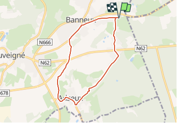
12,7 km | 16,8 km-effort
3h 31min
![](https://static1.geolcdn.com/siteimages/upload/files/16400158638029165_repeat_loop_refresh_sync_direction_icon.png)
Ja
![Tocht Stappen Trooz - RB-Lg-03 - Entre Vesdre et Hoëgne - Photo](https://media.geolcdn.com/t/375/260/ext.jpg?maxdim=2&url=https%3A%2F%2Fservices.sitytrail.com%2FGeolivesWS%2FDownloadMedia.ashx%3FTrailID%3D179559%26Media%3Dcef2de81-7d4f-4fcd-9e9d-f315370fe61f.jpg)
![Stappen Stappen](https://static1.geolcdn.com/sitytour/trail-icons/101.png)
RB-Lg-03 - Entre Vesdre et Hoëgne
Stappen
Medium
(12)
Trooz,
Wallonië,
Luik,
Belgium
![](/images/other/stat-length.png)
22 km | 29 km-effort
6h 9min
![](https://static1.geolcdn.com/siteimages/upload/files/16400158638029165_repeat_loop_refresh_sync_direction_icon.png)
Ja
![Tocht Stappen Sprimont - Banneux - Rouge Thier - Adzeux - Photo](https://media.geolcdn.com/t/375/260/0f185ab2-d29a-4b49-b676-7a8415068951.jpg&format=jpg&maxdim=2)
![Stappen Stappen](https://static1.geolcdn.com/sitytour/trail-icons/101.png)
Banneux - Rouge Thier - Adzeux
Stappen
Gemakkelijk
(4)
Sprimont,
Wallonië,
Luik,
Belgium
![](/images/other/stat-length.png)
9,1 km | 11,3 km-effort
2h 34min
![](https://static1.geolcdn.com/siteimages/upload/files/16400158638029165_repeat_loop_refresh_sync_direction_icon.png)
Ja
![Tocht Stappen Trooz - 2022-02-03_17h57m35_BaladedeFraipont - Photo](https://media.geolcdn.com/t/375/260/a22be754-a7d6-4ac7-b88b-6e30a6735908.jpg&format=jpg&maxdim=2)
![Stappen Stappen](https://static1.geolcdn.com/sitytour/trail-icons/101.png)
2022-02-03_17h57m35_BaladedeFraipont
Stappen
Medium
(1)
Trooz,
Wallonië,
Luik,
Belgium
![](/images/other/stat-length.png)
12,3 km | 17,3 km-effort
3h 55min
![](https://static1.geolcdn.com/siteimages/upload/files/16400158638029165_repeat_loop_refresh_sync_direction_icon.png)
Ja
![Tocht Stappen Olne - 2021-03-10_16h10m11_1409 - Photo](https://media.geolcdn.com/t/375/260/8c16a020-3972-4fd4-95a4-e68b814bf4ee.jpg&format=jpg&maxdim=2)
![Stappen Stappen](https://static1.geolcdn.com/sitytour/trail-icons/101.png)
2021-03-10_16h10m11_1409
Stappen
Medium
(3)
Olne,
Wallonië,
Luik,
Belgium
![](/images/other/stat-length.png)
11,7 km | 16,1 km-effort
3h 39min
![](https://static1.geolcdn.com/siteimages/upload/files/16400158638029165_repeat_loop_refresh_sync_direction_icon.png)
Ja
![Tocht Stappen Theux - Theux Natura 2000 château Franchimont - Photo](https://media.geolcdn.com/t/375/260/c750767f-f208-4264-8684-0a202377691f.jpg&format=jpg&maxdim=2)
![Stappen Stappen](https://static1.geolcdn.com/sitytour/trail-icons/101.png)
Theux Natura 2000 château Franchimont
Stappen
Medium
(2)
Theux,
Wallonië,
Luik,
Belgium
![](/images/other/stat-length.png)
13,1 km | 17,3 km-effort
3h 0min
![](https://static1.geolcdn.com/siteimages/upload/files/16400158638029165_repeat_loop_refresh_sync_direction_icon.png)
Ja
![Tocht Trail Theux - Extratrail - Theux (blauw) 18 km - Photo](https://media.geolcdn.com/t/375/260/0911e17e-920d-442e-8495-16fc909f2c4f.jpg&format=jpg&maxdim=2)
![Trail Trail](https://static1.geolcdn.com/sitytour/trail-icons/104.png)
Extratrail - Theux (blauw) 18 km
Trail
Medium
(3)
Theux,
Wallonië,
Luik,
Belgium
![](/images/other/stat-length.png)
18,3 km | 25 km-effort
Onbekend
![](https://static1.geolcdn.com/siteimages/upload/files/16400158638029165_repeat_loop_refresh_sync_direction_icon.png)
Ja
![Tocht Stappen Sprimont - banneux . adzeux . grand pierreux . banneux / marche adeps 10 km - Photo](https://media.geolcdn.com/t/375/260/ea0ad600-3155-4a55-9c9f-23c4e38fbcee.jpg&format=jpg&maxdim=2)
![Stappen Stappen](https://static1.geolcdn.com/sitytour/trail-icons/101.png)
banneux . adzeux . grand pierreux . banneux / marche adeps 10 km
Stappen
Gemakkelijk
(1)
Sprimont,
Wallonië,
Luik,
Belgium
![](/images/other/stat-length.png)
8,6 km | 10,5 km-effort
2h 6min
![](https://static1.geolcdn.com/siteimages/upload/files/16400158638029165_repeat_loop_refresh_sync_direction_icon.png)
Ja
![Tocht Stappen Sprimont - les forges . fraipont . andoumont . les forges - Photo](https://media.geolcdn.com/t/375/260/7774fab4-c702-474d-9e3e-f53317a12b64.jpg&format=jpg&maxdim=2)
![Stappen Stappen](https://static1.geolcdn.com/sitytour/trail-icons/101.png)
les forges . fraipont . andoumont . les forges
Stappen
Medium
(3)
Sprimont,
Wallonië,
Luik,
Belgium
![](/images/other/stat-length.png)
11,3 km | 15,5 km-effort
3h 7min
![](https://static1.geolcdn.com/siteimages/upload/files/16400158638029165_repeat_loop_refresh_sync_direction_icon.png)
Ja
Un parcours varié, bois, ruisseaux, campagne. A combiner avec la visite fu Sanctuaire de Banneux Notre-Dame. Fait avec Luna 🐕 ➡️ Balade n°1, balisage rectangle rouge.