![](/images/other/stat-length.png)
![Tocht Te voet Pétange - Auto-Pédestre Rodange - Photo](https://media.geolcdn.com/t/1900/400/ext.pjpeg?maxdim=2&url=https%3A%2F%2Fstatic1.geolcdn.com%2Fsiteimages%2Fupload%2Ffiles%2F1545311037marcheuse_200dpi.jpg)
Auto-Pédestre Rodange
SityTrail - itinéraires balisés pédestres
Tous les sentiers balisés d’Europe GUIDE+
![Lengte](/images/other/stat-length.png)
Lengte
8,6 km
![Max. hoogte](https://static1.geolcdn.com/siteimages/upload/files/1508320355ic_sort_altitude_max_24dp.png)
Max. hoogte
423 m
![Positief hoogteverschil](https://static1.geolcdn.com/siteimages/upload/files/1508320355ic_sort_den_pos_24dp.png)
Positief hoogteverschil
245 m
![Km-Effort](/images/other/stat-length.png)
Km-Effort
11,9 km
![Min. hoogte](https://static1.geolcdn.com/siteimages/upload/files/1508320355ic_sort_altitude_min_24dp.png)
Min. hoogte
278 m
![Negatief hoogteverschil](https://static1.geolcdn.com/siteimages/upload/files/1508320355ic_sort_den_neg_24dp.png)
Negatief hoogteverschil
240 m
![Boucle](https://static1.geolcdn.com/siteimages/upload/files/16400158638029165_repeat_loop_refresh_sync_direction_icon.png)
Boucle
Ja
Markering
Datum van aanmaak :
2022-02-09 18:51:52.96
Laatste wijziging :
2022-02-09 18:51:52.96
![Te voet](https://static1.geolcdn.com/sitytour/trail-icons/100.png)
2h41
Moeilijkheid : Gemakkelijk
![Scan deze QR-code om de tocht te openen in de SityTrail-applicatie](https://capi.geolives.com/qq0zvz2zws4bq2lad0pu/sitytour/trails/3084809/qr.png?size=200)
Gratisgps-wandelapplicatie
Over ons
Tocht Te voet van 8,6 km beschikbaar op Onbekend, Canton Esch-sur-Alzette, Pétange. Deze tocht wordt voorgesteld door SityTrail - itinéraires balisés pédestres.
Beschrijving
Trail created by Ministère de l´Économie.
Website: https://map.geoportail.lu/theme/tourisme?fid=176_4591701
Plaatsbepaling
Land:
Luxembourg
Regio :
Onbekend
Departement/Provincie :
Canton Esch-sur-Alzette
Gemeente :
Pétange
Locatie:
Rodange
Vertrek:(Dec)
Vertrek:(UTM)
705557 ; 5491950 (31U) N.
Opmerkingen
Wandeltochten in de omgeving
![Tocht Te voet Aubange - BE-AU 01 - Photo](https://media.geolcdn.com/t/375/260/7f7289b5-d5ab-4003-b78e-f5dd73f8883f.jpeg&format=jpg&maxdim=2)
![Te voet Te voet](https://static1.geolcdn.com/sitytour/trail-icons/100.png)
BE-AU 01
Te voet
Gemakkelijk
Aubange,
Wallonië,
Luxemburg,
Belgium
![](/images/other/stat-length.png)
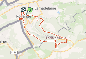
12,2 km | 14,9 km-effort
3h 22min
![](https://static1.geolcdn.com/siteimages/upload/files/16400158638029165_repeat_loop_refresh_sync_direction_icon.png)
Ja
![Tocht Te voet Pétange - Auto-Pédestre Pétange - Photo](https://media.geolcdn.com/t/375/260/3bda8901-8a45-455f-a0d9-28619ac75e15.jpeg&format=jpg&maxdim=2)
![Te voet Te voet](https://static1.geolcdn.com/sitytour/trail-icons/100.png)
Auto-Pédestre Pétange
Te voet
Gemakkelijk
Pétange,
Onbekend,
Canton Esch-sur-Alzette,
Luxembourg
![](/images/other/stat-length.png)
8,3 km | 10,4 km-effort
2h 21min
![](https://static1.geolcdn.com/siteimages/upload/files/16400158638029165_repeat_loop_refresh_sync_direction_icon.png)
Ja
![Tocht Te voet Pétange - Auto-Pédestre Lamadelaine - Photo](https://media.geolcdn.com/t/375/260/b8abde83-d7ee-4d08-8b56-7c6d44fc17fc.jpeg&format=jpg&maxdim=2)
![Te voet Te voet](https://static1.geolcdn.com/sitytour/trail-icons/100.png)
Auto-Pédestre Lamadelaine
Te voet
Gemakkelijk
Pétange,
Onbekend,
Canton Esch-sur-Alzette,
Luxembourg
![](/images/other/stat-length.png)
10,8 km | 13,4 km-effort
3h 2min
![](https://static1.geolcdn.com/siteimages/upload/files/16400158638029165_repeat_loop_refresh_sync_direction_icon.png)
Ja
![Tocht Te voet Käerjeng - Sentier Naturfrenn Käerjéng - Photo](https://media.geolcdn.com/t/375/260/60dcdf91-6252-4ac8-b795-309bfee6f33c.jpeg&format=jpg&maxdim=2)
![Te voet Te voet](https://static1.geolcdn.com/sitytour/trail-icons/100.png)
Sentier Naturfrenn Käerjéng
Te voet
Gemakkelijk
Käerjeng,
Onbekend,
Canton Capellen,
Luxembourg
![](/images/other/stat-length.png)
8,5 km | 10,4 km-effort
2h 22min
![](https://static1.geolcdn.com/siteimages/upload/files/16400158638029165_repeat_loop_refresh_sync_direction_icon.png)
Ja
![Tocht Te voet Käerjeng - Auto-Pédestre Bascharage - Photo](https://media.geolcdn.com/t/375/260/f1279973-8e1f-4680-90f5-548cd507bf83.jpeg&format=jpg&maxdim=2)
![Te voet Te voet](https://static1.geolcdn.com/sitytour/trail-icons/100.png)
Auto-Pédestre Bascharage
Te voet
Gemakkelijk
Käerjeng,
Onbekend,
Canton Capellen,
Luxembourg
![](/images/other/stat-length.png)
9 km | 10,6 km-effort
2h 24min
![](https://static1.geolcdn.com/siteimages/upload/files/16400158638029165_repeat_loop_refresh_sync_direction_icon.png)
Ja
![Tocht Te voet Aubange - Het mooie bos - Photo](https://media.geolcdn.com/t/375/260/004d9deb-44d3-48df-b1f8-dbcc850899c2.jpeg&format=jpg&maxdim=2)
![Te voet Te voet](https://static1.geolcdn.com/sitytour/trail-icons/100.png)
Het mooie bos
Te voet
Gemakkelijk
Aubange,
Wallonië,
Luxemburg,
Belgium
![](/images/other/stat-length.png)
8,5 km | 11,7 km-effort
2h 39min
![](https://static1.geolcdn.com/siteimages/upload/files/16400158638029165_repeat_loop_refresh_sync_direction_icon.png)
Ja
![Tocht Te voet Haucourt-Moulaine - Sentier du Beau Chêne - Photo](https://media.geolcdn.com/t/375/260/f060c4d5-b3a7-4872-84e5-b1f11835f082.jpeg&format=jpg&maxdim=2)
![Te voet Te voet](https://static1.geolcdn.com/sitytour/trail-icons/100.png)
Sentier du Beau Chêne
Te voet
Gemakkelijk
Haucourt-Moulaine,
Grand Est,
Meurthe-et-Moselle,
France
![](/images/other/stat-length.png)
10,8 km | 13,7 km-effort
3h 6min
![](https://static1.geolcdn.com/siteimages/upload/files/16400158638029165_repeat_loop_refresh_sync_direction_icon.png)
Ja
![Tocht Te voet Differdange - Sentier du Temps Perdu - Photo](https://media.geolcdn.com/t/375/260/f2ec4c4a-e3b0-42a8-a4b9-f770a42da903.jpeg&format=jpg&maxdim=2)
![Te voet Te voet](https://static1.geolcdn.com/sitytour/trail-icons/100.png)
Sentier du Temps Perdu
Te voet
Gemakkelijk
Differdange,
Onbekend,
Canton Esch-sur-Alzette,
Luxembourg
![](/images/other/stat-length.png)
6,6 km | 9,1 km-effort
2h 4min
![](https://static1.geolcdn.com/siteimages/upload/files/16400158638029165_repeat_loop_refresh_sync_direction_icon.png)
Ja
![Tocht Te voet Käerjeng - Auto-Pédestre Clemency 2 - Photo](https://media.geolcdn.com/t/375/260/6e6d7a4f-b83f-4d40-a520-6650674faa3f.jpeg&format=jpg&maxdim=2)
![Te voet Te voet](https://static1.geolcdn.com/sitytour/trail-icons/100.png)
Auto-Pédestre Clemency 2
Te voet
Gemakkelijk
Käerjeng,
Onbekend,
Canton Capellen,
Luxembourg
![](/images/other/stat-length.png)
8,4 km | 10 km-effort
2h 16min
![](https://static1.geolcdn.com/siteimages/upload/files/16400158638029165_repeat_loop_refresh_sync_direction_icon.png)
Ja