![](/images/other/stat-length.png)
![Tocht Te voet Maasmechelen - Station As Groene rechthoek - Photo](https://media.geolcdn.com/t/1900/400/6c3d6be9-86c4-472e-82c2-64c07d2c49aa.jpeg&format=pjpeg&maxdim=2)
Station As Groene rechthoek
SityTrail - itinéraires balisés pédestres
Tous les sentiers balisés d’Europe GUIDE+
![Lengte](/images/other/stat-length.png)
Lengte
3,3 km
![Max. hoogte](https://static1.geolcdn.com/siteimages/upload/files/1508320355ic_sort_altitude_max_24dp.png)
Max. hoogte
100 m
![Positief hoogteverschil](https://static1.geolcdn.com/siteimages/upload/files/1508320355ic_sort_den_pos_24dp.png)
Positief hoogteverschil
37 m
![Km-Effort](/images/other/stat-length.png)
Km-Effort
3,8 km
![Min. hoogte](https://static1.geolcdn.com/siteimages/upload/files/1508320355ic_sort_altitude_min_24dp.png)
Min. hoogte
77 m
![Negatief hoogteverschil](https://static1.geolcdn.com/siteimages/upload/files/1508320355ic_sort_den_neg_24dp.png)
Negatief hoogteverschil
37 m
![Boucle](https://static1.geolcdn.com/siteimages/upload/files/16400158638029165_repeat_loop_refresh_sync_direction_icon.png)
Boucle
Ja
Markering
Datum van aanmaak :
2022-02-09 18:47:30.335
Laatste wijziging :
2022-02-09 18:47:30.335
![Te voet](https://static1.geolcdn.com/sitytour/trail-icons/100.png)
51m
Moeilijkheid : Gemakkelijk
![Scan deze QR-code om de tocht te openen in de SityTrail-applicatie](https://capi.geolives.com/qq0zvz2zws4bq2lad0pu/sitytour/trails/3084746/qr.png?size=200)
Gratisgps-wandelapplicatie
Over ons
Tocht Te voet van 3,3 km beschikbaar op Vlaanderen, Limburg, Maasmechelen. Deze tocht wordt voorgesteld door SityTrail - itinéraires balisés pédestres.
Beschrijving
Trail created by Regionaal Landschap Kempen en Maasland.
Symbol: rectangle
Plaatsbepaling
Land:
Belgium
Regio :
Vlaanderen
Departement/Provincie :
Limburg
Gemeente :
Maasmechelen
Locatie:
Mechelen-aan-de-Maas
Vertrek:(Dec)
Vertrek:(UTM)
682672 ; 5653678 (31U) N.
Opmerkingen
Wandeltochten in de omgeving
![Tocht Stappen Maasmechelen - Mechelse Heide - Photo](https://media.geolcdn.com/t/375/260/501f02e9-8086-4be8-98c9-f01120ddee06.jpg&format=jpg&maxdim=2)
![Stappen Stappen](https://static1.geolcdn.com/sitytour/trail-icons/101.png)
Mechelse Heide
Stappen
Gemakkelijk
(2)
Maasmechelen,
Vlaanderen,
Limburg,
Belgium
![](/images/other/stat-length.png)
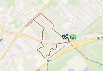
14,2 km | 16,2 km-effort
3h 41min
![](https://static1.geolcdn.com/siteimages/upload/files/16400158638029165_repeat_loop_refresh_sync_direction_icon.png)
Ja
![Tocht Te voet As - Mechelse Heide Noord - Photo](https://media.geolcdn.com/t/375/260/6c3d6be9-86c4-472e-82c2-64c07d2c49aa.jpeg&format=jpg&maxdim=2)
![Te voet Te voet](https://static1.geolcdn.com/sitytour/trail-icons/100.png)
Mechelse Heide Noord
Te voet
Gemakkelijk
As,
Vlaanderen,
Limburg,
Belgium
![](/images/other/stat-length.png)
4,3 km | 4,8 km-effort
1h 5min
![](https://static1.geolcdn.com/siteimages/upload/files/16400158638029165_repeat_loop_refresh_sync_direction_icon.png)
Neen
![Tocht Te voet As - Heiderbos blauwe ruit - Photo](https://media.geolcdn.com/t/375/260/e65c145e-dca4-4d58-ae17-fc8ca78c84c8.jpeg&format=jpg&maxdim=2)
![Te voet Te voet](https://static1.geolcdn.com/sitytour/trail-icons/100.png)
Heiderbos blauwe ruit
Te voet
Gemakkelijk
As,
Vlaanderen,
Limburg,
Belgium
![](/images/other/stat-length.png)
7,7 km | 8,5 km-effort
1h 56min
![](https://static1.geolcdn.com/siteimages/upload/files/16400158638029165_repeat_loop_refresh_sync_direction_icon.png)
Ja
![Tocht Te voet Genk - Thorpark Groene rechthoek - Photo](https://media.geolcdn.com/t/375/260/5d7a6518-21eb-43eb-96c3-b85d7a924753.jpeg&format=jpg&maxdim=2)
![Te voet Te voet](https://static1.geolcdn.com/sitytour/trail-icons/100.png)
Thorpark Groene rechthoek
Te voet
Gemakkelijk
Genk,
Vlaanderen,
Limburg,
Belgium
![](/images/other/stat-length.png)
4,1 km | 4,4 km-effort
1h 0min
![](https://static1.geolcdn.com/siteimages/upload/files/16400158638029165_repeat_loop_refresh_sync_direction_icon.png)
Ja
![Tocht Te voet Genk - Thorpark - De Kolonie Rode driehoek - Photo](https://media.geolcdn.com/t/375/260/1c715178-bd32-42a8-8c79-dfbf5aac80a5.jpeg&format=jpg&maxdim=2)
![Te voet Te voet](https://static1.geolcdn.com/sitytour/trail-icons/100.png)
Thorpark - De Kolonie Rode driehoek
Te voet
Gemakkelijk
Genk,
Vlaanderen,
Limburg,
Belgium
![](/images/other/stat-length.png)
12,5 km | 14,1 km-effort
3h 12min
![](https://static1.geolcdn.com/siteimages/upload/files/16400158638029165_repeat_loop_refresh_sync_direction_icon.png)
Ja
![Tocht Te voet Genk - Thorpark Blauwe ruit - Photo](https://media.geolcdn.com/t/375/260/5d7a6518-21eb-43eb-96c3-b85d7a924753.jpeg&format=jpg&maxdim=2)
![Te voet Te voet](https://static1.geolcdn.com/sitytour/trail-icons/100.png)
Thorpark Blauwe ruit
Te voet
Gemakkelijk
Genk,
Vlaanderen,
Limburg,
Belgium
![](/images/other/stat-length.png)
7,6 km | 8,7 km-effort
1h 58min
![](https://static1.geolcdn.com/siteimages/upload/files/16400158638029165_repeat_loop_refresh_sync_direction_icon.png)
Ja
![Tocht Te voet Genk - Thorpark - Heiderbos Gele zeshoek - Photo](https://media.geolcdn.com/t/375/260/c6f79672-6cbb-4c88-882a-ca6add2e9582.jpeg&format=jpg&maxdim=2)
![Te voet Te voet](https://static1.geolcdn.com/sitytour/trail-icons/100.png)
Thorpark - Heiderbos Gele zeshoek
Te voet
Gemakkelijk
Genk,
Vlaanderen,
Limburg,
Belgium
![](/images/other/stat-length.png)
16,3 km | 18,5 km-effort
4h 12min
![](https://static1.geolcdn.com/siteimages/upload/files/16400158638029165_repeat_loop_refresh_sync_direction_icon.png)
Ja
![Tocht Te voet Genk - Thorpark Erfgoedroute - Photo](https://media.geolcdn.com/t/375/260/cb1f562b-a158-4abb-b585-f6a3e885b845.jpeg&format=jpg&maxdim=2)
![Te voet Te voet](https://static1.geolcdn.com/sitytour/trail-icons/100.png)
Thorpark Erfgoedroute
Te voet
Gemakkelijk
Genk,
Vlaanderen,
Limburg,
Belgium
![](/images/other/stat-length.png)
12 km | 13,4 km-effort
3h 2min
![](https://static1.geolcdn.com/siteimages/upload/files/16400158638029165_repeat_loop_refresh_sync_direction_icon.png)
Ja
![Tocht Te voet Dilsen-Stokkem - Connecterra Rode driehoek - Photo](https://media.geolcdn.com/t/375/260/5eb5c103-eb27-4a59-83d3-dfd2672ebb0c.jpeg&format=jpg&maxdim=2)
![Te voet Te voet](https://static1.geolcdn.com/sitytour/trail-icons/100.png)
Connecterra Rode driehoek
Te voet
Gemakkelijk
Dilsen-Stokkem,
Vlaanderen,
Limburg,
Belgium
![](/images/other/stat-length.png)
6,2 km | 7 km-effort
1h 35min
![](https://static1.geolcdn.com/siteimages/upload/files/16400158638029165_repeat_loop_refresh_sync_direction_icon.png)
Neen