![](/images/other/stat-length.png)
![Tocht Te voet Bertem - Ruwaalwandeling - Photo](https://media.geolcdn.com/t/1900/400/5c5824f2-e747-4bd0-9a87-55819990fde9.jpeg&format=pjpeg&maxdim=2)
Ruwaalwandeling
SityTrail - itinéraires balisés pédestres
Tous les sentiers balisés d’Europe GUIDE+
![Lengte](/images/other/stat-length.png)
Lengte
6,1 km
![Max. hoogte](https://static1.geolcdn.com/siteimages/upload/files/1508320355ic_sort_altitude_max_24dp.png)
Max. hoogte
78 m
![Positief hoogteverschil](https://static1.geolcdn.com/siteimages/upload/files/1508320355ic_sort_den_pos_24dp.png)
Positief hoogteverschil
78 m
![Km-Effort](/images/other/stat-length.png)
Km-Effort
7,1 km
![Min. hoogte](https://static1.geolcdn.com/siteimages/upload/files/1508320355ic_sort_altitude_min_24dp.png)
Min. hoogte
23 m
![Negatief hoogteverschil](https://static1.geolcdn.com/siteimages/upload/files/1508320355ic_sort_den_neg_24dp.png)
Negatief hoogteverschil
77 m
![Boucle](https://static1.geolcdn.com/siteimages/upload/files/16400158638029165_repeat_loop_refresh_sync_direction_icon.png)
Boucle
Ja
Markering
Datum van aanmaak :
2022-02-09 15:07:01.67
Laatste wijziging :
2022-02-09 17:53:28.691
![Te voet](https://static1.geolcdn.com/sitytour/trail-icons/100.png)
1h37
Moeilijkheid : Gemakkelijk
![Scan deze QR-code om de tocht te openen in de SityTrail-applicatie](https://capi.geolives.com/qq0zvz2zws4bq2lad0pu/sitytour/trails/3083285/qr.png?size=200)
Gratisgps-wandelapplicatie
Over ons
Tocht Te voet van 6,1 km beschikbaar op Vlaanderen, Vlaams-Brabant, Bertem. Deze tocht wordt voorgesteld door SityTrail - itinéraires balisés pédestres.
Beschrijving
Trail created by vzw Toerisme Vlaams-Brabant..
Symbol: Zeskantige plaatjes met rode tekst
Plaatsbepaling
Land:
Belgium
Regio :
Vlaanderen
Departement/Provincie :
Vlaams-Brabant
Gemeente :
Bertem
Locatie:
Korbeek-Dijle
Vertrek:(Dec)
Vertrek:(UTM)
614606 ; 5632886 (31U) N.
Opmerkingen
Wandeltochten in de omgeving
![Stappen Stappen](https://static1.geolcdn.com/sitytour/trail-icons/101.png)
#230710 - Neerijse, Dyle et Doode Bemde
Stappen
Medium
(1)
Huldenberg,
Vlaanderen,
Vlaams-Brabant,
Belgium
![](/images/other/stat-length.png)
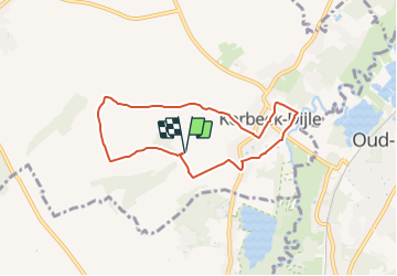
5,9 km | 6,7 km-effort
1h 30min
![](https://static1.geolcdn.com/siteimages/upload/files/16400158638029165_repeat_loop_refresh_sync_direction_icon.png)
Ja
![Tocht Stappen Huldenberg - Neerijse - Photo](https://media.geolcdn.com/t/375/260/b505182f-f472-49dd-a001-eca0e6e830b0.jpg&format=jpg&maxdim=2)
![Stappen Stappen](https://static1.geolcdn.com/sitytour/trail-icons/101.png)
Neerijse
Stappen
Moeilijk
(1)
Huldenberg,
Vlaanderen,
Vlaams-Brabant,
Belgium
![](/images/other/stat-length.png)
19,7 km | 23 km-effort
6h 7min
![](https://static1.geolcdn.com/siteimages/upload/files/16400158638029165_repeat_loop_refresh_sync_direction_icon.png)
Ja
![Stappen Stappen](https://static1.geolcdn.com/sitytour/trail-icons/101.png)
20220319 - Un jour à Leuven
Stappen
Gemakkelijk
Leuven,
Vlaanderen,
Vlaams-Brabant,
Belgium
![](/images/other/stat-length.png)
7,8 km | 8,6 km-effort
5h 49min
![](https://static1.geolcdn.com/siteimages/upload/files/16400158638029165_repeat_loop_refresh_sync_direction_icon.png)
Ja
![Tocht Stappen Huldenberg - petite rando autour du kinderveld - Photo](https://media.geolcdn.com/t/375/260/5401b562-0f0d-4a2d-86bd-a6a7eb30010d.jpg&format=jpg&maxdim=2)
![Stappen Stappen](https://static1.geolcdn.com/sitytour/trail-icons/101.png)
petite rando autour du kinderveld
Stappen
Heel gemakkelijk
Huldenberg,
Vlaanderen,
Vlaams-Brabant,
Belgium
![](/images/other/stat-length.png)
10,7 km | 12,5 km-effort
3h 5min
![](https://static1.geolcdn.com/siteimages/upload/files/16400158638029165_repeat_loop_refresh_sync_direction_icon.png)
Neen
![Tocht Mountainbike Bertem - MTB 2017_Bertem-Oud-Heverlee-Leefdaal 30 km - Photo](https://media.geolcdn.com/t/375/260/ext.jpg?maxdim=2&url=https%3A%2F%2Fstatic1.geolcdn.com%2Fsiteimages%2Fupload%2Ffiles%2F1524743154velo.jpg)
![Mountainbike Mountainbike](https://static1.geolcdn.com/sitytour/trail-icons/202.png)
MTB 2017_Bertem-Oud-Heverlee-Leefdaal 30 km
Mountainbike
Medium
(1)
Bertem,
Vlaanderen,
Vlaams-Brabant,
Belgium
![](/images/other/stat-length.png)
30 km | 36 km-effort
2h 19min
![](https://static1.geolcdn.com/siteimages/upload/files/16400158638029165_repeat_loop_refresh_sync_direction_icon.png)
Ja
![Tocht Mountainbike Bertem - MTB_bertem-sterrebeek 28 km - Photo](https://media.geolcdn.com/t/375/260/ext.jpg?maxdim=2&url=https%3A%2F%2Fstatic1.geolcdn.com%2Fsiteimages%2Fupload%2Ffiles%2F1524743154velo.jpg)
![Mountainbike Mountainbike](https://static1.geolcdn.com/sitytour/trail-icons/202.png)
MTB_bertem-sterrebeek 28 km
Mountainbike
Medium
(1)
Bertem,
Vlaanderen,
Vlaams-Brabant,
Belgium
![](/images/other/stat-length.png)
28 km | 34 km-effort
2h 19min
![](https://static1.geolcdn.com/siteimages/upload/files/16400158638029165_repeat_loop_refresh_sync_direction_icon.png)
Ja
![Tocht Noords wandelen Oud-Heverlee - 2015-05-07 MNJ Doode Bemde - Photo](https://media.geolcdn.com/t/375/260/ext.jpg?maxdim=2&url=https%3A%2F%2Fstatic1.geolcdn.com%2Fsiteimages%2Fupload%2Ffiles%2F1545311037marcheuse_200dpi.jpg)
![Noords wandelen Noords wandelen](https://static1.geolcdn.com/sitytour/trail-icons/102.png)
2015-05-07 MNJ Doode Bemde
Noords wandelen
Gemakkelijk
(1)
Oud-Heverlee,
Vlaanderen,
Vlaams-Brabant,
Belgium
![](/images/other/stat-length.png)
9,5 km | 10,9 km-effort
2h 50min
![](https://static1.geolcdn.com/siteimages/upload/files/16400158638029165_repeat_loop_refresh_sync_direction_icon.png)
Ja
![Tocht Stappen Bertem - leefdal - Photo](https://media.geolcdn.com/t/375/260/ext.jpg?maxdim=2&url=https%3A%2F%2Fstatic1.geolcdn.com%2Fsiteimages%2Fupload%2Ffiles%2F1553511878bg_sport_marche.png)
![Stappen Stappen](https://static1.geolcdn.com/sitytour/trail-icons/101.png)
leefdal
Stappen
Heel gemakkelijk
(1)
Bertem,
Vlaanderen,
Vlaams-Brabant,
Belgium
![](/images/other/stat-length.png)
9,7 km | 11,2 km-effort
2h 26min
![](https://static1.geolcdn.com/siteimages/upload/files/16400158638029165_repeat_loop_refresh_sync_direction_icon.png)
Ja
![Tocht Elektrische fiets Leuven - 2024-11-01_12h39m39_Foret de Meerdaal - Photo](https://media.geolcdn.com/t/375/260/ext.jpg?maxdim=2&url=https%3A%2F%2Fstatic1.geolcdn.com%2Fsiteimages%2Fupload%2Ffiles%2F1524743154velo.jpg)
![Elektrische fiets Elektrische fiets](https://static1.geolcdn.com/sitytour/trail-icons/205.png)
2024-11-01_12h39m39_Foret de Meerdaal
Elektrische fiets
Heel gemakkelijk
(1)
Leuven,
Vlaanderen,
Vlaams-Brabant,
Belgium
![](/images/other/stat-length.png)
23 km | 27 km-effort
Onbekend
![](https://static1.geolcdn.com/siteimages/upload/files/16400158638029165_repeat_loop_refresh_sync_direction_icon.png)
Ja