![](/images/other/stat-length.png)
![Tocht Te voet Anthisnes - Rondom Sarts - Photo](https://media.geolcdn.com/t/1900/400/ext.pjpeg?maxdim=2&url=https%3A%2F%2Fpivotmedia.tourismewallonie.be%2FANX-0W-000PCU%2FANX-0W-000PCU.jpg)
Rondom Sarts
Commissariat général au Tourisme
Randonnées du CGT GUIDE+
![Lengte](/images/other/stat-length.png)
Lengte
10,4 km
![Max. hoogte](https://static1.geolcdn.com/siteimages/upload/files/1508320355ic_sort_altitude_max_24dp.png)
Max. hoogte
283 m
![Positief hoogteverschil](https://static1.geolcdn.com/siteimages/upload/files/1508320355ic_sort_den_pos_24dp.png)
Positief hoogteverschil
188 m
![Km-Effort](/images/other/stat-length.png)
Km-Effort
12,9 km
![Min. hoogte](https://static1.geolcdn.com/siteimages/upload/files/1508320355ic_sort_altitude_min_24dp.png)
Min. hoogte
181 m
![Negatief hoogteverschil](https://static1.geolcdn.com/siteimages/upload/files/1508320355ic_sort_den_neg_24dp.png)
Negatief hoogteverschil
187 m
![Boucle](https://static1.geolcdn.com/siteimages/upload/files/16400158638029165_repeat_loop_refresh_sync_direction_icon.png)
Boucle
Ja
Datum van aanmaak :
2022-02-08 11:37:45.976
Laatste wijziging :
2022-02-21 10:19:16.324
![Te voet](https://static1.geolcdn.com/sitytour/trail-icons/100.png)
2h56
Moeilijkheid : Gemakkelijk
![Scan deze QR-code om de tocht te openen in de SityTrail-applicatie](https://capi.geolives.com/qq0zvz2zws4bq2lad0pu/sitytour/trails/3081488/qr.png?size=200)
Gratisgps-wandelapplicatie
Over ons
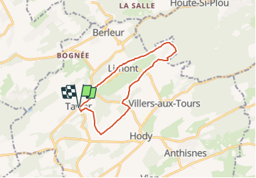
Tocht Te voet van 10,4 km beschikbaar op Wallonië, Luik, Anthisnes. Deze tocht wordt voorgesteld door Commissariat général au Tourisme.
Beschrijving
Trail created by Ourthe Vesdre Amblève.
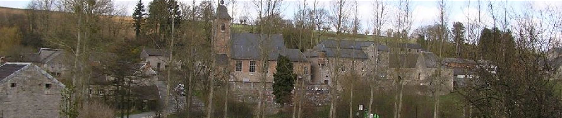
Via het oude spoorlijntje van Tultay komt men bij Limont (prachtig architecturaal geheel). Via Lagrange en Hestreux terug naar Tavier.
Plaatsbepaling
Land:
Belgium
Regio :
Wallonië
Departement/Provincie :
Luik
Gemeente :
Anthisnes
Locatie:
Unknown
Vertrek:(Dec)
Vertrek:(UTM)
675261 ; 5596644 (31U) N.
Opmerkingen
Wandeltochten in de omgeving
![Tocht Stappen Anthisnes - RB-Lg-18_Tavier - Photo](https://media.geolcdn.com/t/375/260/ext.jpg?maxdim=2&url=https%3A%2F%2Fservices.sitytrail.com%2FGeolivesWS%2FDownloadMedia.ashx%3FTrailID%3D400569%26Media%3D8137f08d-271c-4dcb-b2bd-96adf6706999.jpg)
![Stappen Stappen](https://static1.geolcdn.com/sitytour/trail-icons/101.png)
RB-Lg-18_Tavier
Stappen
Zeer moeilijk
(10)
Anthisnes,
Wallonië,
Luik,
Belgium
![](/images/other/stat-length.png)
22 km | 28 km-effort
6h 19min
![](https://static1.geolcdn.com/siteimages/upload/files/16400158638029165_repeat_loop_refresh_sync_direction_icon.png)
Ja
![Tocht Stappen Neupré - Neupré - liaisons inter-hameaux et -villages - Photo](https://media.geolcdn.com/t/375/260/ext.jpg?maxdim=2&url=https%3A%2F%2Fservices.sitytrail.com%2FGeolivesWS%2FDownloadMedia.ashx%3FTrailID%3D347446%26Media%3Dfix__20140903123425.jpg)
![Stappen Stappen](https://static1.geolcdn.com/sitytour/trail-icons/101.png)
Neupré - liaisons inter-hameaux et -villages
Stappen
Medium
(13)
Neupré,
Wallonië,
Luik,
Belgium
![](/images/other/stat-length.png)
10,8 km | 14,1 km-effort
2h 59min
![](https://static1.geolcdn.com/siteimages/upload/files/16400158638029165_repeat_loop_refresh_sync_direction_icon.png)
Ja
![Tocht Stappen Neupré - Neupré - balade de Rotheux - Photo](https://media.geolcdn.com/t/375/260/ext.jpg?maxdim=2&url=https%3A%2F%2Fservices.sitytrail.com%2FGeolivesWS%2FDownloadMedia.ashx%3FTrailID%3D347399%26Media%3D32c01f91-c180-4d53-8d7d-a74522876cd8.JPG)
![Stappen Stappen](https://static1.geolcdn.com/sitytour/trail-icons/101.png)
Neupré - balade de Rotheux
Stappen
Medium
(11)
Neupré,
Wallonië,
Luik,
Belgium
![](/images/other/stat-length.png)
8,7 km | 11,1 km-effort
2h 21min
![](https://static1.geolcdn.com/siteimages/upload/files/16400158638029165_repeat_loop_refresh_sync_direction_icon.png)
Ja
![Tocht Stappen Neupré - Neupré - Balade du Chemin des morts - Photo](https://media.geolcdn.com/t/375/260/ext.jpg?maxdim=2&url=https%3A%2F%2Fstatic1.geolcdn.com%2Fsiteimages%2Fupload%2Ffiles%2F1553511878bg_sport_marche.png)
![Stappen Stappen](https://static1.geolcdn.com/sitytour/trail-icons/101.png)
Neupré - Balade du Chemin des morts
Stappen
Medium
(15)
Neupré,
Wallonië,
Luik,
Belgium
![](/images/other/stat-length.png)
5,1 km | 7,4 km-effort
1h 33min
![](https://static1.geolcdn.com/siteimages/upload/files/16400158638029165_repeat_loop_refresh_sync_direction_icon.png)
Ja
![Tocht Stappen Anthisnes - Anthines - AS03 - Boucle de Tolumont - Losange Bleu - Photo](https://media.geolcdn.com/t/375/260/a3413dfd-3361-4d9b-b91d-7efec18943a3.jpg&format=jpg&maxdim=2)
![Stappen Stappen](https://static1.geolcdn.com/sitytour/trail-icons/101.png)
Anthines - AS03 - Boucle de Tolumont - Losange Bleu
Stappen
Medium
(2)
Anthisnes,
Wallonië,
Luik,
Belgium
![](/images/other/stat-length.png)
13,9 km | 18,2 km-effort
2h 56min
![](https://static1.geolcdn.com/siteimages/upload/files/16400158638029165_repeat_loop_refresh_sync_direction_icon.png)
Ja
![Tocht Te voet Anthisnes - AS03 Boucle de Tolumont - Photo](https://media.geolcdn.com/t/375/260/bb3be3cf-eddc-4622-8273-ff9944f2671c.jpg&format=jpg&maxdim=2)
![Te voet Te voet](https://static1.geolcdn.com/sitytour/trail-icons/100.png)
AS03 Boucle de Tolumont
Te voet
Medium
(1)
Anthisnes,
Wallonië,
Luik,
Belgium
![](/images/other/stat-length.png)
13,4 km | 17,6 km-effort
3h 20min
![](https://static1.geolcdn.com/siteimages/upload/files/16400158638029165_repeat_loop_refresh_sync_direction_icon.png)
Ja
![Tocht Stappen Anthisnes - Hody . drive d Anthisnes . carrière . Targnon . Hestreux . Fond de Sart . Hody - Photo](https://media.geolcdn.com/t/375/260/ac4de494-7be1-46d6-92d3-c5a298377ce3.jpg&format=jpg&maxdim=2)
![Stappen Stappen](https://static1.geolcdn.com/sitytour/trail-icons/101.png)
Hody . drive d Anthisnes . carrière . Targnon . Hestreux . Fond de Sart . Hody
Stappen
Gemakkelijk
(1)
Anthisnes,
Wallonië,
Luik,
Belgium
![](/images/other/stat-length.png)
11,5 km | 14,2 km-effort
3h 6min
![](https://static1.geolcdn.com/siteimages/upload/files/16400158638029165_repeat_loop_refresh_sync_direction_icon.png)
Ja
![Tocht Stappen Esneux - à travers les bois d Anthines et d Esneux - Photo](https://media.geolcdn.com/t/375/260/8982e1fa-30a1-4d67-9442-26344ceef648.jpg&format=jpg&maxdim=2)
![Stappen Stappen](https://static1.geolcdn.com/sitytour/trail-icons/101.png)
à travers les bois d Anthines et d Esneux
Stappen
Heel gemakkelijk
(2)
Esneux,
Wallonië,
Luik,
Belgium
![](/images/other/stat-length.png)
11 km | 15 km-effort
3h 1min
![](https://static1.geolcdn.com/siteimages/upload/files/16400158638029165_repeat_loop_refresh_sync_direction_icon.png)
Ja
![Tocht Mountainbike Anthisnes - première rando anthisne tavier - Photo](https://media.geolcdn.com/t/375/260/ext.jpg?maxdim=2&url=https%3A%2F%2Fservices.sitytrail.com%2FGeolivesWS%2FDownloadMedia.ashx%3FTrailID%3D826413%26Media%3Dfix__20170910110510.jpg)
![Mountainbike Mountainbike](https://static1.geolcdn.com/sitytour/trail-icons/202.png)
première rando anthisne tavier
Mountainbike
Medium
(1)
Anthisnes,
Wallonië,
Luik,
Belgium
![](/images/other/stat-length.png)
10,2 km | 13,4 km-effort
1h 8min
![](https://static1.geolcdn.com/siteimages/upload/files/16400158638029165_repeat_loop_refresh_sync_direction_icon.png)
Ja