![](/images/other/stat-length.png)
![Tocht Te voet Anthisnes - Rondom Tolumont - Photo](https://media.geolcdn.com/t/1900/400/ext.pjpeg?maxdim=2&url=https%3A%2F%2Fpivotmedia.tourismewallonie.be%2FANX-0W-000PBS%2FANX-0W-000PBS.jpg)
Rondom Tolumont
Commissariat général au Tourisme
Randonnées du CGT GUIDE+
![Lengte](/images/other/stat-length.png)
![Max. hoogte](https://static1.geolcdn.com/siteimages/upload/files/1508320355ic_sort_altitude_max_24dp.png)
![Positief hoogteverschil](https://static1.geolcdn.com/siteimages/upload/files/1508320355ic_sort_den_pos_24dp.png)
![Km-Effort](/images/other/stat-length.png)
![Min. hoogte](https://static1.geolcdn.com/siteimages/upload/files/1508320355ic_sort_altitude_min_24dp.png)
![Negatief hoogteverschil](https://static1.geolcdn.com/siteimages/upload/files/1508320355ic_sort_den_neg_24dp.png)
![Boucle](https://static1.geolcdn.com/siteimages/upload/files/16400158638029165_repeat_loop_refresh_sync_direction_icon.png)
![Te voet](https://static1.geolcdn.com/sitytour/trail-icons/100.png)
3h59
Moeilijkheid : Gemakkelijk
![Scan deze QR-code om de tocht te openen in de SityTrail-applicatie](https://capi.geolives.com/qq0zvz2zws4bq2lad0pu/sitytour/trails/3081485/qr.png?size=200)
Gratisgps-wandelapplicatie
Over ons
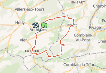
Tocht Te voet van 13,3 km beschikbaar op Wallonië, Luik, Anthisnes. Deze tocht wordt voorgesteld door Commissariat général au Tourisme.
Beschrijving
Trail created by Ourthe Vesdre Amblève.
De Boucle de Tolumont volgt in het begin dezelfde route als de Boucle de la Bégasse maar gaat ter hoogte van de kunstenaarsbank haar eigen weg, richting het dorpje Mont (Comblain). De lus van Tolumont loopt langs de boerderij van Raideux, en verder door de bossen van Ouhar, Vien en Tolumont. Daarna gaat u via de voormalige zandafgraving van Larbois (waar vroeger geel zand gewonnen werd) richting de Hoeve van Tolumont en de Drève (Laan) des Stepennes. Vervolgens daalt de wandeling langs de ‘chemin du facteur’ af tot in het dorpje La Rock, waar u de oude waterfontein kunnen bewonderen. Tot slot voert het pad « Sur Les Beurs » weer terug naar het kasteel van de Avouerie.
Plaatsbepaling
Opmerkingen
Wandeltochten in de omgeving
![Tocht Stappen Esneux - Esneux bois du mary - Photo](https://media.geolcdn.com/t/375/260/71c77441-f9b7-4220-bb0a-fbf9c3317653.jpg&format=jpg&maxdim=2)
![Stappen Stappen](https://static1.geolcdn.com/sitytour/trail-icons/101.png)
Stappen
![](/images/other/stat-length.png)
![](https://static1.geolcdn.com/siteimages/upload/files/16400158638029165_repeat_loop_refresh_sync_direction_icon.png)
![Tocht Stappen Anthisnes - RB-Lg-18_Tavier - Photo](https://media.geolcdn.com/t/375/260/ext.jpg?maxdim=2&url=https%3A%2F%2Fservices.sitytrail.com%2FGeolivesWS%2FDownloadMedia.ashx%3FTrailID%3D400569%26Media%3D8137f08d-271c-4dcb-b2bd-96adf6706999.jpg)
![Stappen Stappen](https://static1.geolcdn.com/sitytour/trail-icons/101.png)
Stappen
![](/images/other/stat-length.png)
![](https://static1.geolcdn.com/siteimages/upload/files/16400158638029165_repeat_loop_refresh_sync_direction_icon.png)
![Stappen Stappen](https://static1.geolcdn.com/sitytour/trail-icons/101.png)
Stappen
![](/images/other/stat-length.png)
![](https://static1.geolcdn.com/siteimages/upload/files/16400158638029165_repeat_loop_refresh_sync_direction_icon.png)
![Tocht Stappen Comblain-au-Pont - RF-Lg-04_Comblain-au-Pont_Grande-boucle - Photo](https://media.geolcdn.com/t/375/260/b6c1584e-1801-407f-b05d-19d8f1862ff5.jpg&format=jpg&maxdim=2)
![Stappen Stappen](https://static1.geolcdn.com/sitytour/trail-icons/101.png)
Stappen
![](/images/other/stat-length.png)
![](https://static1.geolcdn.com/siteimages/upload/files/16400158638029165_repeat_loop_refresh_sync_direction_icon.png)
![Tocht Stappen Comblain-au-Pont - 2021-06-30_15h22m22_Cirkwi-Autour_de_Comblain-au-Pont_-_Promenade_3___Four_à_chaux_-_Mont_-_Poulseur_-_Canal_de_l_Ourthe_-_Rivage - Photo](https://media.geolcdn.com/t/375/260/e3bd39c1-3623-4715-901d-7409f699ba3a.jpg&format=jpg&maxdim=2)
![Stappen Stappen](https://static1.geolcdn.com/sitytour/trail-icons/101.png)
Stappen
![](/images/other/stat-length.png)
![](https://static1.geolcdn.com/siteimages/upload/files/16400158638029165_repeat_loop_refresh_sync_direction_icon.png)
![Tocht Stappen Comblain-au-Pont - 2021-05-13_19h25m39_Cirkwi-Autour_de_Comblain-au-Pont_-_Promenade_10___Thier_Pirard_-_Hoyemont_-_Comblinay_-_Comblain-la-Tour_-_Comblain-au-Pont - Photo](https://media.geolcdn.com/t/375/260/978e853c-be9c-453e-b61f-b42dde075b4b.jpg&format=jpg&maxdim=2)
![Stappen Stappen](https://static1.geolcdn.com/sitytour/trail-icons/101.png)
Stappen
![](/images/other/stat-length.png)
![](https://static1.geolcdn.com/siteimages/upload/files/16400158638029165_repeat_loop_refresh_sync_direction_icon.png)
![Tocht Stappen Comblain-au-Pont - 2021-04-04_15h31m49_Cirkwi-Autour_de_Comblain-au-Pont_-_Promenade_9___Grotte_-_Raideux_-_Anthisnes_-_Les_Stepennes_-_Géromont - Photo](https://media.geolcdn.com/t/375/260/edfd852c-0012-45e6-9a23-c8c8cd48cf84.jpg&format=jpg&maxdim=2)
![Stappen Stappen](https://static1.geolcdn.com/sitytour/trail-icons/101.png)
Stappen
![](/images/other/stat-length.png)
![](https://static1.geolcdn.com/siteimages/upload/files/16400158638029165_repeat_loop_refresh_sync_direction_icon.png)
![Tocht Stappen Anthisnes - Anthines - AS03 - Boucle de Tolumont - Losange Bleu - Photo](https://media.geolcdn.com/t/375/260/a3413dfd-3361-4d9b-b91d-7efec18943a3.jpg&format=jpg&maxdim=2)
![Stappen Stappen](https://static1.geolcdn.com/sitytour/trail-icons/101.png)
Stappen
![](/images/other/stat-length.png)
![](https://static1.geolcdn.com/siteimages/upload/files/16400158638029165_repeat_loop_refresh_sync_direction_icon.png)
![Tocht Te voet Anthisnes - AS03 Boucle de Tolumont - Photo](https://media.geolcdn.com/t/375/260/bb3be3cf-eddc-4622-8273-ff9944f2671c.jpg&format=jpg&maxdim=2)
![Te voet Te voet](https://static1.geolcdn.com/sitytour/trail-icons/100.png)
Te voet
![](/images/other/stat-length.png)
![](https://static1.geolcdn.com/siteimages/upload/files/16400158638029165_repeat_loop_refresh_sync_direction_icon.png)