![](/images/other/stat-length.png)
![Tocht Paard Rumes - Ruiter- & menroute van Rumes - Doornik - Photo](https://media.geolcdn.com/t/1900/400/ext.pjpeg?maxdim=2&url=https%3A%2F%2Fpivotmedia.tourismewallonie.be%2FANX-02-000EIZ%2FANX-02-000EIZ.jpg)
Ruiter- & menroute van Rumes - Doornik
Commissariat général au Tourisme
Randonnées du CGT GUIDE+
![Lengte](/images/other/stat-length.png)
![Max. hoogte](https://static1.geolcdn.com/siteimages/upload/files/1508320355ic_sort_altitude_max_24dp.png)
![Positief hoogteverschil](https://static1.geolcdn.com/siteimages/upload/files/1508320355ic_sort_den_pos_24dp.png)
![Km-Effort](/images/other/stat-length.png)
![Min. hoogte](https://static1.geolcdn.com/siteimages/upload/files/1508320355ic_sort_altitude_min_24dp.png)
![Negatief hoogteverschil](https://static1.geolcdn.com/siteimages/upload/files/1508320355ic_sort_den_neg_24dp.png)
![Boucle](https://static1.geolcdn.com/siteimages/upload/files/16400158638029165_repeat_loop_refresh_sync_direction_icon.png)
![Paard](https://static1.geolcdn.com/sitytour/trail-icons/300.png)
--
Moeilijkheid : Onbekend
![Scan deze QR-code om de tocht te openen in de SityTrail-applicatie](https://capi.geolives.com/qq0zvz2zws4bq2lad0pu/sitytour/trails/3081414/qr.png?size=200)
Gratisgps-wandelapplicatie
Over ons
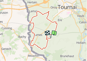
Tocht Paard van 30 km beschikbaar op Wallonië, Henegouwen, Rumes. Deze tocht wordt voorgesteld door Commissariat général au Tourisme.
Beschrijving
Trail created by Wallonie Picarde (Antenne Tournai) .
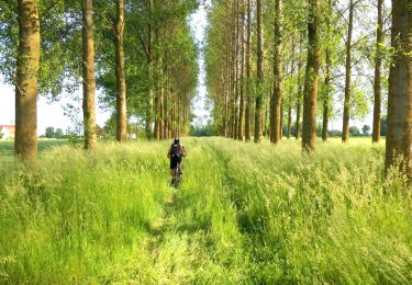
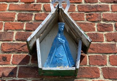
Dit circuit bestaat vooral uit aardewegen. Het voert u naar enkele grensdorpjes zoals Taintignies, Rumes, Esplechin, Froidmont, Willemeau enz... Het grootste gedeelte van het parcours doorkruist een vlak platteland met landbouwgronden. Alleen de heuvel met de Antenne de Froidmont heeft een iets meer uitgesproken reliëf. Deze tocht geeft ook toegang tot het «circuit des 5 forêts des Plaines de l'Escaut». Aarzel niet om nog enkele tochten te maken uit dit ruiterpadennet. Het dorpje la Glanerie in de fusiegemeente Rumes viert half augustus het oogstfeest zoals in de goede oude tijd. Neem inlichtingen en voorzie desgewenst een halte om de feestelijkheden bij te wonen.
Plaatsbepaling
Opmerkingen
Wandeltochten in de omgeving
![Tocht Te voet Doornik - Wandeling van de 'Mont au Gris' - Photo](https://media.geolcdn.com/t/375/260/ext.jpg?maxdim=2&url=https%3A%2F%2Fpivotmedia.tourismewallonie.be%2FANX-02-04JR-0001%2FANX-02-04JR-0001.JPG)
![Te voet Te voet](https://static1.geolcdn.com/sitytour/trail-icons/100.png)
Te voet
![](/images/other/stat-length.png)
![](https://static1.geolcdn.com/siteimages/upload/files/16400158638029165_repeat_loop_refresh_sync_direction_icon.png)
![Tocht Paard Rumes - Ruiterroute van Rumes - Photo](https://media.geolcdn.com/t/375/260/ext.jpg?maxdim=2&url=https%3A%2F%2Fpivotmedia.tourismewallonie.be%2FANX-02-000EI5%2FANX-02-000EI5.jpg)
![Paard Paard](https://static1.geolcdn.com/sitytour/trail-icons/300.png)
Paard
![](/images/other/stat-length.png)
![](https://static1.geolcdn.com/siteimages/upload/files/16400158638029165_repeat_loop_refresh_sync_direction_icon.png)
![Tocht Paard Brunehaut - Ruiterroute van Brunehaut - Photo](https://media.geolcdn.com/t/375/260/ext.jpg?maxdim=2&url=https%3A%2F%2Fpivotmedia.tourismewallonie.be%2FANX-02-000EI9%2FANX-02-000EI9.jpg)
![Paard Paard](https://static1.geolcdn.com/sitytour/trail-icons/300.png)
Paard
![](/images/other/stat-length.png)
![](https://static1.geolcdn.com/siteimages/upload/files/16400158638029165_repeat_loop_refresh_sync_direction_icon.png)
![Tocht Te voet Rumes - Circuit van het Pays des Mâchons - Photo](https://media.geolcdn.com/t/375/260/ext.jpg?maxdim=2&url=https%3A%2F%2Fpivotmedia.tourismewallonie.be%2FANX-02-03MU-02UJ%2FANX-02-03MU-02UJ.JPG)
![Te voet Te voet](https://static1.geolcdn.com/sitytour/trail-icons/100.png)
Te voet
![](/images/other/stat-length.png)
![](https://static1.geolcdn.com/siteimages/upload/files/16400158638029165_repeat_loop_refresh_sync_direction_icon.png)
![Tocht Te voet Brunehaut - Circuit van de boomkwekerijen van Lesdain - Photo](https://media.geolcdn.com/t/375/260/ext.jpg?maxdim=2&url=https%3A%2F%2Fpivotmedia.tourismewallonie.be%2FANX-02-04JM-0024%2FANX-02-04JM-0024.jpg)
![Te voet Te voet](https://static1.geolcdn.com/sitytour/trail-icons/100.png)
Te voet
![](/images/other/stat-length.png)
![](https://static1.geolcdn.com/siteimages/upload/files/16400158638029165_repeat_loop_refresh_sync_direction_icon.png)
![Tocht Stappen Brunehaut - RB - H - 15 Lesdain - Photo](https://media.geolcdn.com/t/375/260/ext.jpg?maxdim=2&url=https%3A%2F%2Fservices.sitytrail.com%2FGeolivesWS%2FDownloadMedia.ashx%3FTrailID%3D617918%26Media%3Dfix__20160820190940.jpg)
![Stappen Stappen](https://static1.geolcdn.com/sitytour/trail-icons/101.png)
Stappen
![](/images/other/stat-length.png)
![](https://static1.geolcdn.com/siteimages/upload/files/16400158638029165_repeat_loop_refresh_sync_direction_icon.png)
![Tocht Stappen Brunehaut - Rongy 11,1 km - Photo](https://media.geolcdn.com/t/375/260/f465c305-b738-40d1-b766-ceee6be80af7.jpg&format=jpg&maxdim=2)
![Stappen Stappen](https://static1.geolcdn.com/sitytour/trail-icons/101.png)
Stappen
![](/images/other/stat-length.png)
![](https://static1.geolcdn.com/siteimages/upload/files/16400158638029165_repeat_loop_refresh_sync_direction_icon.png)
![Tocht Mountainbike Rumes - Circuit van la Déroderie - Photo](https://media.geolcdn.com/t/375/260/ext.jpg?maxdim=2&url=https%3A%2F%2Fpivotmedia.tourismewallonie.be%2FANX-02-04SA-0001%2FANX-02-04SA-0001.jpg)
![Mountainbike Mountainbike](https://static1.geolcdn.com/sitytour/trail-icons/202.png)
Mountainbike
![](/images/other/stat-length.png)
![](https://static1.geolcdn.com/siteimages/upload/files/16400158638029165_repeat_loop_refresh_sync_direction_icon.png)
![Tocht Stappen Brunehaut - Les Vergers du Tournaisis - Photo](https://media.geolcdn.com/t/375/260/c9b3196c-a5f5-49bd-9d0f-43b6b6e00d5e.jpg&format=jpg&maxdim=2)
![Stappen Stappen](https://static1.geolcdn.com/sitytour/trail-icons/101.png)
Stappen
![](/images/other/stat-length.png)
![](https://static1.geolcdn.com/siteimages/upload/files/16400158638029165_repeat_loop_refresh_sync_direction_icon.png)