![](/images/other/stat-length.png)
![Tocht Mountainbike Péruwelz - Grensoverschrijdend circuit van de Vergne - Photo](https://media.geolcdn.com/t/1900/400/ext.pjpeg?maxdim=2&url=https%3A%2F%2Fpivotmedia.tourismewallonie.be%2FANX-02-000EXG%2FANX-02-000EXG.jpg)
Grensoverschrijdend circuit van de Vergne
Commissariat général au Tourisme
Randonnées du CGT GUIDE+
![Lengte](/images/other/stat-length.png)
![Max. hoogte](https://static1.geolcdn.com/siteimages/upload/files/1508320355ic_sort_altitude_max_24dp.png)
![Positief hoogteverschil](https://static1.geolcdn.com/siteimages/upload/files/1508320355ic_sort_den_pos_24dp.png)
![Km-Effort](/images/other/stat-length.png)
![Min. hoogte](https://static1.geolcdn.com/siteimages/upload/files/1508320355ic_sort_altitude_min_24dp.png)
![Negatief hoogteverschil](https://static1.geolcdn.com/siteimages/upload/files/1508320355ic_sort_den_neg_24dp.png)
![Boucle](https://static1.geolcdn.com/siteimages/upload/files/16400158638029165_repeat_loop_refresh_sync_direction_icon.png)
![Mountainbike](https://static1.geolcdn.com/sitytour/trail-icons/202.png)
1h22
Moeilijkheid : Gemakkelijk
![Scan deze QR-code om de tocht te openen in de SityTrail-applicatie](https://capi.geolives.com/qq0zvz2zws4bq2lad0pu/sitytour/trails/3081406/qr.png?size=200)
Gratisgps-wandelapplicatie
Over ons
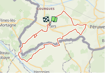
Tocht Mountainbike van 18,8 km beschikbaar op Wallonië, Henegouwen, Péruwelz. Deze tocht wordt voorgesteld door Commissariat général au Tourisme.
Beschrijving
Trail created by Wallonie Picarde (Antenne Tournai) .
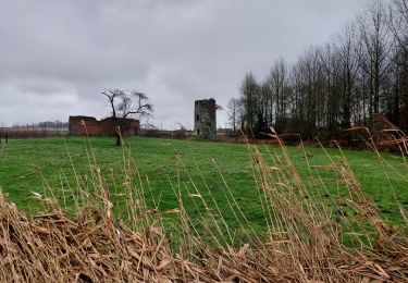
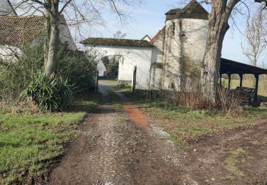
De fietsers bevinden zich in volle natuur, in fraaie landschappen met vochtige vlaktes en knotwilgen. Dit parcours laat de landelijke behuizing zien. Daarvan getuigen de vele boerderijen en de vredige weiden met paarden en koeien die men onderweg passeert. De privé-kastelen van Biez en Vergne, de ‘planche’ en andere verrassingen wachten op nieuwsgierige fietsers langs dit plat maar toch technisch parcours.
Plaatsbepaling
Opmerkingen
Wandeltochten in de omgeving
![Tocht Stappen Hergnies - Entre terre et eaux - Hergnies - Photo](https://media.geolcdn.com/t/375/260/ext.jpg?maxdim=2&url=https%3A%2F%2Fservices.sitytrail.com%2FGeolivesWS%2FDownloadMedia.ashx%3FTrailID%3D111915%26Media%3D8943_6.jpg)
![Stappen Stappen](https://static1.geolcdn.com/sitytour/trail-icons/101.png)
Stappen
![](/images/other/stat-length.png)
![](https://static1.geolcdn.com/siteimages/upload/files/16400158638029165_repeat_loop_refresh_sync_direction_icon.png)
![Tocht Stappen Péruwelz - PERUWELZ _ Marche Fédérale _ HT _ 14/05/2023 - Photo](https://media.geolcdn.com/t/375/260/5fb5656f-b658-42f9-b5fd-1aa9924cc25a.jpg&format=jpg&maxdim=2)
![Stappen Stappen](https://static1.geolcdn.com/sitytour/trail-icons/101.png)
Stappen
![](/images/other/stat-length.png)
![](https://static1.geolcdn.com/siteimages/upload/files/16400158638029165_repeat_loop_refresh_sync_direction_icon.png)
![Tocht Stappen Flines-lès-Mortagne - De Flines les Mortane à Bernissart (Belgique) - Photo](https://media.geolcdn.com/t/375/260/ca739f87-71b6-494f-8d4f-d2141a94b6cf.jpg&format=jpg&maxdim=2)
![Stappen Stappen](https://static1.geolcdn.com/sitytour/trail-icons/101.png)
Stappen
![](/images/other/stat-length.png)
![](https://static1.geolcdn.com/siteimages/upload/files/16400158638029165_repeat_loop_refresh_sync_direction_icon.png)
![Tocht Stappen Péruwelz - CALLENELLE _ Marche Fédérale _ HAIT _ 8/01/2022 - Photo](https://media.geolcdn.com/t/375/260/09c08405-e580-4a6b-bb6b-50c70ee88d38.jpg&format=jpg&maxdim=2)
![Stappen Stappen](https://static1.geolcdn.com/sitytour/trail-icons/101.png)
Stappen
![](/images/other/stat-length.png)
![](https://static1.geolcdn.com/siteimages/upload/files/16400158638029165_repeat_loop_refresh_sync_direction_icon.png)
![Stappen Stappen](https://static1.geolcdn.com/sitytour/trail-icons/101.png)
Stappen
![](/images/other/stat-length.png)
![](https://static1.geolcdn.com/siteimages/upload/files/16400158638029165_repeat_loop_refresh_sync_direction_icon.png)
![Tocht Stappen Nivelle - Nivelle- circuit Nivelle-Mortagne-Chateau l'abbaye - Photo](https://media.geolcdn.com/t/375/260/d91e613a-8448-41fc-bfd3-8fd05bd73b48.jpg&format=jpg&maxdim=2)
![Stappen Stappen](https://static1.geolcdn.com/sitytour/trail-icons/101.png)
Stappen
![](/images/other/stat-length.png)
![](https://static1.geolcdn.com/siteimages/upload/files/16400158638029165_repeat_loop_refresh_sync_direction_icon.png)
![Tocht Stappen Château-l'Abbaye - château l'abbaye. entre Escaut et Scarpe - Photo](https://media.geolcdn.com/t/375/260/21c122b9-cbf8-4e60-94a2-4e2f3c16b33a.jpg&format=jpg&maxdim=2)
![Stappen Stappen](https://static1.geolcdn.com/sitytour/trail-icons/101.png)
Stappen
![](/images/other/stat-length.png)
![](https://static1.geolcdn.com/siteimages/upload/files/16400158638029165_repeat_loop_refresh_sync_direction_icon.png)
![Tocht Te voet Péruwelz - 2021-02-17 11:38:21 - Photo](https://media.geolcdn.com/t/375/260/5055c7f9-3163-4866-b4bc-b6fa239b330b.jpg&format=jpg&maxdim=2)
![Te voet Te voet](https://static1.geolcdn.com/sitytour/trail-icons/100.png)
Te voet
![](/images/other/stat-length.png)
![](https://static1.geolcdn.com/siteimages/upload/files/16400158638029165_repeat_loop_refresh_sync_direction_icon.png)
![Tocht Stappen Péruwelz - roucourt 20 km 16 février 2021 - Photo](https://media.geolcdn.com/t/375/260/f847f3a8-68b8-4203-818a-f0ded88cb5ef.jpg&format=jpg&maxdim=2)
![Stappen Stappen](https://static1.geolcdn.com/sitytour/trail-icons/101.png)
Stappen
![](/images/other/stat-length.png)
![](https://static1.geolcdn.com/siteimages/upload/files/16400158638029165_repeat_loop_refresh_sync_direction_icon.png)