


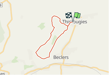


7,3 km | 8,7 km-effort

Randonnées du CGT GUIDE+


Gratisgps-wandelapplicatie
 SityTrail
IGN / Geografische instituten
SityTrail World
De wereld gaat voor u open
Tocht Te voet van 5,4 km beschikbaar op Wallonië, Henegouwen, Doornik. Deze tocht wordt voorgesteld door Commissariat général au Tourisme.
Trail created by Wallonie Picarde (Antenne Tournai) .
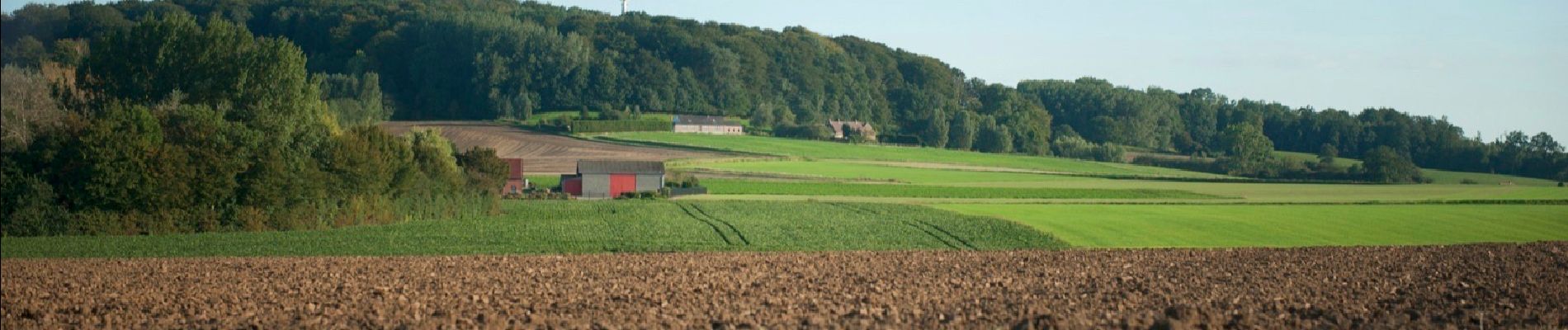
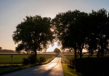
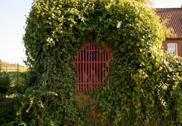
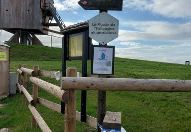
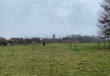
Dit charmante dorpje wordt ooit nog we leens lid van de vereniging van mooiste dorpen van Wallonië. Dit label verdient het vanwege zijn erfgoedschatten en zijn bewaard gebleven landelijk karakter, maar ook vanwege het dynamisme van zijn inwoners. Elke dag zijn de wegen er bezaaid met joggers, wandelaars, fietsers en toeristen die van alle kanten opduiken. Ze komen vooral voor de open, beboste of golvende landschappen van het Doornikse heuvelland. ‘Als je eenmaal van Thimougies hebt geproefd, kan je nooit meer zonder’ luidt de slogan van de lokale vereniging vzw Moulin à Vent.
 "
data-pinterest-text="Pin it"
data-tweet-text="share on twitter"
data-facebook-share-url="https://www.sitytrail.com/nl/trails/3081389-doornik--wandeling-van-xle-vertxboisx/?photo=1#lg=1&slide=1"
data-twitter-share-url="https://www.sitytrail.com/nl/trails/3081389-doornik--wandeling-van-xle-vertxboisx/?photo=1#lg=1&slide=1"
data-googleplus-share-url="https://www.sitytrail.com/nl/trails/3081389-doornik--wandeling-van-xle-vertxboisx/?photo=1#lg=1&slide=1"
data-pinterest-share-url="https://www.sitytrail.com/nl/trails/3081389-doornik--wandeling-van-xle-vertxboisx/?photo=1#lg=1&slide=1">
"
data-pinterest-text="Pin it"
data-tweet-text="share on twitter"
data-facebook-share-url="https://www.sitytrail.com/nl/trails/3081389-doornik--wandeling-van-xle-vertxboisx/?photo=1#lg=1&slide=1"
data-twitter-share-url="https://www.sitytrail.com/nl/trails/3081389-doornik--wandeling-van-xle-vertxboisx/?photo=1#lg=1&slide=1"
data-googleplus-share-url="https://www.sitytrail.com/nl/trails/3081389-doornik--wandeling-van-xle-vertxboisx/?photo=1#lg=1&slide=1"
data-pinterest-share-url="https://www.sitytrail.com/nl/trails/3081389-doornik--wandeling-van-xle-vertxboisx/?photo=1#lg=1&slide=1">
 "
data-pinterest-text="Pin it"
data-tweet-text="share on twitter"
data-facebook-share-url="https://www.sitytrail.com/nl/trails/3081389-doornik--wandeling-van-xle-vertxboisx/?photo=2#lg=1&slide=2"
data-twitter-share-url="https://www.sitytrail.com/nl/trails/3081389-doornik--wandeling-van-xle-vertxboisx/?photo=2#lg=1&slide=2"
data-googleplus-share-url="https://www.sitytrail.com/nl/trails/3081389-doornik--wandeling-van-xle-vertxboisx/?photo=2#lg=1&slide=2"
data-pinterest-share-url="https://www.sitytrail.com/nl/trails/3081389-doornik--wandeling-van-xle-vertxboisx/?photo=2#lg=1&slide=2">
"
data-pinterest-text="Pin it"
data-tweet-text="share on twitter"
data-facebook-share-url="https://www.sitytrail.com/nl/trails/3081389-doornik--wandeling-van-xle-vertxboisx/?photo=2#lg=1&slide=2"
data-twitter-share-url="https://www.sitytrail.com/nl/trails/3081389-doornik--wandeling-van-xle-vertxboisx/?photo=2#lg=1&slide=2"
data-googleplus-share-url="https://www.sitytrail.com/nl/trails/3081389-doornik--wandeling-van-xle-vertxboisx/?photo=2#lg=1&slide=2"
data-pinterest-share-url="https://www.sitytrail.com/nl/trails/3081389-doornik--wandeling-van-xle-vertxboisx/?photo=2#lg=1&slide=2">
 "
data-pinterest-text="Pin it"
data-tweet-text="share on twitter"
data-facebook-share-url="https://www.sitytrail.com/nl/trails/3081389-doornik--wandeling-van-xle-vertxboisx/?photo=3#lg=1&slide=3"
data-twitter-share-url="https://www.sitytrail.com/nl/trails/3081389-doornik--wandeling-van-xle-vertxboisx/?photo=3#lg=1&slide=3"
data-googleplus-share-url="https://www.sitytrail.com/nl/trails/3081389-doornik--wandeling-van-xle-vertxboisx/?photo=3#lg=1&slide=3"
data-pinterest-share-url="https://www.sitytrail.com/nl/trails/3081389-doornik--wandeling-van-xle-vertxboisx/?photo=3#lg=1&slide=3">
"
data-pinterest-text="Pin it"
data-tweet-text="share on twitter"
data-facebook-share-url="https://www.sitytrail.com/nl/trails/3081389-doornik--wandeling-van-xle-vertxboisx/?photo=3#lg=1&slide=3"
data-twitter-share-url="https://www.sitytrail.com/nl/trails/3081389-doornik--wandeling-van-xle-vertxboisx/?photo=3#lg=1&slide=3"
data-googleplus-share-url="https://www.sitytrail.com/nl/trails/3081389-doornik--wandeling-van-xle-vertxboisx/?photo=3#lg=1&slide=3"
data-pinterest-share-url="https://www.sitytrail.com/nl/trails/3081389-doornik--wandeling-van-xle-vertxboisx/?photo=3#lg=1&slide=3">
 "
data-pinterest-text="Pin it"
data-tweet-text="share on twitter"
data-facebook-share-url="https://www.sitytrail.com/nl/trails/3081389-doornik--wandeling-van-xle-vertxboisx/?photo=4#lg=1&slide=4"
data-twitter-share-url="https://www.sitytrail.com/nl/trails/3081389-doornik--wandeling-van-xle-vertxboisx/?photo=4#lg=1&slide=4"
data-googleplus-share-url="https://www.sitytrail.com/nl/trails/3081389-doornik--wandeling-van-xle-vertxboisx/?photo=4#lg=1&slide=4"
data-pinterest-share-url="https://www.sitytrail.com/nl/trails/3081389-doornik--wandeling-van-xle-vertxboisx/?photo=4#lg=1&slide=4">
"
data-pinterest-text="Pin it"
data-tweet-text="share on twitter"
data-facebook-share-url="https://www.sitytrail.com/nl/trails/3081389-doornik--wandeling-van-xle-vertxboisx/?photo=4#lg=1&slide=4"
data-twitter-share-url="https://www.sitytrail.com/nl/trails/3081389-doornik--wandeling-van-xle-vertxboisx/?photo=4#lg=1&slide=4"
data-googleplus-share-url="https://www.sitytrail.com/nl/trails/3081389-doornik--wandeling-van-xle-vertxboisx/?photo=4#lg=1&slide=4"
data-pinterest-share-url="https://www.sitytrail.com/nl/trails/3081389-doornik--wandeling-van-xle-vertxboisx/?photo=4#lg=1&slide=4">
 "
data-pinterest-text="Pin it"
data-tweet-text="share on twitter"
data-facebook-share-url="https://www.sitytrail.com/nl/trails/3081389-doornik--wandeling-van-xle-vertxboisx/?photo=5#lg=1&slide=5"
data-twitter-share-url="https://www.sitytrail.com/nl/trails/3081389-doornik--wandeling-van-xle-vertxboisx/?photo=5#lg=1&slide=5"
data-googleplus-share-url="https://www.sitytrail.com/nl/trails/3081389-doornik--wandeling-van-xle-vertxboisx/?photo=5#lg=1&slide=5"
data-pinterest-share-url="https://www.sitytrail.com/nl/trails/3081389-doornik--wandeling-van-xle-vertxboisx/?photo=5#lg=1&slide=5">
"
data-pinterest-text="Pin it"
data-tweet-text="share on twitter"
data-facebook-share-url="https://www.sitytrail.com/nl/trails/3081389-doornik--wandeling-van-xle-vertxboisx/?photo=5#lg=1&slide=5"
data-twitter-share-url="https://www.sitytrail.com/nl/trails/3081389-doornik--wandeling-van-xle-vertxboisx/?photo=5#lg=1&slide=5"
data-googleplus-share-url="https://www.sitytrail.com/nl/trails/3081389-doornik--wandeling-van-xle-vertxboisx/?photo=5#lg=1&slide=5"
data-pinterest-share-url="https://www.sitytrail.com/nl/trails/3081389-doornik--wandeling-van-xle-vertxboisx/?photo=5#lg=1&slide=5">

Stappen
Stappen

Te voet
Te voet
Te voet

Te voet
Stappen

Te voet
Stappen