![](/images/other/stat-length.png)
![Tocht Te voet Frasnes-lez-Anvaing - De 'Mooie Plekjes' van Saint-Sauveur - Photo](https://media.geolcdn.com/t/1900/400/ext.pjpeg?maxdim=2&url=https%3A%2F%2Fpivotmedia.tourismewallonie.be%2FANX-02-03XZ-0092%2FANX-02-03XZ-0092.jpg)
De 'Mooie Plekjes' van Saint-Sauveur
Commissariat général au Tourisme
Randonnées du CGT GUIDE+
![Lengte](/images/other/stat-length.png)
![Max. hoogte](https://static1.geolcdn.com/siteimages/upload/files/1508320355ic_sort_altitude_max_24dp.png)
![Positief hoogteverschil](https://static1.geolcdn.com/siteimages/upload/files/1508320355ic_sort_den_pos_24dp.png)
![Km-Effort](/images/other/stat-length.png)
![Min. hoogte](https://static1.geolcdn.com/siteimages/upload/files/1508320355ic_sort_altitude_min_24dp.png)
![Negatief hoogteverschil](https://static1.geolcdn.com/siteimages/upload/files/1508320355ic_sort_den_neg_24dp.png)
![Boucle](https://static1.geolcdn.com/siteimages/upload/files/16400158638029165_repeat_loop_refresh_sync_direction_icon.png)
![Te voet](https://static1.geolcdn.com/sitytour/trail-icons/100.png)
2h58
Moeilijkheid : Gemakkelijk
![Scan deze QR-code om de tocht te openen in de SityTrail-applicatie](https://capi.geolives.com/qq0zvz2zws4bq2lad0pu/sitytour/trails/3081388/qr.png?size=200)
Gratisgps-wandelapplicatie
Over ons
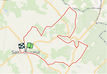
Tocht Te voet van 10,9 km beschikbaar op Wallonië, Henegouwen, Frasnes-lez-Anvaing. Deze tocht wordt voorgesteld door Commissariat général au Tourisme.
Beschrijving
Trail created by Wallonie Picarde (Antenne Tournai) .
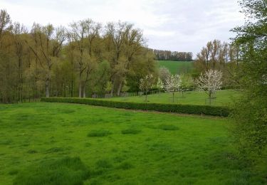
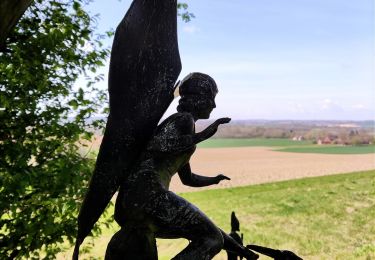
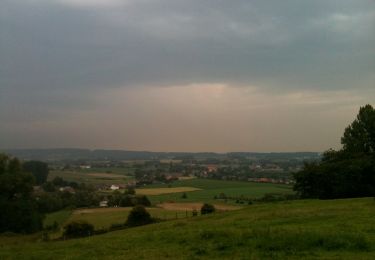
De kleine wandeling die klimt en klimt ... brengt ons naar de'berg'van Saint-Sauveur, 133 meter hoog. Het is een plaats waar men gezonde lucht inademt en het oog verwend wordt met een wijds panorama. Langs rustige, kronkelende wegen in een groene omgeving met rode daken laat deze landelijke route u kennismaken met een voormalige drukke vakantiebestemming: de “Beau Site”.
Knooppunten : VERTREKPUNT Place de Saint-Sauveur- 28-36-35- Place de Saint-Sauveur tot 28 EINDPUNT
Plaatsbepaling
Opmerkingen
Wandeltochten in de omgeving
![Tocht Elektrische fiets Ronse - Ellezelles par petits chemins pittoresques - Photo](https://media.geolcdn.com/t/375/260/e0aa3d15-f60d-4f83-a5a3-a0f3e8c9900b.jpg&format=jpg&maxdim=2)
![Elektrische fiets Elektrische fiets](https://static1.geolcdn.com/sitytour/trail-icons/205.png)
Elektrische fiets
![](/images/other/stat-length.png)
![](https://static1.geolcdn.com/siteimages/upload/files/16400158638029165_repeat_loop_refresh_sync_direction_icon.png)
![Tocht Mountainbike Ronse - Vers Musiekbos - Photo](https://media.geolcdn.com/t/375/260/ext.jpg?maxdim=2&url=https%3A%2F%2Fservices.sitytrail.com%2FGeolivesWS%2FDownloadMedia.ashx%3FTrailID%3D412567%26Media%3Dfix__20150426141940.jpg)
![Mountainbike Mountainbike](https://static1.geolcdn.com/sitytour/trail-icons/202.png)
Mountainbike
![](/images/other/stat-length.png)
![](https://static1.geolcdn.com/siteimages/upload/files/16400158638029165_repeat_loop_refresh_sync_direction_icon.png)
![Tocht Stappen Frasnes-lez-Anvaing - Le sentier enchanté - Photo](https://media.geolcdn.com/t/375/260/ext.jpg?maxdim=2&url=https%3A%2F%2Fservices.sitytrail.com%2FGeolivesWS%2FDownloadMedia.ashx%3FTrailID%3D202843%26Media%3D9c77b90c-b972-42b8-8b63-def1b282e453.jpg)
![Stappen Stappen](https://static1.geolcdn.com/sitytour/trail-icons/101.png)
Stappen
![](/images/other/stat-length.png)
![](https://static1.geolcdn.com/siteimages/upload/files/16400158638029165_repeat_loop_refresh_sync_direction_icon.png)
![Tocht Stappen Frasnes-lez-Anvaing - Le sentier enchanté - Photo](https://media.geolcdn.com/t/375/260/4c4c9013-0630-45d5-8667-6a80dbaf92e9.jpg&format=jpg&maxdim=2)
![Stappen Stappen](https://static1.geolcdn.com/sitytour/trail-icons/101.png)
Stappen
![](/images/other/stat-length.png)
![](https://static1.geolcdn.com/siteimages/upload/files/16400158638029165_repeat_loop_refresh_sync_direction_icon.png)
![Tocht Te voet Frasnes-lez-Anvaing - Le sentier Enchanté - Photo](https://media.geolcdn.com/t/375/260/b7b629eb-bc00-4938-8602-679c63657406.jpeg&format=jpg&maxdim=2)
![Te voet Te voet](https://static1.geolcdn.com/sitytour/trail-icons/100.png)
Te voet
![](/images/other/stat-length.png)
![](https://static1.geolcdn.com/siteimages/upload/files/16400158638029165_repeat_loop_refresh_sync_direction_icon.png)
![Tocht Te voet Frasnes-lez-Anvaing - Le sentier de l'Amour - Photo](https://media.geolcdn.com/t/375/260/b7b629eb-bc00-4938-8602-679c63657406.jpeg&format=jpg&maxdim=2)
![Te voet Te voet](https://static1.geolcdn.com/sitytour/trail-icons/100.png)
Te voet
![](/images/other/stat-length.png)
![](https://static1.geolcdn.com/siteimages/upload/files/16400158638029165_repeat_loop_refresh_sync_direction_icon.png)
![Tocht Te voet Frasnes-lez-Anvaing - De opmerkelijke boerderijen en kastelen - Photo](https://media.geolcdn.com/t/375/260/ext.jpg?maxdim=2&url=https%3A%2F%2Fpivotmedia.tourismewallonie.be%2FANX-02-000EMQ%2FANX-02-000EMQ.jpg)
![Te voet Te voet](https://static1.geolcdn.com/sitytour/trail-icons/100.png)
Te voet
![](/images/other/stat-length.png)
![](https://static1.geolcdn.com/siteimages/upload/files/16400158638029165_repeat_loop_refresh_sync_direction_icon.png)
![Tocht Te voet Frasnes-lez-Anvaing - Het kasteel van Anvaing en zijn slotgracht - Photo](https://media.geolcdn.com/t/375/260/ext.jpg?maxdim=2&url=https%3A%2F%2Fpivotmedia.tourismewallonie.be%2FANX-02-000EMX%2FANX-02-000EMX.jpg)
![Te voet Te voet](https://static1.geolcdn.com/sitytour/trail-icons/100.png)
Te voet
![](/images/other/stat-length.png)
![](https://static1.geolcdn.com/siteimages/upload/files/16400158638029165_repeat_loop_refresh_sync_direction_icon.png)
![Tocht Mountainbike Frasnes-lez-Anvaing - Door bossen en het platteland - Photo](https://media.geolcdn.com/t/375/260/ext.jpg?maxdim=2&url=https%3A%2F%2Fpivotmedia.tourismewallonie.be%2FANX-02-000EX4%2FANX-02-000EX4.jpg)
![Mountainbike Mountainbike](https://static1.geolcdn.com/sitytour/trail-icons/202.png)
Mountainbike
![](/images/other/stat-length.png)
![](https://static1.geolcdn.com/siteimages/upload/files/16400158638029165_repeat_loop_refresh_sync_direction_icon.png)