![](/images/other/stat-length.png)
![Tocht Te voet Hamoir - Rondom Fairon - Photo](https://media.geolcdn.com/t/1900/400/ext.pjpeg?maxdim=2&url=https%3A%2F%2Fpivotmedia.tourismewallonie.be%2FANX-0W-000PBS%2FANX-0W-000PBS.jpg)
Rondom Fairon
Commissariat général au Tourisme
Randonnées du CGT GUIDE+
![Lengte](/images/other/stat-length.png)
![Max. hoogte](https://static1.geolcdn.com/siteimages/upload/files/1508320355ic_sort_altitude_max_24dp.png)
![Positief hoogteverschil](https://static1.geolcdn.com/siteimages/upload/files/1508320355ic_sort_den_pos_24dp.png)
![Km-Effort](/images/other/stat-length.png)
![Min. hoogte](https://static1.geolcdn.com/siteimages/upload/files/1508320355ic_sort_altitude_min_24dp.png)
![Negatief hoogteverschil](https://static1.geolcdn.com/siteimages/upload/files/1508320355ic_sort_den_neg_24dp.png)
![Boucle](https://static1.geolcdn.com/siteimages/upload/files/16400158638029165_repeat_loop_refresh_sync_direction_icon.png)
![Te voet](https://static1.geolcdn.com/sitytour/trail-icons/100.png)
1h44
Moeilijkheid : Gemakkelijk
![Scan deze QR-code om de tocht te openen in de SityTrail-applicatie](https://capi.geolives.com/qq0zvz2zws4bq2lad0pu/sitytour/trails/3080434/qr.png?size=200)
Gratisgps-wandelapplicatie
Over ons
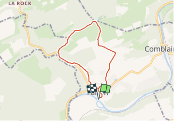
Tocht Te voet van 5,8 km beschikbaar op Wallonië, Luik, Hamoir. Deze tocht wordt voorgesteld door Commissariat général au Tourisme.
Beschrijving
Trail created by Ourthe Vesdre Amblève.
Deze wandeling vertrekt vanuit vanuit Fairon. Hier ontdekt u het vroegere Hof van Justitie. We volgen de Bloquay-beek tot aan de Molen van Bloquay (geklasseerd), een (weer in gebruik genomen) steengroeve. Na de kleine brug vervolgt u de weg richting Tolumont naar Sablières (geklasseerde site) om omhoog te gaan richting het gehucht "Au-dela-des-Monts" (panorama met uitzicht op de vallei van de Ourthe en zijn omgeving). Retour naar het dorp Fairon.
Plaatsbepaling
Opmerkingen
Wandeltochten in de omgeving
![Tocht Stappen Hamoir - RB-Lg-19_Hamoir - Photo](https://media.geolcdn.com/t/375/260/ext.jpg?maxdim=2&url=https%3A%2F%2Fservices.sitytrail.com%2FGeolivesWS%2FDownloadMedia.ashx%3FTrailID%3D400602%26Media%3Dc0745639-8ded-479e-9345-a8c68cd61e6a.jpg)
![Stappen Stappen](https://static1.geolcdn.com/sitytour/trail-icons/101.png)
Stappen
![](/images/other/stat-length.png)
![](https://static1.geolcdn.com/siteimages/upload/files/16400158638029165_repeat_loop_refresh_sync_direction_icon.png)
![Stappen Stappen](https://static1.geolcdn.com/sitytour/trail-icons/101.png)
Stappen
![](/images/other/stat-length.png)
![](https://static1.geolcdn.com/siteimages/upload/files/16400158638029165_repeat_loop_refresh_sync_direction_icon.png)
![Tocht Stappen Comblain-au-Pont - RF-Lg-04_Comblain-au-Pont_Grande-boucle - Photo](https://media.geolcdn.com/t/375/260/b6c1584e-1801-407f-b05d-19d8f1862ff5.jpg&format=jpg&maxdim=2)
![Stappen Stappen](https://static1.geolcdn.com/sitytour/trail-icons/101.png)
Stappen
![](/images/other/stat-length.png)
![](https://static1.geolcdn.com/siteimages/upload/files/16400158638029165_repeat_loop_refresh_sync_direction_icon.png)
![Tocht Stappen Comblain-au-Pont - 2021-06-30_15h22m22_Cirkwi-Autour_de_Comblain-au-Pont_-_Promenade_3___Four_à_chaux_-_Mont_-_Poulseur_-_Canal_de_l_Ourthe_-_Rivage - Photo](https://media.geolcdn.com/t/375/260/e3bd39c1-3623-4715-901d-7409f699ba3a.jpg&format=jpg&maxdim=2)
![Stappen Stappen](https://static1.geolcdn.com/sitytour/trail-icons/101.png)
Stappen
![](/images/other/stat-length.png)
![](https://static1.geolcdn.com/siteimages/upload/files/16400158638029165_repeat_loop_refresh_sync_direction_icon.png)
![Tocht Stappen Comblain-au-Pont - 2021-05-13_19h25m39_Cirkwi-Autour_de_Comblain-au-Pont_-_Promenade_10___Thier_Pirard_-_Hoyemont_-_Comblinay_-_Comblain-la-Tour_-_Comblain-au-Pont - Photo](https://media.geolcdn.com/t/375/260/978e853c-be9c-453e-b61f-b42dde075b4b.jpg&format=jpg&maxdim=2)
![Stappen Stappen](https://static1.geolcdn.com/sitytour/trail-icons/101.png)
Stappen
![](/images/other/stat-length.png)
![](https://static1.geolcdn.com/siteimages/upload/files/16400158638029165_repeat_loop_refresh_sync_direction_icon.png)
![Tocht Stappen Comblain-au-Pont - 2021-04-04_15h31m49_Cirkwi-Autour_de_Comblain-au-Pont_-_Promenade_9___Grotte_-_Raideux_-_Anthisnes_-_Les_Stepennes_-_Géromont - Photo](https://media.geolcdn.com/t/375/260/edfd852c-0012-45e6-9a23-c8c8cd48cf84.jpg&format=jpg&maxdim=2)
![Stappen Stappen](https://static1.geolcdn.com/sitytour/trail-icons/101.png)
Stappen
![](/images/other/stat-length.png)
![](https://static1.geolcdn.com/siteimages/upload/files/16400158638029165_repeat_loop_refresh_sync_direction_icon.png)
![Tocht Stappen Anthisnes - Anthines - AS03 - Boucle de Tolumont - Losange Bleu - Photo](https://media.geolcdn.com/t/375/260/a3413dfd-3361-4d9b-b91d-7efec18943a3.jpg&format=jpg&maxdim=2)
![Stappen Stappen](https://static1.geolcdn.com/sitytour/trail-icons/101.png)
Stappen
![](/images/other/stat-length.png)
![](https://static1.geolcdn.com/siteimages/upload/files/16400158638029165_repeat_loop_refresh_sync_direction_icon.png)
![Tocht Stappen Hamoir - HAMOIR (Vallée du Neblon) - Photo](https://media.geolcdn.com/t/375/260/bd133f9f-5595-47e8-88c0-4d09e83d3ba8.jpg&format=jpg&maxdim=2)
![Stappen Stappen](https://static1.geolcdn.com/sitytour/trail-icons/101.png)
Stappen
![](/images/other/stat-length.png)
![](https://static1.geolcdn.com/siteimages/upload/files/16400158638029165_repeat_loop_refresh_sync_direction_icon.png)
![Tocht Te voet Anthisnes - AS03 Boucle de Tolumont - Photo](https://media.geolcdn.com/t/375/260/bb3be3cf-eddc-4622-8273-ff9944f2671c.jpg&format=jpg&maxdim=2)
![Te voet Te voet](https://static1.geolcdn.com/sitytour/trail-icons/100.png)
Te voet
![](/images/other/stat-length.png)
![](https://static1.geolcdn.com/siteimages/upload/files/16400158638029165_repeat_loop_refresh_sync_direction_icon.png)