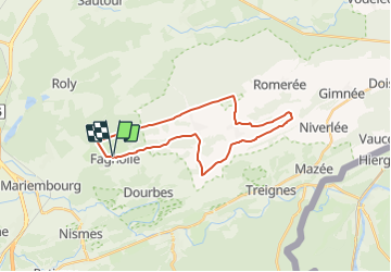
![](/images/other/stat-length.png)
![Tocht Mountainbike Philippeville - Circuit des Tiennes - Photo](https://media.geolcdn.com/t/1900/400/ext.pjpeg?maxdim=2&url=https%3A%2F%2Fpivotmedia.tourismewallonie.be%2FOTH-A0-004F-1T19%2FOTH-A0-004F-1T19.jpg)
Circuit des Tiennes
Commissariat général au Tourisme
Randonnées du CGT GUIDE+
![Lengte](/images/other/stat-length.png)
![Max. hoogte](https://static1.geolcdn.com/siteimages/upload/files/1508320355ic_sort_altitude_max_24dp.png)
![Positief hoogteverschil](https://static1.geolcdn.com/siteimages/upload/files/1508320355ic_sort_den_pos_24dp.png)
![Km-Effort](/images/other/stat-length.png)
![Min. hoogte](https://static1.geolcdn.com/siteimages/upload/files/1508320355ic_sort_altitude_min_24dp.png)
![Negatief hoogteverschil](https://static1.geolcdn.com/siteimages/upload/files/1508320355ic_sort_den_neg_24dp.png)
![Boucle](https://static1.geolcdn.com/siteimages/upload/files/16400158638029165_repeat_loop_refresh_sync_direction_icon.png)
![Mountainbike](https://static1.geolcdn.com/sitytour/trail-icons/202.png)
1h49
Moeilijkheid : Medium
![Scan deze QR-code om de tocht te openen in de SityTrail-applicatie](https://capi.geolives.com/qq0zvz2zws4bq2lad0pu/sitytour/trails/3080210/qr.png?size=200)
Gratisgps-wandelapplicatie
Over ons
Tocht Mountainbike van 23 km beschikbaar op Wallonië, Namen, Philippeville. Deze tocht wordt voorgesteld door Commissariat général au Tourisme.
Beschrijving
Trail created by Pays des Lacs.
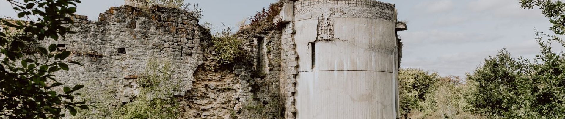
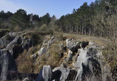
Dit parcours begint in de bossen van het gehucht Le Grand Tienne. Het loopt langs de ruïne van het middeleeuws kasteel Fagnolle, dat werd opgebouwd uit kalksteen uit de streek la Calestienne. Deze middeleeuwse vesting werd eind 12e eeuw opgericht op een motte en is een van de zeldzame voorbeelden van een laaglandkasteel in de streek. Op de heuvels van het dorp gaat het parcours verder in de richting van Matagne-la-Grande en Matagne-la-Petite waar de uitgestrekte velden en bossen u trakteren op prachtige vergezichten. Vervolgens ontdekt u de kapel Saint-Hilaire, gebouwd rond de 11e eeuw. De terugtocht naar Fagnolle gebeurt uitsluitend langs de voormalige spoorlijn.
Plaatsbepaling
Opmerkingen
Wandeltochten in de omgeving
![Tocht Stappen Couvin - Randonnée géologique - Photo](https://media.geolcdn.com/t/375/260/ext.jpg?maxdim=2&url=https%3A%2F%2Fservices.sitytrail.com%2FGeolivesWS%2FDownloadMedia.ashx%3FTrailID%3D535563%26Media%3D1ffcf5ce-1a74-4050-b18b-23e492a14ad7.jpg)
![Stappen Stappen](https://static1.geolcdn.com/sitytour/trail-icons/101.png)
Stappen
![](/images/other/stat-length.png)
![](https://static1.geolcdn.com/siteimages/upload/files/16400158638029165_repeat_loop_refresh_sync_direction_icon.png)
![Tocht Stappen Viroinval - RB-Na-13 Tiennes et vallons de la Calestienne - Photo](https://media.geolcdn.com/t/375/260/ext.jpg?maxdim=2&url=https%3A%2F%2Fservices.sitytrail.com%2FGeolivesWS%2FDownloadMedia.ashx%3FTrailID%3D260747%26Media%3Dff8837a8-8f2b-4db1-ba1e-88015d1f5e8a.jpg)
![Stappen Stappen](https://static1.geolcdn.com/sitytour/trail-icons/101.png)
Stappen
![](/images/other/stat-length.png)
![](https://static1.geolcdn.com/siteimages/upload/files/16400158638029165_repeat_loop_refresh_sync_direction_icon.png)
![Tocht Stappen Viroinval - Balade dans le Viroinval - De Vierves à Olloy - Photo](https://media.geolcdn.com/t/375/260/eea3f008-fef3-4865-8c34-a0378b4c67ed.jpeg&format=jpg&maxdim=2)
![Stappen Stappen](https://static1.geolcdn.com/sitytour/trail-icons/101.png)
Stappen
![](/images/other/stat-length.png)
![](https://static1.geolcdn.com/siteimages/upload/files/16400158638029165_repeat_loop_refresh_sync_direction_icon.png)
![Tocht Fiets Viroinval - À la découverte de Viroinval - Photo](https://media.geolcdn.com/t/375/260/ext.jpg?maxdim=2&url=https%3A%2F%2Fservices.sitytrail.com%2FGeolivesWS%2FDownloadMedia.ashx%3FTrailID%3D551547%26Media%3D1e3b4634-36c4-481a-a49d-2f3fedd5bc9a.JPG)
![Fiets Fiets](https://static1.geolcdn.com/sitytour/trail-icons/200.png)
Fiets
![](/images/other/stat-length.png)
![](https://static1.geolcdn.com/siteimages/upload/files/16400158638029165_repeat_loop_refresh_sync_direction_icon.png)
![Tocht Stappen Viroinval - Balade dans le Viroinval - De Vierves à Olloy - Photo](https://media.geolcdn.com/t/375/260/ext.jpg?maxdim=2&url=https%3A%2F%2Fservices.sitytrail.com%2FGeolivesWS%2FDownloadMedia.ashx%3FTrailID%3D394463%26Media%3D8cd58c74-46af-4e33-ad1f-b804c133f48a.JPG)
![Stappen Stappen](https://static1.geolcdn.com/sitytour/trail-icons/101.png)
Stappen
![](/images/other/stat-length.png)
![](https://static1.geolcdn.com/siteimages/upload/files/16400158638029165_repeat_loop_refresh_sync_direction_icon.png)
![Tocht Stappen Viroinval - Vierves. Natura 2000, des sites qui valent le détour ! Na6 - Photo](https://media.geolcdn.com/t/375/260/ext.jpg?maxdim=2&url=https%3A%2F%2Fservices.sitytrail.com%2FGeolivesWS%2FDownloadMedia.ashx%3FTrailID%3D161505%26Media%3Dd444d70d-cecc-46cd-9982-c53f323c2b51.jpg)
![Stappen Stappen](https://static1.geolcdn.com/sitytour/trail-icons/101.png)
Stappen
![](/images/other/stat-length.png)
![](https://static1.geolcdn.com/siteimages/upload/files/16400158638029165_repeat_loop_refresh_sync_direction_icon.png)
![Tocht Mountainbike Viroinval - Vierves - Olloy - Petigny - Nismes - Photo](https://media.geolcdn.com/t/375/260/d0c4d464-3769-46ce-b3d8-dcecdd33235b.jpeg&format=jpg&maxdim=2)
![Mountainbike Mountainbike](https://static1.geolcdn.com/sitytour/trail-icons/202.png)
Mountainbike
![](/images/other/stat-length.png)
![](https://static1.geolcdn.com/siteimages/upload/files/16400158638029165_repeat_loop_refresh_sync_direction_icon.png)
![Tocht Stappen Viroinval - fondry des chiens - Photo](https://media.geolcdn.com/t/375/260/ext.jpg?maxdim=2&url=https%3A%2F%2Fservices.sitytrail.com%2FGeolivesWS%2FDownloadMedia.ashx%3FTrailID%3D629836%26Media%3Dfix__20160911163715.jpg)
![Stappen Stappen](https://static1.geolcdn.com/sitytour/trail-icons/101.png)
Stappen
![](/images/other/stat-length.png)
![](https://static1.geolcdn.com/siteimages/upload/files/16400158638029165_repeat_loop_refresh_sync_direction_icon.png)
![Tocht Stappen Couvin - RF-Na-11-Neptune_Petite-boucle - Photo](https://media.geolcdn.com/t/375/260/ext.jpg?maxdim=2&url=https%3A%2F%2Fservices.sitytrail.com%2FGeolivesWS%2FDownloadMedia.ashx%3FTrailID%3D545771%26Media%3Dceaef66d-674f-485f-bb67-ca6ebb407dac.JPG)
![Stappen Stappen](https://static1.geolcdn.com/sitytour/trail-icons/101.png)
Stappen
![](/images/other/stat-length.png)
![](https://static1.geolcdn.com/siteimages/upload/files/16400158638029165_repeat_loop_refresh_sync_direction_icon.png)