![](/images/other/stat-length.png)
![Tocht Stappen Issac - Issac Issac 14km - Photo](https://media.geolcdn.com/t/1900/400/ext.pjpeg?maxdim=2&url=https%3A%2F%2Fstatic1.geolcdn.com%2Fsiteimages%2Fupload%2Ffiles%2F1553511878bg_sport_marche.png)
Issac Issac 14km
YV24
Gebruiker
![Lengte](/images/other/stat-length.png)
Lengte
13,7 km
![Max. hoogte](https://static1.geolcdn.com/siteimages/upload/files/1508320355ic_sort_altitude_max_24dp.png)
Max. hoogte
167 m
![Positief hoogteverschil](https://static1.geolcdn.com/siteimages/upload/files/1508320355ic_sort_den_pos_24dp.png)
Positief hoogteverschil
250 m
![Km-Effort](/images/other/stat-length.png)
Km-Effort
17 km
![Min. hoogte](https://static1.geolcdn.com/siteimages/upload/files/1508320355ic_sort_altitude_min_24dp.png)
Min. hoogte
70 m
![Negatief hoogteverschil](https://static1.geolcdn.com/siteimages/upload/files/1508320355ic_sort_den_neg_24dp.png)
Negatief hoogteverschil
248 m
![Boucle](https://static1.geolcdn.com/siteimages/upload/files/16400158638029165_repeat_loop_refresh_sync_direction_icon.png)
Boucle
Ja
Datum van aanmaak :
2014-12-10 00:00:00.0
Laatste wijziging :
2014-12-10 00:00:00.0
![Stappen](https://static1.geolcdn.com/sitytour/trail-icons/101.png)
3h34
Moeilijkheid : Gemakkelijk
![Scan deze QR-code om de tocht te openen in de SityTrail-applicatie](https://capi.geolives.com/qq0zvz2zws4bq2lad0pu/sitytour/trails/307863/qr.png?size=200)
Gratisgps-wandelapplicatie
Over ons
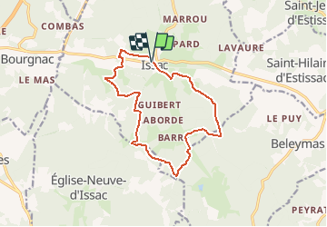
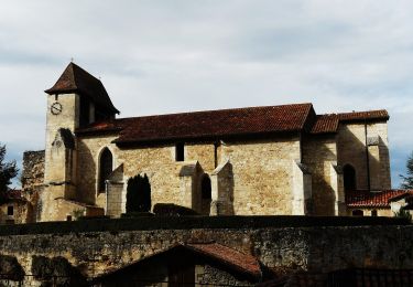
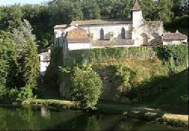
Tocht Stappen van 13,7 km beschikbaar op Nieuw-Aquitanië, Dordogne, Issac. Deze tocht wordt voorgesteld door YV24.
Beschrijving
Boucle autour d'Issac. Tracé varié, avec pas mal de bitume, partiellement ombragé, praticable en tout temps. Balisage assez complet "à l'ancienne" par trait de peinture jaune sur arbres et poteaux
Plaatsbepaling
Land:
France
Regio :
Nieuw-Aquitanië
Departement/Provincie :
Dordogne
Gemeente :
Issac
Locatie:
Unknown
Vertrek:(Dec)
Vertrek:(UTM)
299070 ; 4987827 (31T) N.
Opmerkingen
Wandeltochten in de omgeving
![Tocht Te voet Issac - Liaison - Photo](https://media.geolcdn.com/t/375/260/b20d71a1-0eda-4ea4-808c-1342d6dba57f.jpeg&format=jpg&maxdim=2)
![Te voet Te voet](https://static1.geolcdn.com/sitytour/trail-icons/100.png)
Liaison
Te voet
Gemakkelijk
Issac,
Nieuw-Aquitanië,
Dordogne,
France
![](/images/other/stat-length.png)
5,3 km | 5,8 km-effort
1h 19min
![](https://static1.geolcdn.com/siteimages/upload/files/16400158638029165_repeat_loop_refresh_sync_direction_icon.png)
Neen
![Tocht Te voet Bourgnac - Boucle des 9 Fonts - Photo](https://media.geolcdn.com/t/375/260/89d2dc45-a016-436b-846c-e0cee47aba11.jpeg&format=jpg&maxdim=2)
![Te voet Te voet](https://static1.geolcdn.com/sitytour/trail-icons/100.png)
Boucle des 9 Fonts
Te voet
Gemakkelijk
Bourgnac,
Nieuw-Aquitanië,
Dordogne,
France
![](/images/other/stat-length.png)
7 km | 8,4 km-effort
1h 55min
![](https://static1.geolcdn.com/siteimages/upload/files/16400158638029165_repeat_loop_refresh_sync_direction_icon.png)
Ja
![Tocht Andere activiteiten Bourgnac - Fabrice - Photo](https://media.geolcdn.com/t/375/260/ext.jpg?maxdim=2&url=https%3A%2F%2Fservices.sitytrail.com%2FGeolivesWS%2FDownloadMedia.ashx%3FTrailID%3D814015%26Media%3D20170820174516.jpg)
![Andere activiteiten Andere activiteiten](https://static1.geolcdn.com/sitytour/trail-icons/900.png)
Fabrice
Andere activiteiten
Heel gemakkelijk
Bourgnac,
Nieuw-Aquitanië,
Dordogne,
France
![](/images/other/stat-length.png)
11,5 km | 13,9 km-effort
1h 49min
![](https://static1.geolcdn.com/siteimages/upload/files/16400158638029165_repeat_loop_refresh_sync_direction_icon.png)
Neen
![Tocht Stappen Sourzac - Les Trois Fontaines - Sourzac - Photo](https://media.geolcdn.com/t/375/260/ext.jpg?maxdim=2&url=https%3A%2F%2Fservices.sitytrail.com%2FGeolivesWS%2FDownloadMedia.ashx%3FTrailID%3D106014%26Media%3D10136_4.jpg)
![Stappen Stappen](https://static1.geolcdn.com/sitytour/trail-icons/101.png)
Les Trois Fontaines - Sourzac
Stappen
Medium
(1)
Sourzac,
Nieuw-Aquitanië,
Dordogne,
France
![](/images/other/stat-length.png)
11,3 km | 14,2 km-effort
3h 30min
![](https://static1.geolcdn.com/siteimages/upload/files/16400158638029165_repeat_loop_refresh_sync_direction_icon.png)
Ja
![Tocht Te voet Sourzac - Boucle royale - Photo](https://media.geolcdn.com/t/375/260/89c19c9f-46ce-4e7d-ab90-a80644a690f7.jpeg&format=jpg&maxdim=2)
![Te voet Te voet](https://static1.geolcdn.com/sitytour/trail-icons/100.png)
Boucle royale
Te voet
Gemakkelijk
Sourzac,
Nieuw-Aquitanië,
Dordogne,
France
![](/images/other/stat-length.png)
13,4 km | 16 km-effort
3h 37min
![](https://static1.geolcdn.com/siteimages/upload/files/16400158638029165_repeat_loop_refresh_sync_direction_icon.png)
Ja
![Tocht Stappen Sourzac - La boucle royale - Photo](https://media.geolcdn.com/t/375/260/8ba27308-cf73-4617-bcfc-4c4c2a8337ad.jpg&format=jpg&maxdim=2)
![Stappen Stappen](https://static1.geolcdn.com/sitytour/trail-icons/101.png)
La boucle royale
Stappen
Moeilijk
Sourzac,
Nieuw-Aquitanië,
Dordogne,
France
![](/images/other/stat-length.png)
13,4 km | 15,9 km-effort
3h 36min
![](https://static1.geolcdn.com/siteimages/upload/files/16400158638029165_repeat_loop_refresh_sync_direction_icon.png)
Ja
![Tocht Te voet Issac - Liaison - Photo](https://media.geolcdn.com/t/375/260/ext.jpg?maxdim=2&url=https%3A%2F%2Fstatic1.geolcdn.com%2Fsiteimages%2Fupload%2Ffiles%2F1545311037marcheuse_200dpi.jpg)
![Te voet Te voet](https://static1.geolcdn.com/sitytour/trail-icons/100.png)
Liaison
Te voet
Gemakkelijk
Issac,
Nieuw-Aquitanië,
Dordogne,
France
![](/images/other/stat-length.png)
5,2 km | 6 km-effort
1h 21min
![](https://static1.geolcdn.com/siteimages/upload/files/16400158638029165_repeat_loop_refresh_sync_direction_icon.png)
Neen
![Tocht Te voet Saint-Hilaire-d'Estissac - Boucle des Coteaux Crempsois - Photo](https://media.geolcdn.com/t/375/260/ext.jpg?maxdim=2&url=https%3A%2F%2Fstatic1.geolcdn.com%2Fsiteimages%2Fupload%2Ffiles%2F1545311037marcheuse_200dpi.jpg)
![Te voet Te voet](https://static1.geolcdn.com/sitytour/trail-icons/100.png)
Boucle des Coteaux Crempsois
Te voet
Gemakkelijk
Saint-Hilaire-d'Estissac,
Nieuw-Aquitanië,
Dordogne,
France
![](/images/other/stat-length.png)
5,6 km | 6,9 km-effort
1h 34min
![](https://static1.geolcdn.com/siteimages/upload/files/16400158638029165_repeat_loop_refresh_sync_direction_icon.png)
Ja
![Tocht Te voet Neuvic - Boucle de Frateau - Photo](https://media.geolcdn.com/t/375/260/ext.jpg?maxdim=2&url=https%3A%2F%2Fstatic1.geolcdn.com%2Fsiteimages%2Fupload%2Ffiles%2F1545311037marcheuse_200dpi.jpg)
![Te voet Te voet](https://static1.geolcdn.com/sitytour/trail-icons/100.png)
Boucle de Frateau
Te voet
Gemakkelijk
Neuvic,
Nieuw-Aquitanië,
Dordogne,
France
![](/images/other/stat-length.png)
5,7 km | 7,3 km-effort
1h 38min
![](https://static1.geolcdn.com/siteimages/upload/files/16400158638029165_repeat_loop_refresh_sync_direction_icon.png)
Ja
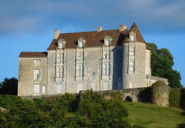
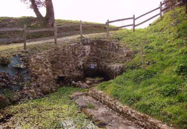
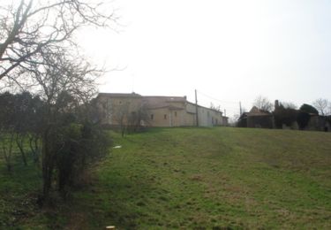
Belle randonnée, très vallonnée, paysages variés, très accessible.