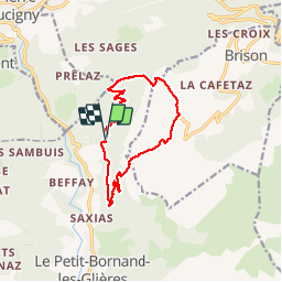
![](/images/other/stat-length.png)
![Tocht Stappen Glières-Val-de-Borne - Pointe d'Andey - Petit Bornand les Glières - Photo](https://media.geolcdn.com/t/1900/400/ext.pjpeg?maxdim=2&url=https%3A%2F%2Fstatic1.geolcdn.com%2Fsiteimages%2Fupload%2Ffiles%2F1553511878bg_sport_marche.png)
Pointe d'Andey - Petit Bornand les Glières
gebocarm
Gebruiker
![Lengte](/images/other/stat-length.png)
![Max. hoogte](https://static1.geolcdn.com/siteimages/upload/files/1508320355ic_sort_altitude_max_24dp.png)
![Positief hoogteverschil](https://static1.geolcdn.com/siteimages/upload/files/1508320355ic_sort_den_pos_24dp.png)
![Km-Effort](/images/other/stat-length.png)
![Min. hoogte](https://static1.geolcdn.com/siteimages/upload/files/1508320355ic_sort_altitude_min_24dp.png)
![Negatief hoogteverschil](https://static1.geolcdn.com/siteimages/upload/files/1508320355ic_sort_den_neg_24dp.png)
![Boucle](https://static1.geolcdn.com/siteimages/upload/files/16400158638029165_repeat_loop_refresh_sync_direction_icon.png)
![Stappen](https://static1.geolcdn.com/sitytour/trail-icons/101.png)
4h48
Moeilijkheid : Moeilijk
![Scan deze QR-code om de tocht te openen in de SityTrail-applicatie](https://capi.geolives.com/qq0zvz2zws4bq2lad0pu/sitytour/trails/307410/qr.png?size=200)
Gratisgps-wandelapplicatie
Over ons
Tocht Stappen van 11,6 km beschikbaar op Auvergne-Rhône-Alpes, Haute-Savoie, Glières-Val-de-Borne. Deze tocht wordt voorgesteld door gebocarm.
Beschrijving
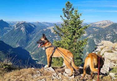
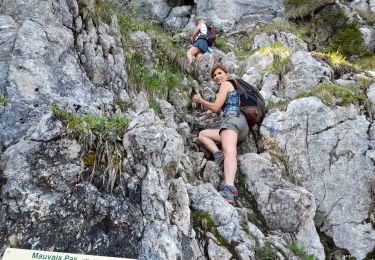
Du hameau de Termine (fin de la route goudronnée) à Petit-Bornand les Glières (854m), suivre le chemin en forêt assez large au début en direction du grand creux qui descend directement de la pointe d'Andey et qui passe par le "plan de la Torche" où vous rejoignez l'arrête séparant la vallée du Borne de la vallée de l'Arve, puis par "Dometta" en direction d'un petit col surplombant la falaise de Leschaux. A ce col, vous êtes à la limite des communes de Petit-Bornand et Brizon et vous apercevez devant vous le plateau de Solaison. Continuez environ 15 minutes sur le sentier rocheux qui s'incurve vers la gauche. Voilà, vous y êtes (1877m). Vous venez d'avaler 1023m de dénivellation et vous pouvez admirer toute la basse vallée de l'Arve dans un magnifique panorama sur 360°. Une variante du retour par le même itinéraire pourra être la descente par la brèche de Leschaux appelée communément 'R'venne' pour les autochtones 'Borniands'. Descendre face à la pente (sentier bien marqué) en direction du plateau de Solaison, puis arrivés aux premières habitations, suivre la route qui continue vers la droite et le fond du plateau. Poursuivre vers l'extrémité basse du plateau (ouest) puis arrivés aux premiers sapins qui barrent la vue vers la vallée du Borne, chercher le chemin qui s'incurve vers la gauche pour arriver à un goulet étroit et pentu qui marque véritablement une saignée dans la face de Leschaux. Descendre par ce couloir jusqu'à la forêt située sous la falaise de Leschaux puis chercher la piste forestière qui vous ramènera au point de départ.
Plaatsbepaling
Opmerkingen
Wandeltochten in de omgeving
![Tocht Stappen Glières-Val-de-Borne - BARGY: ROCHERS DE LESCHAUX AU DEPART DE CENISE - Photo](https://media.geolcdn.com/t/375/260/5ac05f8e-3735-47a8-a18c-c0c850908ba7.jpg&format=jpg&maxdim=2)
![Stappen Stappen](https://static1.geolcdn.com/sitytour/trail-icons/101.png)
Stappen
![](/images/other/stat-length.png)
![](https://static1.geolcdn.com/siteimages/upload/files/16400158638029165_repeat_loop_refresh_sync_direction_icon.png)
![Tocht Stappen Mont-Saxonnex - Les Rochers de Leschaux, 1936m - Mont Saxonex - Photo](https://media.geolcdn.com/t/375/260/ext.jpg?maxdim=2&url=https%3A%2F%2Fservices.sitytrail.com%2FGeolivesWS%2FDownloadMedia.ashx%3FTrailID%3D172447%26Media%3D13800_1.jpg)
![Stappen Stappen](https://static1.geolcdn.com/sitytour/trail-icons/101.png)
Stappen
![](/images/other/stat-length.png)
![](https://static1.geolcdn.com/siteimages/upload/files/16400158638029165_repeat_loop_refresh_sync_direction_icon.png)
![Tocht Ski randonnée Glières-Val-de-Borne - Tour du Jallouvre par le lac de Lessy - Photo](https://media.geolcdn.com/t/375/260/1d705345-d276-40a8-b673-92ff954efff5.jpg&format=jpg&maxdim=2)
![Ski randonnée Ski randonnée](https://static1.geolcdn.com/sitytour/trail-icons/503.png)
Ski randonnée
![](/images/other/stat-length.png)
![](https://static1.geolcdn.com/siteimages/upload/files/16400158638029165_repeat_loop_refresh_sync_direction_icon.png)
![Tocht Ski randonnée Glières-Val-de-Borne - col du rasoir combe NW ET Sud - Photo](https://media.geolcdn.com/t/375/260/c51ae7d8-65f2-4ba4-b4a6-8cbff7bf96a0.jpg&format=jpg&maxdim=2)
![Ski randonnée Ski randonnée](https://static1.geolcdn.com/sitytour/trail-icons/503.png)
Ski randonnée
![](/images/other/stat-length.png)
![](https://static1.geolcdn.com/siteimages/upload/files/16400158638029165_repeat_loop_refresh_sync_direction_icon.png)
![Tocht Stappen Glières-Val-de-Borne - Petit Bornand - Pointe d'Andey 29/07/2018 - Photo](https://media.geolcdn.com/t/375/260/d11e3746-7609-4ae6-897f-3a7f87c8818d.jpg&format=jpg&maxdim=2)
![Stappen Stappen](https://static1.geolcdn.com/sitytour/trail-icons/101.png)
Stappen
![](/images/other/stat-length.png)
![](https://static1.geolcdn.com/siteimages/upload/files/16400158638029165_repeat_loop_refresh_sync_direction_icon.png)
![Tocht Stappen Glières-Val-de-Borne - BARGY: LAC DE LESSY - Photo](https://media.geolcdn.com/t/375/260/06d01766-eea3-467c-b01f-e9f0d3a61660.jpg&format=jpg&maxdim=2)
![Stappen Stappen](https://static1.geolcdn.com/sitytour/trail-icons/101.png)
Stappen
![](/images/other/stat-length.png)
![](https://static1.geolcdn.com/siteimages/upload/files/16400158638029165_repeat_loop_refresh_sync_direction_icon.png)
![Tocht Stappen Brizon - BARGY: SOLAISON - CENISE par le](https://media.geolcdn.com/t/375/260/8d99e16f-5dc8-4624-b531-7bcb887f7aec.jpg&format=jpg&maxdim=2)
![Stappen Stappen](https://static1.geolcdn.com/sitytour/trail-icons/101.png)
Stappen
![](/images/other/stat-length.png)
![](https://static1.geolcdn.com/siteimages/upload/files/16400158638029165_repeat_loop_refresh_sync_direction_icon.png)
![Tocht Stappen Glières-Val-de-Borne - 2022- Rochers de Leschaux - AR - Photo](https://media.geolcdn.com/t/375/260/279a636c-2a60-4284-9cdd-e6183412d2d9.jpg&format=jpg&maxdim=2)
![Stappen Stappen](https://static1.geolcdn.com/sitytour/trail-icons/101.png)
Stappen
![](/images/other/stat-length.png)
![](https://static1.geolcdn.com/siteimages/upload/files/16400158638029165_repeat_loop_refresh_sync_direction_icon.png)
![Tocht Stappen Brizon - BARGY: SOLAISON - CENISE PAR LE MAUVAIS PAS - ROCHERS DE LESCHAUX - Photo](https://media.geolcdn.com/t/375/260/738c3540-bc10-4f9d-b031-b38d888f2feb.jpg&format=jpg&maxdim=2)
![Stappen Stappen](https://static1.geolcdn.com/sitytour/trail-icons/101.png)
Stappen
![](/images/other/stat-length.png)
![](https://static1.geolcdn.com/siteimages/upload/files/16400158638029165_repeat_loop_refresh_sync_direction_icon.png)